WSR 14-14-133
PROPOSED RULES
DEPARTMENT OF
FISH AND WILDLIFE
[Filed July 2, 2014, 11:04 a.m.]
Original Notice.
Preproposal statement of inquiry was filed as WSR 11-16-050 on July 28, 2011.
Title of Rule and Other Identifying Information: Repealing chapter 220-110 WAC, Hydraulic code rules and replace with chapter 220-660 WAC, Hydraulic code rules.
Hearing Location(s): Natural Resources Building, Room 172, 1111 Washington Street S.E., Olympia, WA 98504, on August 8-9, 2014, at 8:30 a.m.
Date of Intended Adoption: On or after September 26, 2014.
Submit Written Comments to: Randi Thurston, 600 Capitol Way North, Olympia, WA 98501-1091, e-mail Randi.Thurston@dfw.wa.gov, fax (360) 902-2602, by August 1, 2014.
Assistance for Persons with Disabilities: Contact Tami Lininger by August 7, 2014, (360) 902-2207 or TTY 1-800-833-6388.
Purpose of the Proposal and Its Anticipated Effects, Including Any Changes in Existing Rules: The hydraulic code rules detail how hydraulic projects must be conducted to protect fish life. Hydraulic code rules and related administrative procedures have not been significantly updated since 1994. The proposed rule changes update the rules and clarify the application and permit-processing procedures, enabling the department to prevent or mitigate the impacts to fish life and habitat posed by hydraulic projects through the best available science. To facilitate these rule changes and prepare for the upcoming recodification of department WACs, the department proposes repealing chapter 220-110 WAC and creating new rules in chapter 220-660 WAC.
The department prepared a supplemental draft programmatic environmental impact statement (PEIS) on the proposed changes to the hydraulic code rules. Comments on the draft EIS and proposed rules are being taken separately but concurrently. The PEIS will be available for a thirty day public review beginning July 16, 2014, and will be available online at http://wdfw.wa.gov/licensing/sepa/sepa_comment_docs.html. The document may be obtained in hard copy or CD by written request to the SEPA responsible official at SEPAdesk2@dfw.wa.gov, or by fax (360) 902-2946.
Reasons Supporting Proposal: Existing rules have not been updated to account for statutory changes to chapter 77.55 RCW or to changes in method to protect fish life from the impacts of a variety of hydraulic project types in waters of the state. In addition, methods for submitting and processing applications have changed and the rules need to be updated to account for modern practices for administering the processing of applications.
Statutory Authority for Adoption: RCW 77.04.012, 77.04.020, and 77.12.047.
Statute Being Implemented: RCW 77.04.012, 77.04.020, and 77.12.047.
Rule is not necessitated by federal law, federal or state court decision.
Name of Proponent: Washington department of fish and wildlife (WDFW), governmental.
Name of Agency Personnel Responsible for Drafting: Randi Thurston, 1111 Washington Street S.E., Olympia, WA 98504, (360) 902-2602; Implementation: Lisa Veneroso, 1111 Washington Street S.E., Olympia, WA 98504, (360) 902-2836; and Enforcement: Steve Crown, 1111 Washington Street S.E., Olympia, WA 98504, (360) 902-2373.
A small business economic impact statement has been prepared under chapter 19.85 RCW.
Small Business Economic Impact Statement
1 Background and Scope:
1.1 Small Business Economic Impact Statement (SBEIS): Prior to adopting a rule RCW 34.05.325 directs an agency to: Determine that the probable benefits of the rule are greater than its probable costs, taking into account both the qualitative and quantitative benefits and costs and the specific directives of the statute being implemented …
In addition the Regulatory Fairness Act, in RCW 19.85.040, directs that: To determine whether the proposed rule will have a disproportionate cost impact on small businesses, the impact statement must compare the cost of compliance for small business with the cost of compliance for the ten percent of businesses that are the largest businesses required to comply with the proposed rules …
In RCW 19.85.020(3) "Small business" is defined as: … any business entity, including a sole proprietorship, corporation, partnership, or other legal entity, that is owned and operated independently from all other businesses, and that has fifty or fewer employees.
This report presents the findings of both the cost-benefit analysis (CBA), as directed under RCW 34.05.325, and the SBEIS, as directed under RCW 19.85.040.
1.2 Public participation and review of proposed rules: WDFW has involved the public and stakeholders in developing the updated hydraulic code rules. WDFW formed a stakeholder advisory group to provide comments on an initial draft of the HPA rules. This group included eighteen representatives from the construction industry, nongovernmental organizations, state and federal agencies, and tribes. This group met eight times between October 31 and the end of December 2011, receiving presentations on and discussing issues relating to one or two specific aspects of the HPA rules at each meeting. The group engaged in policy discussions about the proposed changes and the impacts to their interests, and commented on revised rule proposals prepared by WDFW. Those rule documents were also posted on the WDFW web site for comment by any reader. Three separate drafts of the revised code rules have been posted on the WDFW web site along with forms to comment on the rules. The fourth draft accompanied the September 2013 PEIS. A final draft accompanies this supplemental draft PEIS. This draft was revised based on September 2013 PEIS comments and will be finalized concurrent with the final EIS. The fish and wildlife commission will consider the final draft rules and hear public testimony prior to adopting final rules in the summer of 2014.
2 Proposed Action and Baseline:
2.1 Changes under the proposed rules: The proposed rule changes will update the requirements and make them consistent with statutory, procedural, and administrative changes and current fish science and design technology. Specifically the rule changes will:
• | Incorporate up-to-date fish science and technology; |
• | Simplify the permitting of certain types of projects; |
• | Improve procedural and administrative requirements to better align with statutory changes made since the rules were last revised; and |
• | Establish a structure for adaptive management in response to changing science and technology and/or the results of effectiveness monitoring. |
2.2 Baseline: Defining the baseline, against which to measure potential impacts of the proposed changes to the hydraulic code rules, is not as simple as comparing the existing rules, last updated in 1994, to the proposed changes. Other federal and state regulatory authorities and judicial decisions dictate the design, construction and maintenance of projects located in waters of the state. If a permittee is required to follow other existing rule(s), regulation(s) and standard(s) that are the same or more stringent than those proposed by WDFW, then the economic impact attributable to WDFW's proposed rule change would be minimized, or even eliminated. For instance, comparing a road culvert designed according to the change proposed to WAC 220-660-190 Water crossing structures, to an existing culvert size might increase the cost of the design and/or construction of the culvert, but the existing culvert does not satisfy the fish passage required [by] National Marine Fisheries Service Anadromous Salmonid Passage Facility Design (see Section 2.2.1.1, below). Therefore to assign the costs of the proposed rule changes in WAC 220-660-190 would overstate the impact of the proposed rule change.
3 Data Profile, Methods and Results: WDFW maintains a database of hydraulic project approval (HPA) applications. The database contains information about individual applications including the year the application was submitted, the status of the application, the name of the company (or individual) submitting the application and categorizes the applicants into groups. The applicant groups are:
• | Agriculture, including farms, timber companies and local dike, drainage and irrigation districts; |
• | Single family residence; |
• | Multiple family use including homeowners' associations; |
• | Commercial/industrial, including energy companies, land development, private marinas, etc.; |
• | Government, including federal, tribal, state and regional; |
• | Nonprofit agency public; |
• | Nonprofit agency private. |
The method used to estimate the probable costs of the proposed rule changes answered the following questions:
• | How many HPAs will be submitted annually that have to meet the requirements of a proposed rule change for which there are no related regulations (see Table 1)? |
• | What is a reasonable range of estimated costs for those proposed rule changes? |
Estimates of both the range of costs and the annual volume of HPAs are used to estimate a range of implementation costs of the proposed rule changes. For example, if a proposed rule change is likely to increase project costs significantly but the likelihood that any project will be effected [affected] by the proposed change is low, then the expected cost of the proposed rule change could be low. Conversely, if the cost of implementing a proposed rule change on any one project is relatively low, but the proposed rule change would likely impact a relatively high percentage of projects seeking an HPA then the expected cost of the proposed rule change could be high.
In addition to understanding the potential costs and annual number of proposed rule change[s] this analysis also answered the following:
• | Who (which entities) might be impacted by the proposed rule changes, e.g. federal and state agencies, tribes, commercial and industrial users, residential, etc.? |
Understanding the type of entity (e.g. agriculture, government, etc.) impacted by the proposed rule changes contributes to the SBEIS, which estimates whether a small business is disproportionate[ly] affected by the proposed rule changes. Also, understanding which entity might be impacted helps estimate the number of HPAs that would be exempt from the 404 permitting requirement.
To answer two of the above three questions; (1) how many HPAs are submitted in one year and (2) which applicants might be impacted by the proposed rule change, the analysis assumed that the historical record of HPAs, that is - the types of projects that have needed permits and the types of entities that applied - represents the best estimate of future projects and applicants.
WDFW maintains a database of HPA applications (Chapman, 2014a). Table 2 shows the number of HPAs issued per year from 2008 through 2012. On average over 2,500 applications are issued per year.
Table 2. Number of HPAs issued per year, 2008-2012, all projects, all applicants, excluding forestry.
Year |
2008 |
2009 |
2010 |
2011 |
2012 |
Grand Total |
5-Year Average |
HPA Count |
2,657 |
2,666 |
2,177 |
2,456 |
2,782 |
12,738 |
2,548 |
Source: Barber, E. 2014.
What follows is a description of the historical record of HPAs issued over the five-year period from 2008 to 2012, including an estimate of how many applications would have been impacted by the proposed rules had the rules been in effect during that period of time. Also, a description of the estimated costs of each HPA is described.
3.1 Who Applies for HPAs? The WDFW HPA database contains information about individual applications including (but not limited to) the:
• | Year the application was submitted; |
• | Status of the application (pending, issued, hold, etc.); |
• | Type of application (e.g. forest practice, JARPA, public notice, etc.); |
• | Description of the project; |
• | Name of the company (or individual) submitting the application; |
• | Applicant groups (e.g. government, agriculture, commercial/industrial, residential, etc.). |
Table 3 lists the number of HPAs issued between 2008 and 2012 by applicant group. Single family residences and government are the top two applicant groups, each individually representing just over 35.0 percent of all the HPAs, for a combined total of seventy percent of the HPAs for the time period. Agricultural applicants are third in volume, with 14.0 percent of the HPAs from 2008-2012, followed by commercial/industrial applicants submitting 8.0 percent of all HPAs. The remainder of the applicant groups represent less than 6.0 percent of all HPAs for the study period.
Table 3. Total HPAs by Applicant Group, 2008 - 2012
Applicant Group |
Number of HPAs |
Percent of Total |
|
5-Year Total |
5-Year Average |
||
Agriculture |
1,737 |
249 |
14% |
Commercial/Industrial |
964 |
961 |
8% |
Government |
4,606 |
46 |
36% |
Multiple Family Use |
225 |
90 |
2% |
Nonprofit Agency Private |
419 |
21 |
3% |
Nonprofit Agency Public |
101 |
937 |
1% |
Single Family Residence |
4,686 |
243 |
37% |
Grand Total |
12,738 |
2,548 |
100% |
Source: Barber, E. 2014.
3.2 How Many HPAs Could Be Subject to the Proposed Rule Changes?
Table 4 presents an estimate of the average annual number of HPAs, issued between 2008 and 2013, that may have been subject to a proposed rule change, had the rules been in effect at the time. Note that any one HPA may be included in Table 4 in multiple columns, as one HPA could be subject to more than one rule.
The majority of all HPAs, approximately 32.0 percent, issued between 2008 and 2013 were subject to proposed WAC 220-660-190 Water crossing structure. Twenty percent of all applications issued between 2008 and 2013 would have been subject to proposed WAC 220-660-310 Tidal reference areas, and proposed WAC 220-660-330 Authorized work times in saltwater areas. Thirteen percent of the HPAs would have been subject to five proposed rules; freshwater habitats of special concern (WAC 220-660-100), residential and public recreational docks, piers, ramps, floats, watercraft lifts, and buoys in freshwater areas (WAC 220-660-140), saltwater habitats of special concern (WAC 220-660-320), intertidal forage fish spawning bed surveys (WAC 220-660-340) and seagrass and macroalgae habitat surveys (WAC 220-660-350). The remainder of the rules would have impacted ten percent or less of the HPAs.
Table 4. Estimate of the Average Annual Percent of Total HPAs by Proposed Rules, 2008-2013.
Proposed WAC Sections |
Percent of Total |
|
Number |
Title |
|
220-660-100 |
Freshwater habitats of special concern |
12.9% |
220-660-110 |
Authorized work times in freshwater areas |
0.0% |
220-660-120 |
Common freshwater construction provisions |
0.0% |
220-660-130 |
Streambank protection and lake shoreline stabilization |
0.0% |
220-660-140 |
Residential and public recreational docks, piers, ramps, floats, watercraft lifts, and buoys in freshwater areas |
12.9% |
220-660-150 |
Boat ramps and launches in freshwater areas |
0.9% |
220-660-160 |
Marinas and terminals in freshwater areas |
0.3% |
220-660-170 |
Dredging in freshwater areas |
7.8% |
220-660-180 |
Sand and gravel removal |
0.3% |
220-660-190 |
Water crossing structures |
31.8% |
220-660-200 |
Fish passage improvement structures |
9.4% |
220-660-210 |
Channel relocation and realignment |
0.1% |
220-660-220 |
Large woody material placement, repositioning, and removal in freshwater areas |
7.1% |
220-660-230 |
Beaver dam management |
1.1% |
220-660-240 |
Pond construction |
0.3% |
220-660-250 |
Water diversions and intakes |
4.2% |
220-660-260 |
Outfall structures in freshwater areas |
1.8% |
220-660-270 |
Utility crossings in freshwater areas |
2.6% |
220-660-280 |
Felling and yarding of timber |
0.1% |
220-660-290 |
Aquatic plant removal and control |
0.3% |
220-660-300 |
Mineral prospecting |
8.9% |
220-660-310 |
Tidal reference areas |
19.7% |
220-660-320 |
Saltwater habitats of special concern |
13.4% |
220-660-330 |
Authorized work times in saltwater areas |
19.7% |
220-660-340 |
Intertidal forage fish spawning bed surveys |
13.2% |
220-660-350 |
Seagrass and macroalgae habitat surveys |
13.4% |
220-660-370 |
Bank protection in saltwater areas |
5.9% |
220-660-380 |
Residential and public recreational docks, piers, ramps, floats, watercraft lifts and buoys in saltwater areas |
5.2% |
220-660-390 |
Boat ramps and launches in saltwater areas |
0.7% |
220-660-400 |
Marinas and terminals in saltwater areas |
0.6% |
220-660-410 |
Dredging in saltwater areas |
0.6% |
220-660-420 |
Artificial Aquatic Habitat Structures |
0.4% |
Source: Barber, E. WDFW 2014.
Table 5 shows the annual average number of HPAs assumed to be subject to the proposed rule changes by applicant group. Included in Table 5 are the proposed rules that could potentially impact greater than 5.0 percent of the annual average number of HPAs. As seen in Table 4, 32.0 percent of the average annual HPAs are subject to proposed WAC 220-660-190 Water crossing structures. Of those HPAs the majority, 49.0 percent, are issued to governments. Twenty percent of the HPAs subject to the water crossing structures proposed rule are issued to agricultural and forestry applicants. Sixteen percent of the HPAs subject to the water crossing structures rule are issued to commercial and industrial applicants.
The single family residence applicant group is issued the largest number of HPAs (64.0 percent) that are subject to the proposed Tidal reference area rule (WAC 220-660-310) and proposed Authorized work times in saltwater areas rule (WAC 220-660-330). Governments are issued 21.0 percent of HPAs subject to these two proposed rules.
Governments and single family residents continue to be the two applicant groups with the majority of the HPAs subject to the proposed rule for nearly all other proposed rules except fish passage improvement structures (WAC 220-660-200). With fish passage improvement structures, governments are still issued the most (37.0 percent) of all HPAs; however, the commercial/industrial and agriculture and forestry applicant group receive 30.0 percent and 25.0 percent of the HPAs, respectively.
Table 5. Estimated Five-Year Average Annual Number of HPAs by Rule and Applicant Group, Ordered by Volume, 2008-2012.
Proposed WAC Sections |
Agriculture and Forestry |
Commercial /Industrial |
Government |
Multiple Family Use |
Nonprofit Agency |
Single Family Residence |
Grand Total |
Percent of Total |
||
Number |
Title |
Private |
Public |
|||||||
220-660-190 |
Water crossing structures |
159 |
133 |
393 |
9 |
17 |
4 |
95 |
810 |
32% |
% by applicant |
20% |
16% |
49% |
1% |
2% |
0% |
12% |
100% |
||
220-660-310 |
Tidal reference areas |
7 |
36 |
104 |
13 |
19 |
3 |
319 |
501 |
20% |
% by applicant |
1% |
7% |
21% |
3% |
4% |
1% |
64% |
100% |
||
220-660-330 |
Authorized work times in saltwater areas |
7 |
36 |
104 |
13 |
19 |
3 |
319 |
501 |
20% |
% by applicant |
1% |
7% |
21% |
3% |
4% |
1% |
64% |
100% |
||
220-660-100 |
Freshwater habitats of special concern |
20 |
17 |
162 |
5 |
11 |
2 |
111 |
328 |
13% |
% by applicant |
6% |
5% |
49% |
2% |
3% |
1% |
34% |
100% |
||
220-660-140 |
Residential and public recreation docks, piers, ramps, floats, watercraft lifts, and buoys in freshwater areas |
12 |
23 |
33 |
14 |
16 |
1 |
228 |
327 |
13% |
% by applicant |
4% |
7% |
10% |
4% |
5% |
0% |
70% |
100% |
||
220-660-320 |
Saltwater habitats of special concern |
6 |
32 |
83 |
12 |
16 |
1 |
192 |
342 |
13% |
% by applicant |
2% |
9% |
24% |
4% |
5% |
0% |
56% |
100% |
||
220-660-340 |
Intertidal forage fish spawning bed surveys |
6 |
30 |
82 |
12 |
15 |
1 |
190 |
336 |
13% |
% by applicant |
2% |
9% |
24% |
4% |
4% |
0% |
57% |
100% |
||
220-660-350 |
Seagrass and macroalgae habitat surveys |
6 |
32 |
83 |
12 |
16 |
1 |
192 |
342 |
13% |
% by applicant |
2% |
9% |
24% |
4% |
5% |
0% |
56% |
100% |
||
220-660-200 |
Fish passage improvement structures |
294 |
361 |
445 |
1 |
31 |
6 |
57 |
1,195 |
9% |
% by applicant |
25% |
30% |
37% |
0% |
3% |
1% |
5% |
100% |
||
220-660-300 |
Mineral prospecting |
5 |
2 |
1,130 |
1,137 |
9% |
||||
% by applicant |
0% |
0% |
0% |
0% |
0% |
0% |
99% |
100% |
||
220-660-170 |
Dredging in freshwater areas |
78 |
46 |
619 |
6 |
47 |
17 |
181 |
994 |
8% |
% by applicant |
8% |
5% |
62% |
1% |
5% |
2% |
18% |
100% |
||
220-660-220 |
Large woody material placement, repositioning, and removal in freshwater areas |
63 |
51 |
479 |
15 |
92 |
13 |
191 |
904 |
7% |
% by applicant |
7% |
6% |
53% |
2% |
10% |
1% |
21% |
100% |
||
220-660-370 |
Bank protection in saltwater areas |
7 |
34 |
142 |
13 |
23 |
3 |
527 |
749 |
6% |
% by applicant |
1% |
5% |
19% |
2% |
3% |
0% |
70% |
100% |
||
Table 7. Quantified and Qualified Estimated Costs of Implementing Proposed Rule Changes
 |
N/A = | Not Applicable; N/E = Not Estimated |
(i) | Unable to estimate the number of HPAs, also costs savings relatively small. |
(ii) | Number of HPAs estimated as the difference between the GHPAs issued and the number of individual projects completed under the GHPA. Cost conservatively estimated as the cost of the permit, not including labor to prepare the permit application. |
(iii) | Mitigation of the HPA applicants exempt from 404 permits, the cost of mitigation is project specific. |
(iv) | Sources: (a) Guy, 2011; (b) Stroud, 2011; (c) Kaczmarek, 2011; (d) Fabricatros and Manufactures Association; (e) Keidle, 2011. The number of HPAs was estimated where the number of applications is only those where Project_Environ = Freshwater or Marine as appropriate and applicant group = Agric & forestry. Costs are the percent increase in construction costs for material that complies with the proposed rule. |
(v) | Unable to estimate the number of HPAs, also costs savings would range widely based on project specifics. |
(vi) | Potential impact for HPAs where applicant is exempt from a 404 permit, e.g. farming, ranching, silviculture and projects costs vary widely. |
(vii) | Swarts, 2014, Thurston, 2014. |
4 SBEIS:
The Regulatory Fairness Act, in RCW 19.85.040, directs that: To determine whether the proposed rule will have a disproportionate cost impact on small businesses, the impact statement must compare the cost of compliance for small business with the cost of compliance for the ten percent of businesses that are the largest businesses required to comply with the proposed rules …
In RCW 19.85.020(3) "Small business" is defined as: … any business entity, including a sole proprietorship, corporation, partnership, or other legal entity, that is owned and operated independently from all other businesses, and that has fifty or fewer employees.
None of the proposed rule changes would have a disproportionate cost impact on small businesses.
A copy of the statement may be obtained by contacting Randi Thurston, 600 Capitol Way North, Olympia, WA 98501-1091, phone (360) 902-2602, fax (360) 902-2155, e-mail Randi.Thurston@dfw.wa.gov. A more detailed SBEIS, which includes the CBA, is available by contacting Randi Thurston using the contact information provided above.
A cost-benefit analysis is required under RCW 34.05.328. A preliminary cost-benefit analysis may be obtained by contacting Randi Thurston, 600 Capitol Way North, Olympia, WA 98501-1091, phone (360) 902-2602, fax (360) 902-2155, e-mail Randi.Thurston@dfw.wa.gov.
July 2, 2014
Joanna M. Eide
Rules Coordinator
Chapter 220-660 WAC
HYDRAULIC CODE RULES
NEW SECTION
WAC 220-660-010 Purpose.
A hydraulic project is the construction or performance of work that uses, diverts, obstructs, or changes the natural flow or bed of any of the salt or fresh waters of the state. Unless otherwise provided, any person who wants to conduct a hydraulic project must get a construction permit called the hydraulic project approval (HPA) from the department. The purpose of the HPA is to ensure that construction or performance of other work is done in a manner that protects fish life. This chapter establishes the rules for the department's HPA authority (chapter 77.55 RCW).
NEW SECTION
WAC 220-660-020 Instructions for using chapter 220-660 WAC.
The technical provisions in WAC 220-660-090 through 220-660-460 represent common provisions for the protection of fish life for typical projects proposed to the department. Implementation of these provisions is necessary to minimize project-specific and cumulative impacts to fish life. These provisions reflect the current and best science, technology, and construction practices related to the protection of fish life. The department will incorporate new science and technology as it becomes available, and will allow alternative practices that provide equal or greater protection for fish life.
The technical provisions will apply to a hydraulic project when included as provisions on the HPA. Each application will be reviewed on an individual basis. Common technical provisions applicable to a specific project may be modified or deleted by the department pursuant to WAC 220-660-070. HPAs may also have special provisions to address project-specific or site-specific considerations not adequately addressed by the common technical provisions. In addition, all hydraulic projects must meet the applicable mitigation requirements in WAC 220-660-080.
In addition to the rules in this chapter, the department has developed guidance to help applicants. This guidance reflects the department's experience and expertise with various types of hydraulic projects. Following the guidance will help ensure that a hydraulic project adequately protects fish life and will speed the department's review and decision process. All guidance documents are available on the department's web site.
NEW SECTION
WAC 220-660-030 Definitions.
The following are definitions for terms used in this chapter. Common terms that are already defined in statute are noted as such.
(1) "Abandoning an excavation site" means not working an excavation site for forty-eight hours or longer.
(2) "Aggregate" means a mixture of minerals separable by mechanical or physical means.
(3) "Aquatic beneficial plant" means all native and nonnative aquatic plants except those on the state noxious weed lists in WAC 16-750-005, 16-750-011, and 16-750-015.
(4) "Aquatic invasive species" means an invasive species of the animal kingdom with a life cycle that is at least partly dependent upon fresh, brackish, or marine waters. Examples include nutria, waterfowl, amphibians, fish, and shellfish.
(5) "Aquatic noxious weed" means an aquatic plant on the state noxious weed lists in WAC 16-750-005, 16-750-011, and 16-750-015.
(6) "Aquatic plant" means a native or nonnative emergent, submersed, partially submersed, free-floating, or floating-leaved plant species that is dependent upon fresh, brackish, or marine water ecosystems and includes all stages of development and parts.
(7) "Aquatic Plants and Fish pamphlet" means a document that details the rules for aquatic noxious weed and aquatic beneficial plant removal and control activities and that serves as the hydraulic project approval for certain plant removal and control activities in Washington state.
(8) "Artificial materials" means clean, inert materials used to construct diversion structures for mineral prospecting.
(9) "Associated human-made agricultural drainage facilities" means dikes, drains, pumps, drainage tiles, and drainage pipe made by humans that protect agricultural land.
(10) "Authorized agent" means someone who is authorized by the applicant to act on behalf of the applicant.
(11) "Bank" means any land surface landward of the ordinary high water line next to a body of water and constrains the water except during floods. The term bank also includes all land surfaces of islands within a body of water that are below the flood elevation of the surrounding body of water.
(12) "Bankfull width" means the width of the surface of the water at the point where water just begins to overflow into the active floodplain. In streams where there is no floodplain it is the width of a stream or river at the dominant channel forming flow with a recurrence interval in the one- to two-year range.
(13) "Beach area" means the beds between the ordinary high water line and extreme low water.
(14) "Bed" means the land below the ordinary high water lines of state waters. This definition does not include irrigation ditches, canals, storm water runoff devices, or other artificial watercourses except where they exist in a natural watercourse that has been altered artificially.
(15) "Bed materials" means naturally occurring materials such as gravel, cobble, rock, rubble, sand, mud, and aquatic plants that form the beds of state waters. Bed materials are also found in deposits or bars above the wetted perimeter of water bodies.
(16) "Board" means the pollution control hearings board created in chapter 43.21B RCW.
(17) "Bottom barrier or screen" means sheets of synthetic or natural fiber material used to cover and kill plants growing on the bottom of a watercourse.
(18) "Boulder" means a stream substrate particle larger than ten inches in diameter.
(19) "Bridge shadow" means the area under a bridge defined by the shadow cast by the sun. This area may not receive enough light and rain to support the plant growth needed for biotechnical bank stabilization.
(20) "Chronic danger" means a condition declared by the county legislative authority in which any property, except for property located on a marine shoreline, has experienced at least two consecutive years of flooding or erosion that has damaged or has threatened to damage a major structure, water supply system, septic system, or access to any road or highway.
(21) "Chronic danger HPA" means a written hydraulic project approval issued in response to a chronic danger declaration made by a county legislative authority.
(22) "Classify" means to sort aggregate by hand or through a screen, grizzly, or similar device to remove the larger material and concentrate the remaining aggregate.
(23) "Commission" means the Washington state fish and wildlife commission.
(24) "Compensatory mitigation" means the restoration, creation, enhancement, or preservation of aquatic resources for the purposes of compensating for unavoidable adverse impacts that remain after all appropriate and practicable avoidance and minimization has been achieved.
(25) "Concentrator" means a device used to physically or mechanically separate the valuable mineral content from aggregate.
(26) "Control" of an aquatic noxious weed means to prevent all seed production and to prevent the dispersal of all propagative parts capable of forming new plants.
(27) "County legislative authority" means a county commission, council, or other legislative body.
(28) "Crevicing" means removing aggregate from cracks and crevices using hand-held mineral prospecting tools or water pressure.
(29) "Critical food fish or shellfish habitats" means those habitats that are essential to fish life. These habitats include habitats of special concern listed in WAC 220-660-120 and 220-660-330 and habitats for priority fish and shellfish.
(30) "Department" means the department of fish and wildlife.
(31) "Design flood" means a stream discharge of a specific rate and probability that is best suited for the design of a project to create and shape habitat or to protect property and structures to a given level of risk (e.g., the 100-year design flood).
(32) "Director" means the director of the department of fish and wildlife.
(33) "Ditch" means a wholly artificial watercourse or a natural watercourse (waters of the state) altered by humans.
(34) "Diver-operated dredging" means the use of portable suction or hydraulic dredges held by SCUBA divers to remove aquatic plants.
(35) "Dredging" means removal of bed material using other than hand-held tools.
(36) "Early infestation" of an aquatic noxious weed means a stage of development, life history, or area of coverage that makes one hundred percent control and eradication likely to occur.
(37) "Emergency" means an immediate threat to life, the public, property, or of environmental degradation.
(38) "Emergency HPA" means a verbal or written hydraulic project approval issued in response to a declaration of emergency.
(39) "Entrained" means the entrapment of fish into a watercourse diversion that has no screen, into high velocity water along the face of an improperly designed screen, or into the vegetation cut by a mechanical harvester.
(40) "Equipment" means any device powered by internal combustion; hydraulics; electricity, except less than one horsepower; or livestock used as draft animals, except saddle horses; and the lines, cables, arms, or extensions associated with the device.
(41) "Eradication" of an aquatic noxious weed means to eliminate a noxious weed within an area of infestation.
(42) "Established ford" means a crossing place in a watercourse that was in existence and used annually before 1986 or permitted by the department in or after 1986, and has identifiable approaches on the banks.
(43) "Excavation line" means a line on the dry bed at or parallel to the water's edge. The department determines the distance from the water's edge for each project site. The excavation line may change with water level fluctuations.
(44) "Excavation site" means the pit, furrow, or hole from which aggregate is removed to process and recover minerals, or into which wastewater is discharged to settle out sediments.
(45) "Excavation zone" means the area between the excavation line and the bank or the center of the gravel bar.
(46) "Expedited HPA" means a written hydraulic project approval issued in those instances where when normal permit processing would result in a significant hardship for the applicant or unacceptable damage to the environment.
(47) "Farm and agricultural land" means those lands identified in RCW 84.34.020.
(48) "Filter blanket" means one or more layers of pervious materials (organic, mineral, or synthetic) designed and installed to provide drainage, yet prevent the movement of soil particles by flowing water.
(49) "Fish conservation bank" means a fish habitat creation, restoration, or enhancement project intended to provide a bank of credits to compensate for impacts to fish habitat from future development projects. Fish conservation banks are managed to optimize desired habitat for listed and at-risk fish species.
(50) "Fish habitat" means habitat, which is used by fish life at any life stage at any time of the year including potential habitat likely to be used by fish life, which could reasonably be recovered by restoration or management and includes off-channel habitat.
(51) "Fish habitat enhancement project" means a hydraulic project that meets criteria in RCW 77.55.181 (1)(a).
(52) "Fish habitat improvement structures or stream channel improvements" means natural materials such as large wood, rock, or synthetic materials such as chain or rope placed in or next to bodies of water to make existing conditions better for fish life. Examples are engineered logjams, large woody material, and boulders.
(53) "Fish guard" means a device installed at or near a surface water diversion head gate, or on the intake of any device used for pumping water from fish-bearing waters, to prevent entrainment, injury, or death of fish life. Fish guards physically keep fish from entering the diversion or pump intake and do not rely on avoidance behavior.
(54) "Fish life" means all fish species, including food fish, shellfish, game fish, nonclassified fish and shellfish species, and all stages of development of those species.
(55) "Fish passage improvement structure" means artificial structures that are used to provide passage through, over, and/or around artificial barriers. They provide a graduated change in gradient with refuge areas allowing fish to pass barriers.
(56) "Fish screen" means "fish guard."
(57) "Flood gate" means a structure to control flooding through which water flows freely in one direction but is prevented from flowing in the other direction.
(58) "Food fish" means those species of the classes Osteichthyes, Agnatha, and Chondrichthyes that must not be fished for except as authorized by rule of the commission.
(59) "Forest practices hydraulic project" means a hydraulic project that requires a forest practices application or notification under chapter 76.09 RCW.
(60) "Frequent scour zone" means the area between the wetted perimeter and the toe of the slope. The frequent scour zone is comprised of aggregate, boulders, or bedrock. Organic soils are not present in the frequent scour zone.
(61) "Freshwater area" means those state waters and associated beds below (waterward of) the ordinary high water line that are upstream of stream and river mouths. Freshwater areas also include all lakes, ponds, and tributary streams and surface-water-connected wetlands that provide or maintain fish habitat.
(62) "Functional grating" means the percent open area of the grating that is not covered or blocked by any objects such as structural components, framing wood, flotation tubs, or objects placed on the surface of the grating.
(63) "Ganged equipment" means two or more pieces of mineral prospecting equipment coupled together to increase efficiency. An example is adding a second sluice to a high-banker.
(64) "General provisions" means those provisions that are in every HPA.
(65) "Gold and Fish pamphlet" means a document that details the rules for conducting small-scale and other prospecting and mining activities and that serves as the hydraulic project approval for certain mineral prospecting and mining activities in Washington state.
(66) "Habitat function" means the natural attributes of a given habitat that support the fish and shellfish species that rely upon that habitat.
(67) "Habitat value" means an estimate of habitat quality, ecologically important functions and the relative value of the hydraulic project site within the watershed.
(68) "Hand-held equipment" means equipment held by hand and powered by internal combustion, hydraulics, pneumatics, or electricity. Examples are chainsaws, drills, and grinders.
(69) "Hand-held mineral prospecting tools" means:
(a) Tools used for mineral prospecting that are held by hand and are not powered by internal combustion, hydraulics, or pneumatics. Examples are metal detectors, shovels, picks, trowels, hammers, pry bars, hand-operated winches, and battery-operated pumps specific to prospecting; and
(b) Vac-pacs.
(70) "Hand-held tools" means tools held by hand and are not powered by internal combustion, hydraulics, pneumatics, or electricity. Examples are shovels, rakes, hammers, pry bars, and cable winches. This definition does not apply to hand-held tools used for mineral prospecting. See "hand-held mineral prospecting tools."
(71) "Hatchery" means any water impoundment or facility used for the captive spawning, hatching, or rearing of fish life.
(72) "High-banker" means a stationary concentrator operated outside the wetted perimeter of the body of water from which the water is removed and that uses water supplied by hand or by pumping. A high-banker consists of a sluice box, hopper, and water supply. Aggregate is supplied to the high-banker by means other than suction dredging. This definition excludes rocker boxes. See Figure 1.
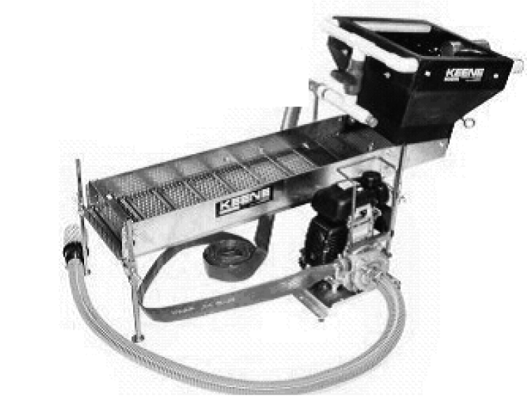 |
Figure 1: High-banker
(73) "High-banking" means using a high-banker to recover minerals.
(74) "Hydraulic drop" means an abrupt drop in water surface elevation.
(75) "Hydraulic project" means the construction or performance of work that will use, divert, obstruct, or change the natural flow or bed of any of the salt or freshwaters of the state.
(76) "Hydraulic project approval" or "HPA" means:
(a) A written approval for a hydraulic project issued under this chapter and signed by the director of the department or the director's designee; or
(b) A verbal approval for an emergency hydraulic project issued under this chapter by the director of the department or the director's designee; or
(c) The following printed pamphlet approvals:
(i) A "Gold and Fish" pamphlet issued under this chapter by the department, which identifies and authorizes specific minor hydraulic project activities for mineral prospecting and placer mining; or
(ii) An "Aquatic Plants and Fish" pamphlet issued under this chapter by the department, which identifies and authorizes specific aquatic noxious weed and aquatic beneficial plant removal and control activities.
(77) "Imminent danger" means a threat by weather, water flow, or other natural conditions that is likely to occur within sixty days of a request for a permit application.
(78) "In-lieu fee (ILF) program" means a state or federal certified program authorizing a person pay a fee to a third party in lieu of conducting project-specific mitigation or buying credits from a mitigation or fish conservation bank.
(79) "In-water blasting" means the use of explosives on, under, or in waters of the state, or in any location adjacent to the waters of the state, where blasting could impact fish life or fish habitat.
(80) "Job site" means the area of ground including and immediately adjacent to the area where work is conducted under an HPA. For mineral prospecting and placer mining projects, the job site includes the excavation site.
(81) "Joint aquatic resources permit application" or "JARPA" means a form provided by the department and other agencies that a person submits to request a written HPA for a hydraulic project.
(82) "Lake" means any natural standing fresh waters or artificially impounded fresh waters of the state, except impoundments of the Columbia and Snake rivers.
(83) "Large woody material" means trees or tree parts larger than four inches in diameter and longer than six feet, or rootwads, wholly or partially waterward of the ordinary high water line.
(84) "Macroalgae" means any of the nonvascular aquatic plant species (the red, green, or brown seaweeds) that can be seen without using a microscope. They may be attached to the substrate or other macroalgae by a holdfast, or found drifting individually or in mats.
(85) "Maintenance" means repairing, remodeling, or making minor alterations to a facility or project to keep the facility or project in properly functioning and safe condition.
(86) "Major modification" means any change to a hydraulic project that is not a minor modification.
(87) "Marina" means a public or private facility providing boat moorage space, fuel, or commercial services. Commercial services include, but are not limited to, overnight or live-aboard boating accommodations.
(88) "Marine terminal" means a public or private commercial wharf located in the navigable water of the state and used, or intended to be used, as a port or facility for the storing, handling, transferring, or transporting of goods to and from vessels.
(89) "Mean annual flood" means the average of all the annual peak floods of record.
(90) "Mean higher high water" or "MHHW" means the tidal elevation obtained by averaging each day's highest tide at a particular location over a period of nineteen years, as determined by National Oceanic and Atmospheric Administration (NOAA). It is measured from mean lower low water, which is a reference datum used to delineate waters of the state in saltwater areas.
(91) "Mean lower low water" or "MLLW" means the 0.0 feet tidal elevation, as determined by NOAA. It is determined by averaging each day's lowest tide at a particular location over a period of nineteen years. MLLW is a reference datum used to delineate waters of the state in saltwater areas. NOAA provides detailed information on their "Tides, Currents, and Predictions" web site.
(92) "Mechanical harvesting and cutting" means partially removing or controlling aquatic plants by using aquatic mechanical harvesters, which cut and collect aquatic plants, and mechanical cutters, which only cut aquatic plants.
(93) "Mineral prospect" or "mineral prospecting" means to excavate, process, or classify aggregate using hand-held mineral prospecting tools and mineral prospecting equipment.
(94) "Mineral prospecting equipment" means any natural or manufactured device, implement, or animal (other than the human body) used in any aspect of prospecting for or recovering minerals.
(95) "Mini high-banker" means a high-banker with a riffle area of three square feet or less. See Figure 2.
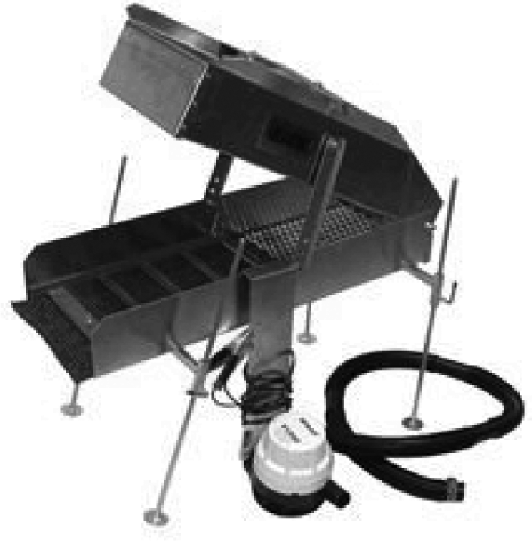 |
Figure 2: Mini high-banker
(96) "Mini rocker box" means a rocker box with a riffle area of three square feet or less. See Figure 3.
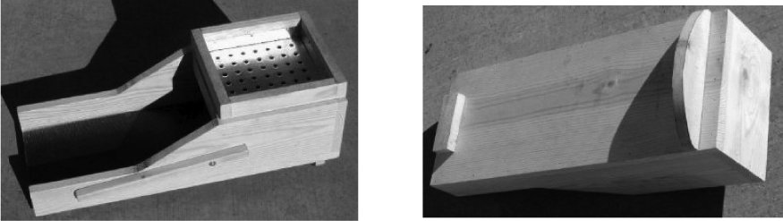 |
Figure 3: Mini rocker box (top view and bottom view)
(97) "Mining" means the production activity that follows mineral prospecting.
(98) "Minor modification" means a small change in work timing or plans and specifications of a hydraulic project.
(99) "Mitigation" means sequentially avoiding impacts, minimizing impacts, and compensating for remaining unavoidable impacts to fish life or habitat.
(100) "Mitigation bank" means a site where wetlands or other aquatic resources are restored, created, enhanced, or preserved. The bank exists expressly to provide compensatory mitigation before unavoidable impacts to wetlands or other aquatic resources occur.
(101) "Mitigation sequencing" means taking the steps in the mitigation sequence. The department and the applicant must consider and implement mitigation actions in the following sequential order:
(a) Avoid the impact altogether by not taking a certain action or parts of an action.
(b) Minimize impacts by limiting the degree or magnitude of the action and its implementation by using appropriate technology or by taking steps to avoid or reduce impacts.
(c) Rectify the impact by repairing, rehabilitating, or restoring the affected environment.
(d) Reduce or eliminate the impact over time by preservation or maintenance.
(e) Compensate for remaining unmitigated impacts by replacing, enhancing, or providing substitute resources or environments.
(f) Monitor the impact and take appropriate corrective measures to reach the identified goal.
(102) "Multiple site permit" means a hydraulic project approval issued to a person under RCW 77.55.021 for hydraulic projects occurring at more than one specific location and which includes site-specific requirements.
(103) "Natural conditions" means environmental situations that occur or are found in nature. This does not include artificial or manufactured conditions.
(104) "Nearshore zone" means the three critical "edge" habitats as follows: The edge between upland and aquatic environments, the edge between the shallow productive zone and deep water, and the edge between fresh and marine waters.
(105) "Ordinary high water line" or "OHWL" means the mark on the shores of all water that will be found by examining the bed and banks and ascertaining where the presence and action of waters are so common and usual, and so long continued in ordinary years as to mark upon the soil or vegetation a character distinct from the abutting upland. Provided, that in any area where the ordinary high water line cannot be found, the ordinary high water line adjoining saltwater is the line of mean higher high water and the ordinary high water line adjoining freshwater is the elevation of the mean annual flood.
(106) "Pan" means an open metal or plastic dish operated by hand to separate gold or other minerals from aggregate by washing the aggregate. See Figure 4.
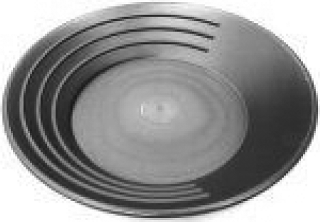 |
Figure 4: Pan
(107) "Panning" means the use of a pan to wash aggregate.
(108) "Permanent ford" means a ford approved by the department that is in place for more than one operating season.
(109) "Person" means an applicant, authorized agent, permittee, or contractor. The term person includes an individual, or a public or private entity, or organization.
(110) "Placer" means a glacial or alluvial deposit of gravel or sand containing eroded particles of minerals.
(111) "Pool" means a portion of the stream with reduced current velocity, often with water deeper than the surrounding areas.
(112) "Power sluice" means "high-banker."
(113) "Power sluice/suction dredge combination" means a machine that can be used as a power sluice, or with minor modifications, as a suction dredge. See Figure 5.
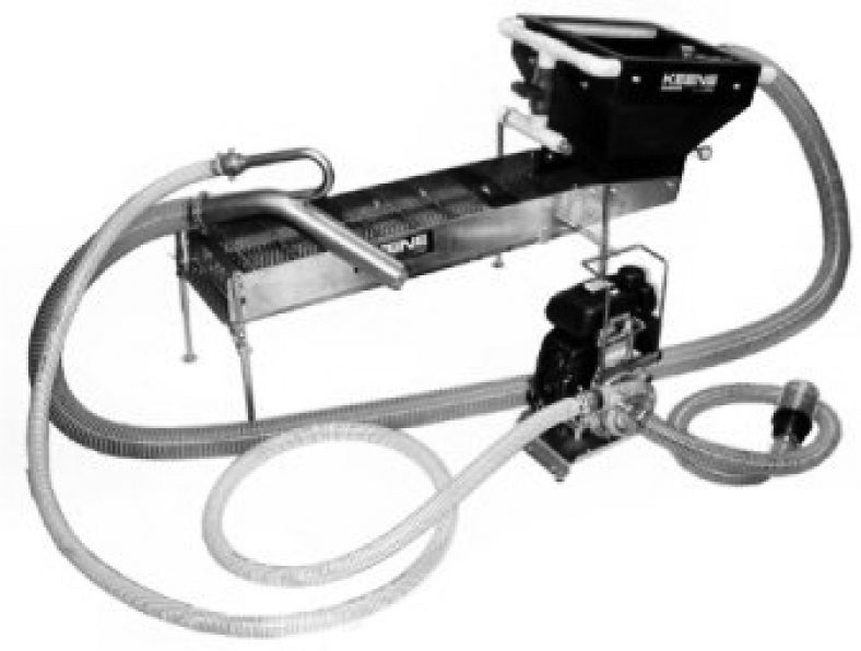 |
Figure 5: Power sluices/suction dredge combination
(114) "Process aggregate" or "processing aggregate" means the physical or mechanical separation of the valuable mineral content within aggregate.
(115) "Prospecting" means the exploration for minerals and mineral deposits.
(116) "Protection of fish life" means avoiding and minimizing impacts to fish life and fish habitat through mitigation sequencing.
(117) "Purple loosestrife" means Lythrum salicaria and Lythrum virgatum as classified in RCW 17.10.010(10) and defined in RCW 17.26.020 (5)(b).
(118) "Qualified professional" means a scientist, engineer, or technologist specializing in a relevant applied science or technology including fisheries or wildlife biology, engineering, geomorphology, geology, hydrology, or hydrogeology. This person may be certified with an appropriate professional organization, and acting under that association's code of ethics and subject to disciplinary action by that association. A qualified professional can also be someone who, through demonstrated education, experience, accreditation, and knowledge relevant to the particular matter, may be reasonably relied on to provide advice within that person's area of expertise.
(119) "Redd" means a nest made in gravel, consisting of a depression dug by a fish for egg deposition, and associated gravel mounds. See Figure 6.
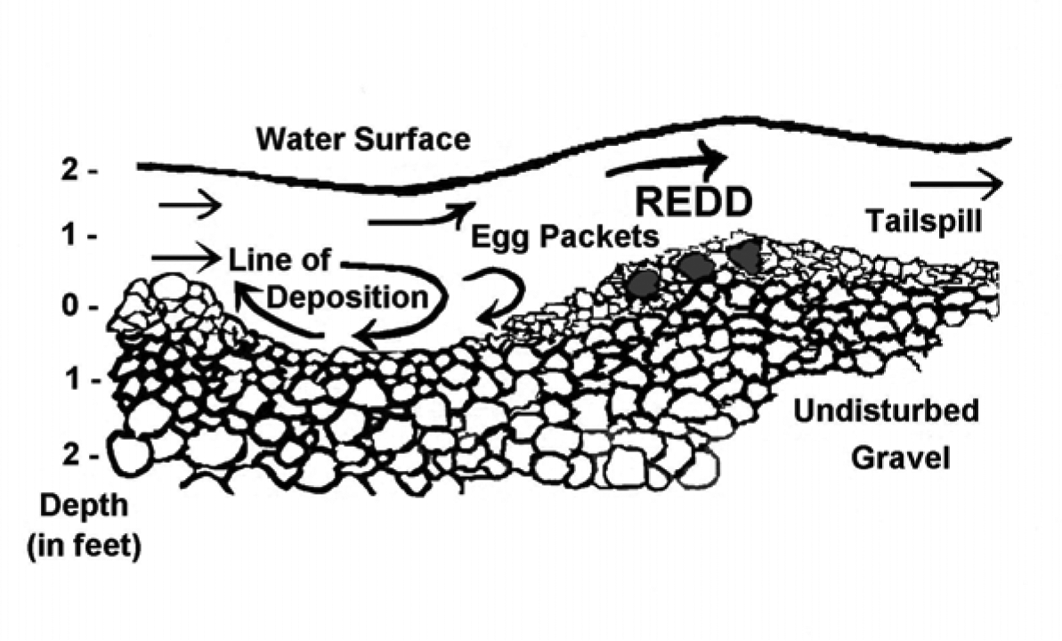 |
Figure 6: Cross-section of a typical redd
(120) "Rehabilitation" means major work required to restore the integrity of a structurally deficient or functionally obsolete structure. This can include partial replacement of a structure.
(121) "Replacement" means the complete removal of an existing structure and construction of a substitute structure in the same general location.
(122)(a) "Riffle" means the bottom of a concentrator containing a series of interstices or grooves to catch and retain a mineral such as gold; or
(b) "Riffle" means a short, relatively shallow and coarse-bedded length of stream over which the stream flows at higher velocity and higher turbulence than it normally does in comparison to a pool.
(123) "River" means "watercourse."
(124) "Riparian zones" means the land adjacent to streams, rivers, ponds, lakes, and those wetlands whose soils and vegetation are influenced by ponded or channelized water. They are the transition areas between aquatic and upland habitats with elements of both ecosystems.
(125) "Rocker box" means a nonmotorized concentrator consisting of a hopper attached to a cradle and a sluice box operated with a rocking motion. See Figure 7.
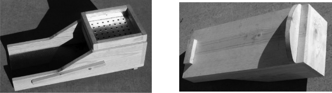 |
Figure 7: Rocker box
(126) "Rotovation" means the use of aquatic rotovators, machines that have underwater rototiller-like blades, to uproot aquatic plants as a means of control.
(127) "Roughened channel" means to construct a channel of a graded mix of sediment with enough roughness and hydraulic diversity to achieve fish passage. Roughened channels are designed to resist erosion and are often built at a steeper gradient than the prevailing channel.
(128) "Saltwater area" means those state waters with salinity as high as 35 parts per thousand of dissolved salts. It includes the associated beds below (waterward of) the ordinary high water line. Saltwater areas include estuaries and other surface water connected wetlands that provide or maintain fish habitat. Salinity in estuaries may range from 0.5 to 30 parts per thousand of dissolved salts.
(129) "Scientific measurement devices" means devices that measure and/or record environmental data, such as staff gauges, tide gauges, water recording devices, water quality testing and improvement devices, and similar instruments.
(130) "Seagrass" means native Zostera species, Ruppia maritima, and Phyllospadix species.
(131) "Shellfish" means those species of marine and freshwater invertebrates that have been classified and that must not be taken except as authorized by rule of the commission. The term shellfish includes all stages of development and the bodily parts of shellfish species.
(132) "Sluice" means a trough equipped with riffles across its bottom used to recover gold and other minerals with the use of flowing water. See Figure 8.
 |
Figure 8: Sluice
(133) "Spartina" means Spartina alterniflora, Spartina anglica, Spartina x townsendii, and Spartina patens as classified in RCW 17.10.010(10) and defined in RCW 17.26.020 (5)(a).
(134) "Special provisions" means those requirements that are part of a HPA, are site- or project-specific, and supplement or amend the technical provisions.
(135) "Spiral wheel" means a hand-operated or battery-powered rotating pan used to recover gold and minerals with the use of water. See Figure 9.
 |
Figure 9: Spiral wheel
(136) "Stable slope" means a slope without measurable evidence of slumping, sloughing, or other movement. Stable slopes will not show evidence of landslides, uprooted or tilted trees, exposed soils, water-saturated soils, and mud, or the recent erosion of soils and sediment. Woody vegetation is typically present on stable slopes.
(137) "Suction dredge" means a machine used to move submerged aggregate by hydraulic suction. The aggregate is processed through an attached sluice box to recover gold and other minerals. See Figure 10.
 |
Figure 10: Suction dredge
(138) "Suction dredging" means using a suction dredge to recover gold and other minerals.
(139) "Tailings" means the waste material that remains after processing aggregate to remove valuable mineral content.
(140) "Temporary ford" means a ford that is in place for no more than one operating season or less.
(141) "Tide gate" means a one-way check valve that prevents the backflow of tidal water.
(142) "Toe of the bank" means the distinct break in slope between the stream bank or shoreline and the stream bottom or marine beach or bed, excluding areas of sloughing. For steep banks that extend into the water, the toe may be submerged below (waterward of) the ordinary high water line. For artificial structures, such as jetties or bulkheads, the toe refers to the base of the structure where it meets the stream bed or marine beach or bed.
(143) "Toe of the slope" means the base or bottom of a slope at the point where the ground surface abruptly changes to a significantly flatter grade.
(144) "Unimpeded fish passage" means the free movement of all fish species at any mobile life stage around or through a human-made or natural structure.
(145) "Unstable slope" means a slope with visible or measurable evidence of slumping, sloughing, or other movement. Evidence of unstable slopes includes landslides, uprooted or tilted trees, exposed soils, water-saturated soils, and mud, or the recent erosion of soils and sediment. Woody vegetation is typically not present on unstable slopes.
(146) "Vac-pac" means a motorized, portable vacuum that you use for prospecting. See Figure 11.
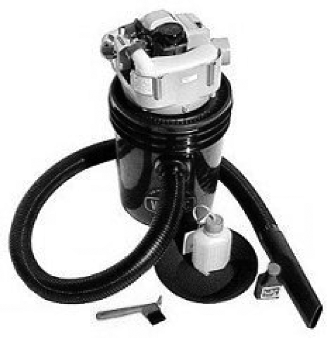 |
Figure 11: Vac-pac
(147) "Water crossing structures" means structures that span over, through, or under a watercourse. Examples are bridges, culverts, conduits, and fords.
(148) "Water right" means a certificate of water right, a vested water right or a claim to a valid vested water right, or a water permit, under Title 90 RCW.
(149) "Watercourse" or "stream" means any portion of a stream or river channel, bed, bank, or bottom waterward of the ordinary high water line of waters of the state. Watercourse also means areas in which fish may spawn, reside, or pass, and tributary waters with defined bed or banks that influence the quality of fish habitat downstream. Watercourse also means waters that flow intermittently or that fluctuate in level during the year, and the term applies to the entire bed of such waters whether or not the water is at peak level. A watercourse includes all surface-water-connected wetlands that provide or maintain fish habitat. This definition does not include irrigation ditches, canals, storm water treatment and conveyance systems, or other entirely artificial watercourses, except where they exist in a natural watercourse that has been altered by humans.
(150) "Waters of the state" or "state waters" means all salt and freshwaters waterward of the ordinary high water line and within the territorial boundary of the state. RCW 77.55.011(25).
(151) "Weed rolling" means the use of a mechanical roller designed to control aquatic plant growth.
(152) "Wetland(s)" is as defined in RCW 90.58.030.
(153) "Wetted perimeter" means the areas of a watercourse covered with water. The wetted perimeter varies with flow, discharge, and tides.
(154) "Woody vegetation" means perennial trees and shrubs having stiff stems and bark. Woody vegetation does not include grasses, forbs, or annual plants.
(155) "Written notice" or "written notification" means a communication via U.S. mail or via e-mail.
NEW SECTION
WAC 220-660-040 Applicability of hydraulic project approval authority.
(1) When an HPA is required: A person must obtain an HPA from the department before conducting a hydraulic project, unless the activity is exempt from this requirement as provided in subsection (2) of this section.
(2) No HPA is required for the following hydraulic projects:
(a) Installing oyster stakes, boundary markers, or property line markers by hand or with hand-held tools;
(b) Driving across an established ford (RCW 77.55.031);
(c) Remedial actions by the department of ecology or a person under a consent decree, order, or agreed order under RCW 70.105D.090 (RCW 77.55.061). Although no HPA is required, the department of ecology must ensure compliance with the substantive requirements of this chapter;
(d) Landscape management plans approved by the department and the department of natural resources under RCW 76.09.350(2) serve as an HPA for the life of the plan if fish are selected as one of the public resources covered under the plan (RCW 77.55.201);
(e) Removing derelict fishing gear according to the guidelines described in RCW 77.12.865 (RCW 77.55.041);
(f) Removing crab pots and other shellfish gear under a permit issued under RCW 77.70.500;
(g) An activity conducted solely to remove or control spartina (RCW 77.55.051);
(h) An activity conducted solely to remove or control purple loosestrife performed with hand-held tools, hand-held equipment, or equipment carried by a person (RCW 77.55.051);
(i) Installing or removing a portable boat hoist in a lake if the hoist:
(i) Is not permanently installed;
(ii) Does not have armoring or other structures installed for a foundation or protection;
(iii) Is not installed or removed using equipment operated below the OHWL;
(iv) Is not installed at the inlet or outlet of any stream;
(v) Does not require any dredging, filling, pile driving, or any other bed modifications during installation or removal;
(vi) Is not modified during or after installation by adding docks, ramps, floats, or other structures that add surface area to the hoist or allow for moorage of additional watercraft; and
(vii) Is not installed in any of the following sockeye salmon-bearing lakes:
(A) Baker;
(B) Cle Elum;
(C) Osoyoos;
(D) Ozette;
(E) Pleasant;
(F) Quinault;
(G) Sammamish;
(H) Washington; and
(I) Wenatchee.
(j) Installing, maintaining, or removing scientific measurement devices if:
(i) All work is conducted waterward of the OHWL by hand or with hand-held tools;
(ii) The project does not create a blockage to fish passage, even temporarily; and
(iii) The project does not include dewatering the worksite, placing fill or concrete, or excavating or grading the streambed or bank.
(k) Forest practices hydraulic projects, as defined in chapter 76.09 RCW; and
(l) Installation or maintenance of tideland and floating private sector commercial fish and shellfish culture facilities (RCW 77.12.047). However, an HPA is required for the construction of appurtenance structures, such as bulkheads or boat ramps, that use, divert, obstruct, or change the bed or flow of any of the salt or fresh waters of the state.
NEW SECTION
WAC 220-660-050 Procedures—Hydraulic project approvals.
(1) Description:
(a) There are six categories of HPAs: Standard, emergency, imminent danger, chronic danger, expedited, and pamphlet. These categories are discussed in more detail throughout this section. Most HPAs issued by the department are standard HPAs. Guidance for applying for an HPA is provided on the department's web site (wdfw.wa.gov).
(b) HPAs do not exempt a person from obtaining other necessary permits and following the rules and regulations of local, federal, and other Washington state agencies.
(2) Fish life concerns: Construction and other work activities in or near waterbodies can kill or injure fish or shellfish directly and can damage or destroy their habitat. Damaged or destroyed habitat can continue to cause lost production of fish and shellfish for as long as the habitat remains altered. HPAs help reduce the impacts of construction and other work to fish, shellfish, and their habitat.
(3) Standard HPA:
(a) The department issues a standard HPA when a hydraulic project does not qualify for an emergency, imminent danger, chronic danger, expedited or pamphlet HPA. A regular standard HPA is limited to a single project site.
(b) Special types of standard HPAs:
(i) Fish habitat enhancement project (FHEP) HPA.
(A) Projects must satisfy the requirements in RCW 77.55.181(1) to be processed as a fish habitat enhancement project.
(B) Projects that are compensatory mitigation for a development or other impacting project are not eligible. This includes proposals for mitigation banks or in-lieu fee mitigation proposals. The sole purpose of the project must be for fish habitat enhancement.
(C) The department may reject an FHEP proposed under RCW 77.55.181 if the local government raises concerns during the comment period that impacts from the project cannot be mitigated by conditioning the HPA. The department will reject an FHEP if the department determines that the size and the scale of the project raises public health or safety concerns. If the department rejects a project for streamlined processing, the department must provide written notice to the applicant and local government within forty-five days of receiving the application.
(D) An applicant whose fish habitat enhancement project is rejected may submit a new complete written application with project modifications or additional information required for streamlined processing. An applicant may request the department consider the project under standard HPA processing procedures by submitting a new complete written application for standard processing.
(ii) Multisite HPA.
(A) A standard HPA may authorize work at multiple project sites if:
(I) All project sites are within the same water resource inventory area (WRIA) or tidal reference area;
(II) The primary hydraulic project is the same at each site so there is little variability in HPA provisions across all sites; and
(III) Work will be conducted at no more than five project sites to ensure department staff has sufficient time to conduct site reviews.
(B) The department may make an exception for a project the department has scoped prior to application submittal.
(iii) General HPA.
(A) The department may issue general HPAs to government agencies, organizations, or companies to perform the same work in multiple waterbodies across a large geographic area.
(B) To qualify for a general HPA, projects must protect fish life:
(I) Technical provisions in the HPA must fully mitigate impacts to fish life;
(II) The projects must be relatively simple so that the HPA provisions are the same across all sites, and can therefore be permitted without site-specific provisions; and
(III) The projects must have little or no variability over time in site conditions or work performed.
(C) The department and the applicant may negotiate the scope and scale of the project types covered. The department and the applicant must agree on the fish protection provisions required before the application is submitted.
(D) The department may reject applications for a general HPA if:
(I) The proposed project does not meet the eligibility requirements described in subsection (3)(b)(iii)(B) of this section; or
(II) The department and the applicant cannot agree on the fish protection provisions.
(E) The department must provide written notice of rejection of a general HPA application to the applicant. The applicant may submit a new complete written application with project modifications or additional information required for department consideration under standard HPA processing procedures.
(iv) "Model" HPA.
(A) The department will establish a "model" HPA application and permitting process for qualifying hydraulic projects. To qualify, an individual project must comply with the technical provisions established in the application. Hydraulic projects that qualify for the model process must:
(I) Fully mitigate impacts to fish life in the technical provisions of the HPA;
(II) Be a low complexity project that minimizes misinterpretation of the HPA provisions allowing the HPA to be permitted without site-specific provisions; and
(III) Meet all of the eligibility requirements described in the model application.
(B) If needed to confirm project eligibility, the department may conduct a site visit before approving or rejecting a model application.
(C) The department may reject applications for model HPAs if:
(I) The plans and specifications for the project are insufficient to show that fish life will be protected; or
(II) The applicant or authorized agent does not fill out the application completely or correctly.
(D) The department must provide written notice of rejection of an application to the applicant. The applicant may submit a new complete written application with project modifications or additional information required for department consideration under standard HPA processing procedures under this section, or may submit a new model application if the department rejected the application because the person did not fill out the original application correctly.
(4) Emergency HPA:
(a) Declaring an emergency.
(i) Authority to declare an emergency, or continue an existing declaration of emergency, is conveyed to the governor, the department, or to a county legislative authority by statute. An emergency declaration may be made when there is an immediate threat to life, the public, property, or of environmental degradation;
(ii) The county legislative authority must notify the department, in writing, if it declares an emergency;
(iii) Emergency declarations made by the department must be documented in writing;
(iv) When an emergency is declared, the department must immediately grant verbal approval upon request for work to protect fish life or property threatened by waters of the state because of the emergency, including repairing or replacing a stream crossing, removing obstructions, or protecting stream banks. The department may also grant written approval if the applicant agrees.
(b) If the department issues a verbal HPA, the department must follow up with a written HPA documenting the exact provisions of the verbal HPA within thirty days of issuing the verbal HPA.
(c) Compliance with the provisions of chapter 43.21C RCW (State Environmental Policy Act) is not required for emergency HPAs.
(d) The department may require a person to submit an as-built drawing within thirty days after the hydraulic project authorized in the emergency HPA is completed.
(e) Within ninety days after the authorized emergency hydraulic project is completed, any unavoidable impacts must be mitigated or a mitigation plan must be submitted to the department for approval.
(5) Imminent danger HPA:
(a) Authority to declare imminent danger is conveyed to the department or county legislative authority by statute. The county legislative authority must notify the department in writing if it determines that an imminent danger exists.
(b) Imminent danger declarations made by the department must be documented in writing.
(c) When imminent danger exists, the department must issue an expedited HPA upon request for work to remove obstructions, repair existing structures, restore banks, and to protect fish life or property.
(d) When imminent danger exists, and before starting work, a person must submit a complete written application to the department to obtain an imminent danger HPA. Compliance with the provisions of chapter 43.21C RCW (State Environmental Policy Act) is not required for imminent danger HPAs.
(e) Imminent danger HPAs must be issued by the department within fifteen calendar days after receiving a complete written application. Work under an imminent danger HPA must be completed within sixty calendar days of the date the HPA is issued.
(f) Within ninety days after the authorized imminent danger hydraulic project is completed, any unavoidable impacts must be mitigated or a mitigation plan must be submitted to the department for approval.
(6) Chronic danger HPA:
(a) The department must issue a chronic danger HPA, upon request, for work required to abate the chronic danger. This work may include removing obstructions, repairing existing structures, restoring banks, restoring road or highway access, protecting fish life, or protecting property.
(b) Authority to declare when a chronic danger exists is conveyed to a county legislative authority by statute. A chronic danger is a condition in which any property, except for property located on a marine shoreline, has experienced at least two consecutive years of flooding or erosion that has damaged or has threatened to damage a major structure, water supply system, septic system, or access to any road or highway.
(c) The county legislative authority must notify the department in writing when it determines a chronic danger exists.
(d) When chronic danger is declared, and before starting work, a person must submit a complete written application to the department to obtain a chronic danger HPA. Unless the project also satisfies the requirements for fish habitat enhancement projects identified in RCW 77.55.181 (1)(a)(ii), compliance with the provisions of chapter 43.21C RCW (State Environmental Policy Act) is required. Projects that meet the requirements in RCW 77.55.181 (1)(a)(ii), will be processed under RCW 77.55.181(3), and the provisions of chapter 43.21C RCW will not be required.
(7) Expedited HPA:
(a) The department may issue an expedited HPA when normal processing would result in significant hardship for the applicant or unacceptable environmental damage would occur.
(b) Before starting work, a person must submit a complete written application to the department to obtain an HPA.
(c) Compliance with the provisions of chapter 43.21C RCW (State Environmental Policy Act) is not required for expedited HPAs. The department must issue expedited HPAs within fifteen calendar days after receipt of a complete written application. Work under an expedited HPA must be completed within sixty calendar days of the date the HPA is issued.
(d) Any unavoidable impacts must be mitigated or a mitigation plan must be submitted to the department for approval within ninety days after completion of a hydraulic project authorized in an expedited HPA.
(8) Pamphlet HPA:
(a) There are two pamphlet HPAs, Gold and Fish and Aquatic Plants and Fish, that cover the most common types of mineral prospecting and removing or controlling aquatic plants, respectively. A person must follow the provisions in the pamphlet. If a person cannot follow the provisions, or disagrees with any provision, the permittee must apply for a standard HPA before commencing the hydraulic project.
(b) A person must review a pamphlet HPA before conducting the authorized hydraulic project.
(c) When a pamphlet HPA is required, the permittee must have the pamphlet HPA on the job site when conducting work and the pamphlet must be immediately available for inspection by the department upon request.
(d) All persons conducting the project must follow all provisions of the pamphlet HPA.
(e) The department may grant exceptions to a pamphlet HPA only if a person applies for a standard individual HPA for the project.
(f) Pamphlet HPAs do not exempt a person from obtaining other appropriate permits and following the rules and regulations of local, federal, and other Washington state agencies.
(9) How to get an HPA:
(a) How to get a pamphlet HPA: A person can print a pamphlet HPA from the department's web site. A person may also request a pamphlet HPA from the department either verbally or in writing.
(b) How to get an emergency HPA: Upon an emergency declaration, and before starting emergency work, a person must obtain a verbal or written HPA from the department. A complete written application is not required. However, a person must provide adequate information describing the proposed action. Compliance with the provisions of chapter 43.21C RCW (State Environmental Policy Act), is not required for emergency HPAs. A person may request a verbal or written emergency HPA from the biologist who issues HPAs for the geographic area where the emergency is located during normal business hours, Monday through Friday, 8:00 a.m. to 5:00 p.m. After business hours, a person must contact the emergency hotline at 360-902-2537 to request an emergency HPA.
(c) How to get a standard, expedited, or chronic danger HPA:
(i) A person must submit a complete written application to the department to obtain an HPA unless the project qualifies for one of the following:
(A) A pamphlet HPA, subsection (3) of this section;
(B) An emergency HPA, subsection (5) of this section;
(C) A minor modification of an HPA, WAC 220-660-030(97); and
(D) A major modification of an HPA, WAC 220-660-030(85).
(ii) When applying for an HPA, a person must submit one of the following application forms to the department:
(A) The electronic online application developed by the department;
(B) The current version of the JARPA;
(C) The current version of the JARPA including the most recent version of the application for streamlined processing of fish habitat enhancement projects when applying for streamlined processing under RCW 77.55.181. These may be submitted to the department as attachments to the online application form;
(D) The most recent version of the model HPA application or other department-approved alternative applications available from the department's public web site; or
(E) The current version of the JARPA if applying for approval of a watershed restoration project under RCW 77.55.171. This may be submitted to the department as an attachment to the online application form.
(iii) A complete application package for an HPA must contain:
(A) A completed application form signed and dated by the applicant, landowner or landowner representative, and the authorized agent, if any. Completing and submitting the application form through the department's online permitting system is the same as providing signature and date, if all documents required during the online application process are submitted to the department;
(B) Plans for the overall project;
(C) Complete plans and specifications for all aspects of the proposed construction or work waterward of the mean higher high water line in salt water, or waterward of the ordinary high water line in fresh water;
(D) A description of the measures that will be implemented for the protection of fish life and their habitats, including any reports assessing impacts to fish life and their habitats, and plans to mitigate those impacts to ensure the project results in no net loss of fish habitat function, value and quantity;
(E) For a standard or chronic danger HPA application, a copy of the written notice from the lead agency demonstrating compliance with any applicable requirements of the State Environmental Policy Act under chapter 43.21C RCW, unless otherwise provided for in chapter 77.55 RCW; or the project qualifies for a specific categorical exemption under chapter 197-11 WAC;
(F) Written approval by one of the entities specified in RCW 77.55.181 if the applicant is proposing a fish enhancement project;
(G) Payment of the application fee required under chapter 77.55 RCW. This fee must be submitted with the application or paid under a billing agreement previously established in advance with the department unless the project is one of the following project types that are exempt from the application fee:
(I) Project type approved under pamphlet permits;
(II) Mineral prospecting and mining;
(III) Projects on farm and agricultural land, as defined in RCW 84.34.020;
(IV) Projects reviewed by a department biologist on contract with the applicant; or
(V) Projects applied for before July 10, 2012, and modifications of permits issued to those projects; and
(H) Applicants seeking approval under the farm and agricultural land fee exemption must provide a copy of the county assessor's classification of the property on which the project occurs as farm and agricultural land as that term is defined in RCW 84.34.020.
(iv) HPA application submission:
(A) A person must submit the complete application package:
(I) Using the department's online permitting system;
(II) Sending the package via mail to:
Department of Fish and Wildlife
P.O. Box 43234
Olympia, Washington 98504-3234;
(III) E-mail: HPAapplications@dfw.wa.gov;
(IV) Fax: 360-902-2946;
(V) Uploading to a file transfer protocol site acceptable to the department; or
(VI) Hand-delivering to the department at 1111 Washington Street S.E., Olympia, WA 98504, Habitat Program, Fifth Floor. The department will not accept applications submitted elsewhere or by other than the applicant or authorized agent.
(B) Dimensions of printed documents submitted with the application package may not be larger than eleven inches by seventeen inches. Pages of documents submitted may not be bound except by paper clips or other temporary fastening.
(C) A person must submit applications and supporting documents with a combined total of thirty or more pages as digital files rather than printed documents. All digital files must be in formats compatible with Microsoft Word, Microsoft Excel, or Microsoft Access programs or in PDF, TIFF, JPEG, or GIF formats.
(D) Applications submitted to the habitat program during normal business hours are deemed received on the date the habitat program receives the application. The department may declare applications received by the habitat program after normal business hours as received on the next business day.
(10) Incomplete applications:
(a) Within ten days of receipt of the application, the department must determine whether an application meets the requirements of this section. If the department determines the application does not meet the requirements, the department will provide written or e-mailed notification of an incomplete application to the applicant or authorized agent. This written or e-mailed notification must include a description of information needed to make the application complete. The department may return the incomplete application to the applicant or authorized agent or hold the application on file until it receives the missing information. The department will not begin to process the application until it receives all information needed to complete the application.
(b) The applicant or authorized agent must submit additional information in response to a written notification of incomplete application through the department's online permitting system or to the department's habitat program, Olympia headquarters office. The department will not accept additional information submitted elsewhere or by other than the applicant or authorized agent.
(c) The department may not process any application that has been incomplete for more than six months. The department must provide the applicant with written notification at the time the application expires. The applicant or authorized agent must submit a new complete application to receive further consideration of the project.
(11) Refund of application fee: The application fee is nonrefundable except when the application fee was paid but the proposed project is not a hydraulic project and therefore does not require an HPA, or the project is exempt from the fee. Upon determination that an application qualifies for a refund, the department must issue the refund within one week.
(12) Application review period:
(a) Once the department determines an application is complete, the department will provide to tribes and local, state, and federal permitting agencies a seven-calendar-day review and comment period. The department will not issue the HPA permit before the end of the review period to allow all interested tribes and agencies to provide comments to the department. The department may consider all written comments received when issuing or provisioning the HPA. The review period is concurrent with the department's overall review period. Emergency, expedited, and modified HPAs are exempt from the review period requirement.
(b) Except for imminent danger, expedited, and emergency HPAs, the department will grant or deny approval within forty-five calendar days of the receipt of a complete written application. The department will grant approval of imminent danger and expedited HPAs within fifteen days of the receipt of a complete written application. The department will grant approval of emergency HPAs immediately upon request if an emergency declaration has been made.
(13) Suspending the review period:
(a) An applicant or authorized agent may request a delay in processing a standard HPA. The applicant or authorized agent must submit a written request for the delay through the department's online permitting system or to the habitat program's Olympia headquarters office. The department may not accept delay requests submitted elsewhere or by a person other than the applicant or authorized agent.
(b) If the department suspends the review period, the department must immediately notify the applicant in writing of the reasons for the delay. The department may suspend the review period (with or without the applicant's concurrence) if:
(i) The site is physically inaccessible for inspection or not in a condition to be evaluated (i.e., snow cover, frozen);
(ii) The applicant or authorized agent remains unavailable or unable to arrange for a field evaluation of the proposed project within ten working days of the department's receipt of the application;
(iii) The applicant or authorized agent submits a written request for a delay;
(iv) The department is issuing a permit for a storm water discharge and is complying with the requirements of RCW 77.55.161 (3)(b); or
(v) The department is reviewing the application as part of a multiagency permit streamlining effort, and all participating permitting agencies and the permit applicant agree to an extended timeline longer than forty-five calendar days.
(c) The department may not process any application if the application has been delayed for processing more than six months for any of the reasons identified in subsection (13)(a) or (b) of this section. The department must provide the applicant with written notification at the time the application expires. The applicant or authorized agent must submit a new complete application to receive further consideration of the project.
(14) Issuing or denying a hydraulic project approval:
(a) Protection of fish life is the only grounds upon which the department may deny or provision an HPA, as provided in RCW 77.55.021. The department may not unreasonably withhold or condition approval of a permit. The HPA provisions must reasonably relate to the project and must ensure that the project provides proper protection for fish life. The department may not impose provisions that attempt to optimize conditions for fish life that are out of proportion to the impact of the proposed project.
(b) The department may not deny an emergency, imminent danger, chronic danger, or an expedited HPA, as provided in RCW 77.55.021. In addition, the department may not deny an HPA for a project that complies with the conditions of RCW 77.55.141. However, these projects must meet the mitigation provisions in WAC 220-660-080 and the provisions in WAC 220-660-100 through 220-660-450 that are included in an HPA. The department will deny any other type of HPA or request to change an existing HPA when the project will not protect fish life, unless enough mitigation can be assured by provisioning the HPA or modifying the proposal. If the department denies approval, the department must provide the applicant with a written statement of the specific reasons why and how the proposed project would adversely affect fish life, as provided in RCW 77.55.021.
(c) The department may place specific time limitations on project activities in an HPA to protect fish life.
(d) The department may require a person to notify the department before construction starts, upon project completion, or at other times that the department deems necessary while the permit is in effect. The department may also require a person to provide periodic written reports to assess permit compliance.
(e) The HPA must contain provisions that allow for minor modifications to the work timing, plans, and specifications of the project without requiring the reissuance of the permit, as long as the modifications do not adversely affect fish life or their habitats. The permittee should contact the biologist who issued the HPA to request a minor modification.
(f) A person may propose or conduct a hydraulic project under an environmental excellence program agreement authorized under chapter 43.21K RCW. These projects must be applied for and permitted under the requirements of chapter 43.21K RCW.
(15) Hydraulic project approval expiration time periods:
(a) Except for emergency, imminent danger, expedited and pamphlet HPAs, the department may grant standard HPAs for a period of up to five years. The permittee must demonstrate substantial progress on construction of the portion of the project authorized in the HPA within two years of the date of issuance.
(b) Imminent danger and expedited HPAs may be granted for a period of up to sixty days, and emergency HPAs may be granted for the expected duration of the emergency hydraulic project.
(c) Pamphlet HPAs remain in effect indefinitely until modified or rescinded by the department.
(d) The following types of agricultural hydraulic project HPAs remain in effect without the need for periodic renewal; however, a person must notify the department before starting work each year:
(i) Seasonal work that diverts water for irrigation or stock watering; and
(ii) Stream bank stabilization projects to protect farm and agricultural land if the applicant can show that the problem causing the erosion occurs annually or more frequently. Evidence of erosion may include history of permit application, approval, or photographs. Periodic floodwaters alone do not constitute a problem that requires an HPA.
(16) Requesting a time extension, renewal, or major modification of a hydraulic project approval:
(a) The permittee may request a time extension, renewal, or modification of an active HPA. Before the HPA expires, the permittee or authorized agent, must submit a written request through the department's online permitting system or to the habitat program's Olympia headquarters office. The department may not accept requests for delay, renewal, or modification submitted elsewhere or by a person other than the permittee or authorized agent. Written requests must include the name of the applicant, the name of the authorized agent if one is acting for the applicant, the control number of the HPA, the date issued, the permitting biologist, the requested changes to the HPA, the reason for the requested change, the date of the request, payment of the application fee if the request is for a major modification and the original application was subject to an application fee, and the requestor's signature.
(b) Requests for time extensions, renewals, or modifications of HPAs are deemed received on the date received by the department. The department may declare applications submitted to habitat program after normal business hours as received on the next business day.
(c) Within forty-five days of the requested change, the department must approve or deny the request for a time extension, renewal, or modification to an approved HPA.
(d) A permittee may request a modification or renewal of an emergency HPA until the emergency declaration expires or is rescinded. Requests for changes to emergency HPAs may be verbal, but must contain all of the information in (a) of this subsection except that modifications requiring an application fee do not require payment of the fee at the time of the request. The department will invoice the permittee upon committing the HPA to writing.
(e) The department must not modify or renew an HPA beyond the applicable five-year or sixty-day periods. A person must submit a new complete application for a project needing further authorization beyond these time periods.
(f) The department will issue a written HPA if the request is approved.
(17) Modifications of a hydraulic project approval initiated by the department:
(a) After consulting with the permittee, the department may modify an HPA because of changed conditions. The modification becomes effective immediately upon issuance of a new HPA.
(b) For hydraulic projects that divert water for agricultural irrigation or stock watering, or when the hydraulic project or other work is associated with stream bank stabilization to protect farm and agricultural land as defined in RCW 84.34.020, the department must show that changed conditions warrant the modification in order to protect fish life.
(c) The department may not charge an application fee for modifications to HPAs initiated by the department.
(18) Requesting a transfer of a hydraulic project approval: An HPA is not transferable to another person. A person wishing to conduct a hydraulic project must submit a new complete application package.
NEW SECTION
WAC 220-660-060 Integration of hydraulic project approvals and forest practices applications.
(1) Description:
(a) In 1999, the Forests and Fish Report and Engrossed Substitute House Bill 2091, which amended the Forest Practices Act, chapter 76.09 RCW, envisioned a more integrated approach to permitting hydraulic projects that also require forest practices applications (FPAs). In May 2001, the forest practices board adopted permanent forest practices rules in Title 222 WAC, which incorporated fish protection measures normally included in hydraulic project approvals (HPAs) for projects in nonfish-bearing waters.
(b) In April 2012, the Washington state legislature, through Second Engrossed Substitute Senate Bill 6406, amended the Forest Practices Act in chapter 76.09 RCW and the hydraulic code statutes in chapter 77.55 RCW. The amendment requires integrating hydraulic code rule fish protection standards (Title 220 WAC) into the forest practices rules for hydraulic projects in fish-bearing waters on forest land. As codified in RCW 77.55.361 and 76.09.040, the requirements of the hydraulic code rules will no longer apply to any forest practices hydraulic project as soon as fish protection standards have been integrated into the forest practices rules, and technical guidance has been developed and approved for inclusion in the Forest Practices Board Manual. Thereafter, forest practices hydraulic projects will be regulated under forest practices rules. The amended statutes also include a requirement that the department adopt rules establishing the procedures for the concurrence review process. This process is outlined in subsection (3) of this section.
(2) General review and comment on forest practices hydraulic projects:
(a) The department may review and provide comments on any FPA.
(b) For FPAs that include a forest practices hydraulic project involving fish-bearing waters or shorelines of the state, the department must review the forest practices hydraulic projects and either provide comments to the department of natural resources (DNR), or document that the review has occurred without the need for comments. Before commenting, the department will strive to communicate with the applicant regarding any concerns relating to consistency with fish protection standards. The department will also strive to maintain communications with DNR as concerns arise and to inform DNR of communications with applicants.
(c) The department will encourage forest landowners to consult with department biologists, including site visits as needed, before submitting an FPA containing a hydraulic project. This will help ensure that project design plans and specifications meet fish protection standards. Preapplication collaboration with the department will result in more efficient and successful outcomes for forest landowners and their proposed hydraulic projects. In addition to the general review and comment process for forest practices hydraulic projects described in this subsection, hydraulic projects meeting the criteria described in subsection (3)(a) of this section will follow the concurrence review process.
(3) Concurrence review process:
(a) The department must review forest practices hydraulic projects meeting the following criteria and provide written comments to DNR on the project's ability to meet fish protection standards:
(i) Culvert installation or replacement, and repair at or below the bankfull width, as that term is defined in WAC 222-16-010 on July 10, 2012, in fish-bearing rivers and streams that exceed five percent gradient;
(ii) Bridge construction or replacement, and repair at or below the bankfull width, of fish-bearing unconfined streams; or
(iii) Fill within the 100-year flood level, as that term is defined in WAC 222-16-010, of fish-bearing unconfined streams.
(b) After the department receives notification from DNR that an FPA includes one or more hydraulic projects meeting the criteria in subsection (3)(a) of this section, the department has thirty days to review the forest practices hydraulic project(s) for consistency with fish protection standards.
(c) Within five business days after notification from DNR, or as soon as possible thereafter, the department will determine if all information needed to assess the hydraulic project's consistency with fish protection standards is included in the application.
(d) If information is missing, the department will immediately contact the applicant to request the missing information. The department will also provide written notification to DNR, indicating that specific information is missing and that the applicant has been notified. If the applicant fails to provide missing information in a timely manner so that the department can complete its review within the required thirty-day time frame, the department may issue a nonconcurrence on a proposed project.
(e) If, during the thirty-day concurrence review period, the department determines that a forest practices hydraulic project may not be consistent with fish protection standards, the department will attempt to work with the applicant to modify the proposed project. The department will strive to include DNR on site visits with the applicant as needed.
(f) The department must provide written notification of concurrence or nonconcurrence to DNR within the thirty-day review period, stating whether or not the hydraulic project is consistent with fish protection standards. As part of the written notification to DNR, the department must provide information about the outcomes of any meetings with the applicant, including agreements or disagreements, any missing information requested, and any proposed changes needed to meet fish protection standards.
(g) The department will recommend that DNR deny the FPA when efforts described in subsection (3)(e) of this section have not resulted in a successful outcome, the project will result in direct or indirect harm to fish life, and enough mitigation cannot be assured by modifying the hydraulic project proposal or by DNR's agreement to add appropriate provisions to the FPA.
NEW SECTION
WAC 220-660-070 Changes to hydraulic project approval technical provisions.
(1) The department may modify or delete technical provisions in this chapter through establishing conditions on an HPA permit when any of the following is demonstrated:
(a) There is no logical application to a project;
(b) A person provides an alternative to the provision that demonstrates that it provides equal or greater protection for fish life;
(c) Enforcement of the original provision would result in denial of an HPA when there is enough mitigation defined to allow the project;
(d) The modification or deletion of the provision will not cause a loss of or injury to fish or shellfish, or the loss or permanent degradation of the habitat that supports fish and shellfish populations;
(e) The proposed hydraulic project is part of an approved cleanup action under Model Toxics Control Act, Comprehensive Environmental Response Compensation and Liability Act, or Superfund Amendment and Reauthorization Act;
(f) The technical provisions conflict with applicable local, state, or federal regulations that provide equal or better protection for fish life;
(g) The technical provision or provisions are not possible due to geological, engineering or environmental constraints or safety concerns; or
(h) New scientific information is made available that demonstrates the project will result in equal or greater protection of fish and shellfish, and their related habitat.
(2) The department may add conditions on the HPA permit to protect fish life as needed to address project-specific or site-specific impacts not adequately addressed by the technical provisions. However, all provisions must relate to the project and be proportional to the impact of the project. The HPA will include all of the technical provisions with which a person will be required to comply.
NEW SECTION
WAC 220-660-080 Mitigation requirements for hydraulic projects.
(1) Description: The department defines mitigation as sequentially avoiding impacts, minimizing impacts, and compensating for remaining unavoidable impacts. The department applies the technical and special provisions to mitigate impacts to fish life from hydraulic projects. This mitigation minimizes loss of fish habitat function, value, and quantity.
(2) Fish life concerns: Work conducted in or near water can negatively impact fish life. Best management practices such as proper design and siting, construction timing, isolating the work area, sediment and erosion control, water-quality management, and revegetation can avoid, minimize, and rectify many of these impacts. These best management practices are reflected in the technical provisions. However, remaining impacts may require compensation to offset the loss of fish habitat function, value, and quantity.
(3) Mitigation requirements:
(a) The department must determine if the project actions proposed will mitigate for the project impacts to fish life, including fish habitat function, value, and quantity based on available information.
(b) A person must pay for any surveys, studies, or reports required by the department to determine if the hydraulic project mitigates impacts to fish life. When required, the department will provide a written explanation of why the information is required and what standards or protocols the applicant must follow.
(c) Mitigation includes all of the action steps in the mitigation sequence. The department and the applicant must consider and implement mitigation actions in the following sequential order:
(i) Avoid the impact altogether by not taking a certain action or parts of an action;
(ii) Minimize impacts by limiting the degree or magnitude of the action and its implementation by using appropriate technology or by taking steps to avoid or reduce impacts;
(iii) Rectify the impact by repairing, rehabilitating, or restoring the affected environment;
(iv) Reduce or eliminate the impact over time by preservation or maintenance;
(v) Compensate for remaining unmitigated impacts by replacing, enhancing, or providing substitute resources or environments; and
(vi) Monitor the impact and take appropriate corrective measures to reach the identified goal.
(d) Compensatory mitigation is not required for hydraulic projects if other actions in the mitigation sequence are taken that prevent or offset impacts to fish life.
(e) The department may require advance mitigation if an experimental mitigation technique is being performed. If required, the advance mitigation should be fully functional prior to the project impacts.
(f) Replacement of any portion of any structure must comply with the requirements in this chapter governing materials that may be used.
(4) Compensatory mitigation:
(a) The department may determine that compensatory mitigation actions are needed to offset impacts remaining after other actions in the mitigation sequence are completed.
(b) When compensatory mitigation is needed to offset impacts, the department prefers compensatory mitigation actions that restore impacted functions on-site or immediately adjacent to the impact site.
(c) The department may not limit the scope of compensatory mitigation options to areas on or near the project site, or to habitat types that are the same type as those on the project site. The department must fully review and give due consideration to compensatory mitigation proposals that improve the overall fish habitat functions and values of the watershed. The department must also accommodate the mitigation needs of the infrastructure or noninfrastructure development, including proposals or portions of proposals that are explored or developed in RCW 90.74.040. However, the department will not approve compensatory mitigation that does not provide equal or better fish habitat functions and values.
(d) The department will evaluate mitigation credits and debits on a scientifically valid measure of fish habitat function, value, and quantity such as the habitat equivalency analysis, habitat evaluation procedure or other method acceptable to the department. Compensatory mitigation must compensate for temporal losses, uncertainty of performance, loss of habitat quantity and differences in habitat functions, types, and value.
(e) The department will consider the use of credits from an approved programmatic option such as a state or federal certified fish conservation bank, a joint 404/401 mitigation and fish conservation bank, or in-lieu fee program as a form of compensation only after the standard mitigation sequencing has been applied at the impact site. These credits should benefit the same fish stocks or fish species as those impacted by the hydraulic project.
(f) For calculating compensatory mitigation requirements under this chapter, the environmental baseline is habitat conditions at the time the HPA application is submitted. However, this baseline does not apply to hydraulic projects illegally constructed.
(g) The department will evaluate impacts caused by a hydraulic project by comparing the condition of the habitat before project construction or the performance of work to the anticipated condition of the habitat after project completion.
(h) Maintenance on a legally constructed structure does not require compensatory mitigation unless: The maintenance causes a new loss of fish habitat function, value or quantity not associated with the original construction of the structure.
(i) Maintenance work that rehabilitates and replaces a structure must comply with the applicable common technical provisions and project-specific and site-specific provisions.
(j) Removal of a human-made or engineered structure does not require compensatory mitigation. However, the department may require bank resloping, revegetation, and other job site stabilization measures after structure removal.
(k) The department may require monitoring to determine the extent and severity of impacts and the effectiveness of the compensation projects. The department may require corrective measures to ensure performance goals and objectives specified in the HPA are achieved. The monitoring and contingency plan must ensure the compensatory mitigation meets the performance goals and objectives. This plan may be part of a larger mitigation plan.
(5) Mitigation plan:
(a) The department may require a mitigation plan for projects with unavoidable adverse impacts and those with ongoing, complex, and experimental mitigation actions.
(b) The department must notify a person in writing if a mitigation plan is required and specify what the plan must include if a mitigation plan was not submitted with the application.
(c) An applicant may use a mitigation plan to propose compensatory mitigation within a watershed. Pursuant to RCW 90.74.020, a mitigation plan must:
(i) Guarantee long-term viability of the created, restored, enhanced, or preserved fish habitat, including assurances for protecting any essential fish habitat functions and values defined in the mitigation plan;
(ii) Provide long-term monitoring of any created, restored, or enhanced mitigation site; and
(iii) Be consistent with the local comprehensive land use plan and any other applicable planning process in effect for the development area, such as an adopted subbasin or watershed plan.
(d) When making a permit decision, the department must consider, pursuant to RCW 90.74.020, whether the mitigation plan provides equal or greater fish habitat functions and values compared to the existing conditions. This consideration must be based upon the following factors:
(i) The relative value of the mitigation for the target fish species or fish stocks, in terms of the function, value, and quantity of habitat;
(ii) The compatibility of the proposal with broader resource management and habitat management objectives and plans, such as existing resource management plans, species recovery plans, watershed plans, critical areas ordinances, the forestry riparian easement program, the riparian open space program, the family forest fish passage program, and shoreline master programs;
(iii) The ability of the mitigation to address scarce fish habitat functions or values within a watershed;
(iv) The benefits of the proposal to the broader watershed landscape, including the benefits of connecting various fish habitat units and reducing population-limiting fish habitats;
(v) The benefits of implementing advance compensatory mitigation before the project's anticipated impacts occur; and
(vi) The significance of any negative impacts to nontarget fish species, fish stocks, or resources.
(e) A mitigation plan may be approved through a memorandum of agreement between a person and the department.
(f) The department will require a memorandum of agreement between an applicant and the department if mitigation actions, including monitoring, exceed the five-year statutory time limitation of the HPA.
NEW SECTION
WAC 220-660-090 Technical provisions.
Technical provisions are avoidance and minimization mitigation measures commonly used to protect fish life. WAC 220-660-100 through 220-660-450 are common technical provisions listed by hydraulic project types. All projects will also be reviewed relative to the provisions of WAC 220-660-080. The department will require certain technical provisions depending upon the individual proposal and the site characteristics. Additional special provisions may be included to address site-specific conditions. Those provisions must be in the HPA. The department may apply saltwater provisions listed in WAC 220-660-310 through 220-660-450 to a project in tidally influenced areas upstream of river mouths and the mainstem Columbia River downstream of Bonneville Dam.
NEW SECTION
WAC 220-660-100 Freshwater habitats of special concern.
(1) Description:
(a) There are ninety-one species of fish in Washington: Fifty species of native fish and forty-one introduced fish species. Freshwater habitats of special concern are listed in WAC 220-660-120 and 220-660-330, and include priority habitats in the priority habitats and species program. These habitats of special concern provide essential functions important in the developmental life histories of twenty-two priority fish species. Priority fish species include species that are listed under state and federal endangered species laws, and species of recreational, commercial, or tribal importance.
(b) The presence of freshwater habitats of special concern or adjacent areas with similar characteristics may restrict project type, design, location, and timing. These restrictions also may benefit other fish species that use these habitats. The department may determine the location of such habitats by a site visit, and/or by considering maps, publications, and other available information.
(2) Fish life concerns:
(a) All fish and shellfish have special habitat requirements related to water quality and quantity (including temperature) and to the physical features of the stream or body of water in which they live. For example, salmon and steelhead spawn and live for a time in a stream before going to the ocean. They require an ample supply of clean, cool, well-oxygenated water. Adults need clean gravel in which to spawn and juvenile fish require in-stream cover such as tree parts, boulders, or overhanging banks in which to hide from predators. Vegetated stream banks shade the water from the warming effects of the sun. Insects drop off overhanging vegetation and provide food. When juvenile salmon or steelhead enter saltwater, their habitat requirements change. During this critical transition period, they must have shallow, nearshore waters where they can migrate, school, feed, and seek protection from larger fish. Each species of fish and shellfish has similar, yet unique requirements. They have become adapted to and require these natural conditions as a result of the ten thousand years of evolution since the last ice age. The degradation of any one of the elements of their required habitat results in reduced numbers of fish and shellfish.
(b) Construction activity in or near the water has the potential to kill fish or shellfish directly. More importantly, this activity can also alter the habitat that fish and shellfish require. Direct damage or loss of habitat results in direct loss of fish and shellfish production. Direct killing of fish or shellfish is usually a one-time loss. Damaged habitat, however, can continue to cause lost production of fish and shellfish for as long as the habitat remains altered.
(3) Freshwater habitats of special concern:
(a) The following habitats serve essential functions in the developmental life history of twenty-two priority fish species:
(i) Spawning habitat;
(ii) Rearing habitat;
(iii) Migration corridors;
(iv) Cover and shelter provided by large woody debris, live tree roots, deep pools, shallow water, undercut banks, overhanging vegetation, turbulence, and large interstitial areas in cobble or boulder substrate;
(v) Off-channel habitat including wall-based channels, flood swales, side channels, and floodplain spring channels;
(vi) Native aquatic vegetation beds; and
(vii) Native riparian vegetation zones.
(b) The following are important geomorphic processes that form and maintain freshwater habitats of special concern:
(i) Woody material sources, delivery, and transport; and
(ii) Sediment sources, delivery, and transport.
(c) A person may request information from the department about the location of priority fish species and freshwater habitats of special concern. Information about priority fish species is also available on the department's web site.
NEW SECTION
WAC 220-660-110 Authorized work times in freshwater areas.
(1) Description: The department authorizes work during less critical times of the year to reduce the risk of impacts to fish life at critical life stages. In-water work is not allowed during critical periods of the year unless a person can implement mitigation measures to eliminate risk to fish life.
(2) Fish life concerns: Work in or near watercourses can harm fish life including incubating eggs and fry, and juveniles and spawning adults, or other sensitive life history stages. Therefore, work must occur at times of the year when the risk to fish life is reduced unless the risk can be avoided.
(3) Determining authorized work times:
(a) The department has the discretion to modify timing windows depending on actual site conditions (such as hydrology, run timing, and fish presence) and the risk of the proposed work to fish life. The department must specify authorized work times for hydraulic projects in or near waters of the state when it issues HPAs. When determining the authorized work times, the department will use the information below to determine the appropriate timing window for each project individually. Work timing considers:
(i) Life history stages of the fish and shellfish species present:
(A) Presence or absence of spawning, incubating, rearing, migrating, and other critical habitat at or near the worksite; and
(B) The migration timing of juveniles and adults in both fresh and saltwater.
(ii) The expected impact of construction activities, equipment type, and access;
(iii) Best management practices proposed by the applicant, including proposed plans to:
(A) Control, contain, and manage sediment and erosion at the worksite;
(B) Contain and manage wastewater at the worksite;
(C) Isolate the impacts of the work to fish life using appropriate worksite isolation techniques; and
(D) Minimize damage to riparian, wetland, and aquatic vegetation at the worksite.
(iv) Mitigation measures volunteered or imposed upon the project;
(v) Existing or predicted weather conditions or flow during construction activities; and
(vi) Other circumstances and conditions.
(b) The department must publish on its public web site the times when spawning salmonids and their incubating eggs and fry, or other critical life history stage are least likely to be within Washington state fresh waters.
NEW SECTION
WAC 220-660-120 Common freshwater construction provisions.
(1) Description: Common freshwater construction provisions can apply to many hydraulic projects. However, only applicable common construction provisions will be applied to a specific hydraulic project. Common construction provisions include job site access, equipment use, construction materials, sediment and erosion control containment, in-water work area isolation, fish removal, job site repair, and revegetation.
(2) Fish life concerns: Construction and other work can negatively affect fish life. Some activities may kill or injure fish while others can cause behavioral changes that reduce fish growth and survival. Some activities can damage the habitat used for spawning and egg incubation, rearing, feeding, hiding from predators, and migration.
(3) Staging areas: Establish staging areas (used for activities such as equipment storage, vehicle storage, fueling, servicing, and hazardous material storage) in a location and manner that will prevent contaminants such as petroleum products, hydraulic fluid, fresh concrete, sediments, sediment-laden water, chemicals, or any other toxic or harmful materials from entering waters of the state.
(4) Job site access:
(a) Use existing roadways or travel paths whenever possible. If not possible, minimize the number of new temporary access roads constructed.
(b) Design and locate new temporary access roads to avoid and minimize erosion and delivery of sediment to waters of the state.
(c) Clearly mark boundaries to establish the limit of work associated with site access and construction.
(d) Limit the removal of native vegetation to one side of the channel to maintain the best shade coverage. Where possible, locate the project access site to minimize the need to remove woody vegetation. Woody vegetation greater than six inches diameter that must be removed must be marked in the field by the applicant and specifically approved for removal by the department.
(e) Retain all natural habitat features on the bed or banks including large woody material and boulders. These natural habitat features may be moved during construction but they must be placed near the preproject location prior to demobilization.
(5) Equipment use:
(a) Avoid and minimize unintentional damage to or removal of riparian, aquatic, and wetland vegetation by confining the use of equipment to specific access and work corridors.
(b) Avoid and minimize the use of equipment below the OHWL of rivers, streams, and lakes.
(c) If wet or muddy conditions exist, in or near a riparian or wetland area, use equipment that reduces ground pressure, if possible.
(d) Check equipment daily for leaks and complete any required repairs in an upland location before using the equipment in or near the water.
(e) Equipment used in or near water must use vegetable-based lubricants.
(6) Construction materials:
(a) Store all construction and deconstruction material at a location and in a way that will prevent contaminants such as petroleum products, hydraulic fluid, fresh cement, sediments, sediment-laden water, chemicals, or any other toxic or harmful materials from entering waters of the state.
(b) Do not stockpile construction material below the OHML in rivers, streams, and lakes unless authorized to do so in the HPA.
(c) Use only clean, suitable material as fill material (no trash, debris, car bodies, asphalt, concrete, etc.).
(d) If the department approves the use of angular rock, the rock must be large enough and installed to withstand the 100-year peak flow or other design flow approved by the department.
(e) To prevent leaching, construct forms for any wet concrete. Place impervious material over any exposed concrete not lined with forms that will come in contact with waters of the state. Forms and impervious materials must remain in place until the concrete is cured.
(f) Do not use wood treated with oil-type preservative (creosote, pentachlorophenol) in any hydraulic project. Wood treated with waterborne preservative chemicals (ACZA, ACQ) may be used provided the western wood preservers institute has approved the waterborne chemical for use in the aquatic environment. The manufacturer must follow the western wood preservers guidelines and the best management practices to minimize preservative migration from treated wood into aquatic environments. To minimize leaching, wood treated with a preservative by someone other than a manufacturer must follow the field treating guidelines. These guidelines are available at www.wwpinstitute.org.
(g) Use tarps or other methods to completely contain treated wood sawdust, trimmings, and drill shavings.
(h) The department discourages the use of whole tires. Products made from scrap tires specifically manufactured for use in the aquatic environment are allowed by the department.
(7) Construction-related sediment, erosion and pollution containment:
(a) When possible, work in the dry watercourse (when no natural flow is occurring in the channel, or when flow is diverted around the worksite).
(b) Protect all disturbed areas from erosion. Maintain erosion and sediment control until demobilization and cleanup of the job site is completed.
(c) When using straw for erosion and sediment control, use only straw that has been certified as free of noxious weeds and their seeds.
(d) If flow conditions arise that are likely to result in unanticipated and unpreventable erosion or siltation of waters of the state, all hydraulic project activities must stop except those needed to control erosion and siltation.
(e) Prevent contaminants from the project, such as petroleum products, hydraulic fluid, fresh concrete, sediments, sediment-laden water, chemicals, or any other toxic or harmful materials, from entering or leaching into waters of the state.
(f) Route the construction water (wastewater) the project to an upland area above the limits of anticipated floodwater. Remove fine sediment and other contaminants before discharging the construction water to waters of the state.
(g) Deposit waste material from the project, such as construction debris, silt, excess dirt, or overburden in an upland area above the limits of anticipated floodwater unless the material is authorized by the department for reuse in the project. Do not burn wood treated with preservatives, trash, waste, or other deleterious materials below the OHWL.
(h) Deposit all trash from the project at an appropriate upland location.
(i) Prevent transporting and introducing aquatic invasive species by thoroughly cleaning vessels, equipment, boots, waders, and other gear before removing the gear from the worksite.
(8) In-water work area isolation using block nets:
(a) Do not install block nets at sites with heavy vegetation, large cobble or boulders, undercut banks, or deep pools unless there is no difficulty securing and/or maintaining the nets.
(b) Install a downstream block net if fish may reenter the work area from downstream.
(c) Install block nets at sites that have reduced flow volume or velocity, uniformity of depth, and good accessibility.
(d) After the first block net is secured at the upstream end, use a second block net to herd fish downstream and out of the project area.
(e) The department must determine the maximum size of the block net opening. The size of the opening depends on the bypass design, the purpose of the block net, and the fish species likely to be present.
(f) Install the block nets at an angle to the direction of flow (not perpendicular to the flow) to avoid entrapping fish in the net.
(g) To anchor block nets, place bags filled with clean round gravel along the bottom of the nets.
(h) Secure block nets along both banks and the channel bottom to prevent failure from debris accumulation, high flows, and/or flanking.
(i) To keep fish out of the worksite, leave block nets in place until the work is complete and conditions are suitable for fish.
(j) Check block nets at least three times a day for entangled fish and accumulated debris.
(9) In-water work area isolation using a temporary bypass:
(a) Isolate fish from the work area by using either a total or partial bypass to reroute the stream through a temporary channel or pipe.
(b) The hydraulic capacity of the stream bypass must be equal to or greater than the peak flow event expected when the bypass will be operated. A person may have to conduct a hydrologic analysis to determine the magnitude of this flow event. The department may not require hydraulic analysis for short-term bypass on low stream flows.
(c) Provide fish passage during times of the year when fish are expected to migrate.
(d) Sequence the work to minimize the duration of dewatering.
(e) Use the least-impacting method that is possible to temporarily bypass or exclude water from the work area. Consider the physical characteristics of the site and the anticipated volume of water flowing through the work area.
(f) Design the temporary bypass to minimize the length of the dewatered stream channel.
(g) During all phases of bypass installation and decommissioning, maintain flows downstream of the project site to ensure survival of all downstream fish.
(h) Install the temporary bypass before starting other construction work in the wetted perimeter.
(i) The department may require the installation of a cofferdam or similar device at the upstream and downstream end of the bypass to prevent backwater from entering the work area.
(j) Return diverted water to the channel immediately downstream of the work area. Dissipate flow energy from the diversion to prevent scour or erosion of the channel and bank.
(k) If the diversion inlet is a gravity diversion that provides fish passage, place the diversion outlet where it facilitates gradual and safe reentry of fish into the stream channel.
(l) If the bypass is a pumped diversion it must run continuously, once started, until it is no longer necessary to bypass flows. This requires back up pumps on site and twenty-four-hour monitoring for overnight operation.
(m) If the diversion inlet is a pump diversion in a fish-bearing stream, the pump intake structure must have a fish screen installed, operated, and maintained in accordance with RCW 77.57.010 and 77.57.070. Screen the pump intake by one of the following:
(i) Perforated plate: 0.094 inch (maximum opening diameter);
(ii) Profile bar: 0.069 inch (maximum width opening); or
(iii) Woven wire: 0.087 inch (maximum opening in the narrow direction).
(iv) The minimum open area for all types of fish guards is twenty-seven percent. The screened intake must have enough surface area to ensure that the velocity through the screen is less than 0.4 feet per second.
(n) The fish screen must remain in place whenever water is withdrawn from the stream through the pump intake.
(o) Maintain fish screens to prevent injury or entrapment of fish.
(p) Remove fish screens on dewatering pumps in the isolated work area only after all fish are safe and excluded from the work area.
(q) Isolate pump hose intakes with block nets so that fish do not get near the intake.
(r) Before restoring water to the work area, stabilize the bed with clean material sized to match undisturbed sediments.
(s) Complete all in-water and channel restoration work before rewatering the work area.
(10) In-water work area isolation using a cofferdam structure:
(a) Use modeling to determine the impact of the cofferdam or similar device on water-surface elevations during all anticipated flows. The department will not require modeling for short-term cofferdams installed in low flow streams.
(b) When designing the cofferdam or similar device, consider the infiltration rate of seepage flow from the riverbed and banks.
(c) Install and remove cofferdams or similar devices in a way that maintains water quality.
(11) In-water work without a bypass or cofferdam:
(a) In the following instances, the department will not require the use of a cofferdam, bypass, or similar structure to separate the work area from waters of the state:
(i) When installing a cofferdam, bypass, or similar structure would cause greater impacts to fish life than it would prevent;
(ii) When the work area is in deep or swiftly flowing water;
(iii) When turbidity is not a concern;
(iv) When fish can be excluded by nets or screens; or
(v) When fish are not present.
(12) Fish removal:
(a) All persons participating in fish capture and removal must have training, knowledge, and skills in the safe handling of fish.
(b) If electrofishing will be conducted, a person with electrofishing training must be on-site to conduct or direct all electrofishing activity.
(c) If personnel are available, the department and affected tribes may help capture and move fish life from the job site.
(d) Place block nets up and downstream of the in-water work area.
(e) Capture and safely move fish life from the work area to the nearest suitable free-flowing water.
(13) Demobilization and cleanup:
(a) Restore the disturbed bed, bank, and riparian zones as close as possible to their preproject condition unless modified elevations and contours are authorized by the department in the approved construction drawings.
(b) Completely remove any temporary fill and return the affected areas to preproject elevation and contours. Fill material must be removed before the end of the in-water timing window if the fill material could erode into or deliver sediment-laden water into waters of the state.
(c) By the end of the in-water work period, abandon temporary roads in wet or flood-prone areas.
(d) By the end of the in-water work period, remove all temporary stream crossings and restore the bed and banks to their preproject condition.
(e) Upon completion of the project, remove all materials or equipment from the site and dispose of all excess spoils and waste materials in an upland area above the limits of anticipated floodwater.
(f) To prevent fish from stranding, backfill trenches, depressions, and holes in the bed that may entrain fish during high water or wave action.
(g) Removed or replaced structures and associated materials must not reenter waters of the state unless authorized by the department.
(h) To minimize sediment delivery to the stream or stream channel, do not return in-stream flows to the work area from a bypass, cofferdam or similar structure until all in-channel work is completed and the bed and banks are stabilized.
(i) Using a proven methodology, replace native riparian, aquatic, and wetland vascular plants (except noxious weeds) damaged or destroyed by construction.
(j) The department must approve planting densities and maintenance requirements for replanting on a site-specific basis.
(k) Complete replanting during the first dormant season (late fall through late winter) after project completion. Maintain plantings for at least three years to ensure at least eighty percent of the plantings survive. Failure to achieve the eighty percent survival in year three will require that a person submit a plan with follow-up measures to achieve requirements or reasons to modify requirements.
(l) The department may waive the requirement to plant vegetation where the potential for natural revegetation is adequate or where other factors preclude it.
(m) The department may require fencing or other structures to prevent livestock, wildlife, or unauthorized persons from accessing the replanted sites until the plantings are well established.
(n) Remove temporary erosion and sediment control methods after job site is stabilized.
(14) Required permittee notification: If a fish kill occurs or fish are observed in distress at the job site, immediately stop all activities causing harm. Immediately notify the department of the problem. If the likely cause of the fish kill or fish distress is related to water quality, also notify the Washington military department emergency management division at 1-800-258-5990. Activities related to the fish kill or fish distress must not resume until the department gives approval. The department may require additional measures to mitigate impacts.
NEW SECTION
WAC 220-660-130 Stream bank protection and lake shoreline stabilization.
Appropriate methods to design stream bank structures are available in the department's Integrated Streambank Protection Guidelines, as well as other published manuals and guidelines.
(1) Description:
(a) Stream bank and lake shoreline erosion is a process where soil, gravel, and rock within the bank of a waterway become mobilized by the flow or wave action of water. Stream bank and lake shoreline erosion is a natural process that supplies the materials necessary to create features such as beaches, gravel bars, and floodplains. However, activities that alter the surrounding environment can greatly increase the rate of erosion. One of the primary causes of accelerated erosion is a reduction in the amount of vegetation within the riparian zone of a watercourse or lake.
(b) Stream bank protection and lake shoreline stabilization structures are permanent or temporary structures constructed to reduce or prevent stream bank and shoreline erosion. Structural techniques armor the bank with material such as riprap, concrete, or timber. Biotechnical techniques attempt to mimic natural processes by using live plantings, rootwads, and large woody material (LWM). Biotechnical techniques usually impact fish life less than structural techniques. Some projects integrate both structural and biotechnical techniques.
(2) Fish life concerns: Stream bank protection and lake shoreline stabilization alter the bed or beach and the physical processes that form and maintain fish habitat. Direct loss of habitat may include loss of cover, spawning beds, large woody material, riparian zone function, and floodplain connectivity as well as alteration of the channel/beach. These losses and alterations decrease the complexity and diversity of fish habitats.
(3) Bank protection and lake shoreline stabilization design - General:
(a) The department may require a person to submit a qualified professional's rationale with the HPA application for a new structure or a replacement structure extending waterward of the existing structure or bankline. This requirement does not apply to projects that address localized scour. The rationale for the proposed technique must include:
(i) An analysis performed by a qualified professional assessing the level of risk to existing buildings, roads, or services being threatened by the erosion;
(ii) Technical rationale specific to the project design, such as a reach and site assessment to identify the mechanism of the bank failure and cause of erosion; and
(iii) Evidence of erosion and/or slope instability to warrant the work.
(b) Avoid or minimize adverse impacts to fish life by using the least impacting technically feasible alternative. The common alternatives below are in order from most to the least preferred:
(i) No action – Natural channel processes to occur;
(ii) Biotechnical techniques;
(iii) Combination of biotechnical and structural techniques; and
(iv) Structural techniques.
(c) The department may require a person to incorporate large woody material or native vegetation into the design of the structures as partial or complete mitigation for unavoidable impacts to fish life.
(d) Restrict the area of stream bank protection and lake shoreline stabilization to the least amount needed to protect eroding banks.
(e) Where technically feasible, the toe of the structure must be located landward of the OHWL. Restrict the placement of material waterward of the OHWL to installing mitigation features (e.g., logs and rootwads) approved by the department.
(f) The project must be designed to withstand the maximum selected design flow for the project.
(4) Stream bank protection design:
(a) When the bankline of a river or stream has changed as a result of meander migration or lateral erosion, the current location of the bank must be maintained. If this new alignment poses imminent threat to safety or infrastructure, then, on a case-by-case basis, the department may grant an exemption to establish the bank alignment waterward of the current location to provide the minimum footprint necessary to construct the bank protection elements.
(b) The design of bank protection projects must avoid or minimize impacts to fish life. The department will evaluate designs on the basis of performance. Properly designed bank protection projects:
(i) Incorporate the ecological and geomorphological processes acting at the site in the design;
(ii) Use a site and reach assessment to understand the causes of erosion;
(iii) Recognize that natural bank erosion processes and rates are essential for ecological health of the aquatic system and ensure that the design includes bank treatments that allow for natural rates of erosion to occur when possible;
(iv) Move existing infrastructure away from the eroding bank when possible;
(v) Use design flows appropriate for the type of protection and function of the individual bank protection elements;
(vi) Use natural materials when possible, including large wood and vegetation;
(vii) Avoid affecting existing spawning and rearing habitat and the processes that create and maintain it; and
(viii) Recognize that stream bank erosion treatments can cause the need for more stream bank protection projects upstream and downstream from the project site and understand that the design must prevent or minimize these impacts to habitat and property.
(5) Lake shoreline stabilization design:
(a) If the OHWL reestablishes landward of a lake shoreline stabilization structure, the department will consider this reestablished OHWL to be the existing OHWL for permitting purposes. If the breach was a result of storm damage or other natural conditions, the bank protection structure may be repaired or replaced in the existing footprint if the work is conducted within three years from the date the damage occurred.
(b) The design of lake shoreline stabilization projects must avoid or minimize impacts to fish life. The department will evaluate designs on the basis of performance. Properly designed bank protection projects:
(i) Set back infrastructure away from the eroding shoreline;
(ii) Remove existing rock and concrete bulkheads when possible;
(iii) Use soft shore protection methods such as beach nourishment, large wood, bank resloping, and revegetation;
(iv) Prevent impacts to adjacent habitat; and
(v) Bury the base of the structure deep enough to prevent undermining. Where scour depth is deep enough, choose a design that adjusts to changing scour depth without compromising the function of the bank protection.
(6) Bank protection and lake shoreline stabilization construction:
(a) The department may require a person to establish the horizontal distance of the structure from a permanent benchmark(s) (fixed objects) before starting work on the project. The benchmarks must be located, marked, and protected to serve as a post-project reference for ten years.
(b) Do not release overburden material into the waters of the state when resloping the bank.
(c) Do not use bed gravel for exterior armor unless the department has specifically authorized it.
(d) Bank protection or shoreline stabilization material and filter blanket material must be placed from the bank or a barge. Dumping material onto the bank face may occur only if the toe is established and the material can be confined to the bank face.
NEW SECTION
WAC 220-660-140 Residential and public recreational docks, piers, ramps, floats, watercraft lifts, and buoys in freshwater areas.
The requirements in this section apply to location, design, and construction of permanent and seasonal docks, piers, ramps (gangways), floats, watercraft lifts, and mooring buoys.
(1) Description: Docks are structures that are fixed to the shoreline but floating upon the water. Piers are fixed, pile-supported structures. Floats (rafts) are floating structures that are moored, anchored, or otherwise secured in the water that are not directly connected to the shoreline. A ramp is a gangway that connects a pier or shoreline to a float and provides access between the two. Pilings that are usually associated with these structures are timber, steel, reinforced concrete, or composite posts that are driven, jacked, or cast vertically into the bed. A watercraft lift is a structure that lifts boats and personal watercraft out of the water. A mooring buoy is a structure floating on the surface of the water that is used for private and commercial vessel moorage.
(2) Fish life concerns:
(a) Over-water and in-water structures can alter physical processes that create or maintain fish habitat. These include altering the light regime, hydrology, substrate conditions, and water quality. However, light reduction is a main impact to fish life at critical life stages. Light reduction, or shading, by over-water or in-water structures reduces survival of aquatic plants. Aquatic plants provide food, breeding areas, and protective nurseries for fish, shellfish, crustaceans, and many other animals.
(b) Shallow water provides juvenile fish a refuge from predators like larger fish. Over-water and in-water structures can alter movement of juvenile salmon, steelhead and other fish species. Structures grounding on the bed can physically block migration. The light/dark contrast of shading/no shading of over-water and in-water structures can affect migration behavior. Fish respond by moving into deeper water which increases the risk of predation. These structures may increase the exposure of juvenile salmon, steelhead, and other small fish to predators by providing predator habitat.
(3) Residential and public recreational dock, pier, ramp, float, watercraft lift and buoy design – General:
(a) Design and locate structures to avoid or minimize impacts to freshwater habitats of special concern.
(b) Design and locate structures to avoid or minimize impacts to fish spawning areas.
(c) Design and locate structures to avoid or minimize impacts to juvenile salmonid migration, feeding and rearing areas where shading impacts are a concern.
(i) Limit the width of residential piers and docks for the first thirty feet from the shoreline. Limit the width of recreational piers to the minimum width needed to accommodate the intended use.
(A) In certain river systems alternative residential dock criteria may apply.
(B) For the Columbia River, the following criteria may apply: Docks less than or equal to six feet in width should be located fifty feet from the shoreline and have twenty feet of water depth below the float (both criteria measured at mean low water).
(ii) Piers must extend far enough from the shoreline so floats do not impact juvenile salmonid migration, feeding and rearing areas. Grounding of floats is authorized in reservoirs and impoundments at times of the year when the water level is dropped.
(iii) The underside of pier must be at least one and one-half feet above the OHWL elevation unless prohibited by local land use regulations.
(iv) The department will require residential dock designs to include grating. The department may require a public recreational dock design to include grating.
(A) North/south oriented piers (338 to 22 degrees, or 158 to 202 degrees) greater than four feet in width must have a minimum of thirty percent of the entire deck surface covered in functional grating. The grating must be installed parallel to the length of the pier for the entire length of the pier.
(B) Northeast/southwest, northwest/southeast and east/west oriented piers (23 to 157 degrees, 203 to 337 degrees) must have at a minimum of fifty percent of the entire deck surface covered in functional grating regardless of width. The grating must be installed parallel to the width of the pier, evenly spaced along the entire length of the pier.
(C) Limit the width of residential ramps to four feet wide. Limit the width of public recreational ramps to the minimum width needed to accommodate the intended use. Cover the entire ramp surface with grating.
(D) A dock or float six feet wide or narrower must have at least thirty percent of the deck surface covered in functional grating. A dock or float wider than six feet (up to eight feet wide) must have at least fifty percent of the deck surface covered in functional grating. The grating material's open area must be at least sixty percent. In some waterbodies the department may require a higher proportion of grating. Locate flotation under the solid decked area only. Orient grating so the lengthwise opening maximizes the amount of light penetration. Any objects on, above, or below the grating should not block light penetration.
(E) If only the minimum deck surface area described in (c)(iv)(A), (B), or (C) of this subsection is grated, the grating material's open area must be at least sixty percent unless the grating covers more than the minimum deck area. If the grating covers more than the minimum deck surface area, the grating material's open area can be reduced down to a minimum of forty percent open area.
(v) If grating is required, locate flotation under the solid decked area only.
(vi) If artificial nighttime lighting is used in the design, use low-intensity lights that are located and shielded to prevent light from attracting fish, unless there are safety constraints.
(d) Fully enclose and contain flotation for the structure in a shell (tub) or 20 - 25 mm polyethylene or polyurethane wrap. The shell or wrap must prevent breakup or loss of the flotation material into the water. The shell or wrap must not be readily subject to damage by ultraviolet radiation and abrasion.
(e) The design must not include skirting including batter fencing constructed around piers, docks, or floats unless specifically approved in an HPA.
(f) Helical screw, "duckbill," or other approved anchor(s) or piling may hold floats in place.
(g) The design should not use treated wood for the decking of the structure. The design may use treated wood for structural elements. Treated wood structural elements subject to abrasion by vessels, floats, or other objects must incorporate design features to minimize abrasion of the wood.
(h) The structure must have been usable at the site within the past twelve months of the time of application submittal to be considered a replacement structure.
(i) Replacement of more than thirty-three percent or two hundred fifty square feet of decking or replacement of decking substructure requires installation of functional grating. The grating must conform to the requirements in this section.
(4) Pile design:
(a) Use the minimum number of pilings required to construct a safe structure.
(b) Steel piles used to construct residential docks should not exceed six inches in diameter. Limit the diameter of steel piling used to construct public recreational docks to the minimum width needed to accommodate the intended use.
(c) The use of creosote or pentachlorophenol piling is prohibited. New and replacement piling can be steel, concrete, recycled plastic, or untreated or department approved treated wood.
(d) Treated wood piling must incorporate design features to minimize abrasion of the piling from contact with vessels, floats, or other objects.
(e) All pilings must be fitted with devices to prevent perching by fish-eating birds.
(5) Watercraft lift design:
(a) Design the watercraft lift/grid to avoid or minimize impacts to juvenile salmonid migration, feeding and rearing areas where shading impacts are a concern.
(b) The bottom of the watercraft lift/grid must be a minimum of one foot above the bed.
(c) Use the minimum number of pilings needed to support the watercraft lift/grid.
(6) Mooring buoy design:
(a) In waterbodies where mooring buoy systems might damage the bed and native submerged aquatic vegetation, locate and design the buoy system to minimize damage.
(i) Locate the buoy deep enough to prevent vessel grounding.
(ii) Design and install the buoy system with mid-water floats so that anchor lines do not drag.
(iii) In areas with native submerged aquatic vegetation, use an embedment-style mooring anchor instead of a surface-style mooring anchor.
(iv) Adequately size the mooring to prevent the anchor from shifting or dragging along the bed.
(b) If the department authorizes the use of a concrete anchor, use a precast concrete anchor.
(c) The mooring buoy must have a shell that is not readily subject to damage by ultraviolet radiation and abrasion caused by rubbing against vessels, the bed, and/or waterborne debris.
(7) Residential and public recreational docks, pier, ramp, float, watercraft lift and buoy construction:
(a) Operate and anchor vessels and barges such that they do not adversely impact native submerged aquatic vegetation.
(b) Reestablish the dock centerline during the construction phase using the same methodology used to establish the centerline on the construction drawings.
(c) A vibratory hammer or water jet drive piling is preferred for installing steel piling.
(d) If impact pile driving is used, set the drop height to the minimum needed to drive the piling.
(e) Use appropriate sound attenuation to minimize harm to fish from impact steel pile-driving noise.
(f) To avoid attracting fish to lights at night, limit impact steel pile driving to daylight hours.
(g) The department may require the following during piling removal:
(i) Use a vibratory or water jet system to dislodge piling, if possible.
(ii) After removal, place the piling on a construction barge or other dry storage site. Piles removed from the substrate must be moved immediately from the water into a barge or other dry storage site. The pile must not be shaken, hosed off, left hanging to dry or any other action intended to clean or remove adhering material from the pile.
(iii) If a treated wood pile breaks during extraction, remove the stump from the water column by fully extracting the stump or cutting it three feet below the substrate.
(iv) Cap the buried stump with clean sediment that matches the native material.
(v) Fill holes left by piling extraction with clean sediment that matches the native material.
(h) Securely anchor docks, floats, and mooring buoys.
(i) If the department authorizes the use of a concrete anchor, use a precast concrete anchor.
(j) Dispose of replaced docks, piers, ramps, floats, lines, chains, cables, and mooring anchors in an upland disposal site.
(k) Place floats and buoys removed seasonally in an upland area. Do not store on the beach.
NEW SECTION
WAC 220-660-150 Boat ramps and launches in freshwater areas.
(1) Description: A boat ramp or launch is a sloping, stabilized roadway or entry point constructed on the shoreline for launching boats from vehicular trailers or by hand for primitive boat launch designs. Ramps and launches extend into the water at a slope of typically twelve to fifteen percent and are typically oriented perpendicular to the shoreline. Ramp and launch widths vary with intended use, whereas the length often depends on the slope of the shoreline and seasonal water levels. Ramps and launches are usually constructed in areas protected from wind and waves with access to deep water close to shore. Construction materials commonly consist of gravel, concrete, or asphalt; they are often associated with marinas and parking lots.
(2) Fish life concerns: A boat ramp or launch typically destroys fish and shellfish habitat in its footprint. A large number of ramps or launches in a given area reduces and fragments this habitat. Ramps and launches placed above bed grade can block sediment and wood movement, and alter nearshore juvenile fish migration behavior. Ramp and launch construction, maintenance and the associated vessel activity can damage or destroy aquatic vegetation.
(3) Boat ramp and launch design:
(a) Design and locate the ramps and launches to avoid adverse impacts to fish spawning areas.
(b) Design and locate the ramps and launches to avoid and minimize excavation below the OHWL.
(c) Design and construct the ramps and launches to minimize interference with wood and sediment movement.
(d) Design the boat ramps and launches to prevent erosive undercutting or breaking of ramp edges.
(e) Design and construct boarding floats to minimize grounding on and shading of the bed and interfering with sediment and wood movement.
(4) Boat ramp and launch construction:
(a) Construct the upland portions of the ramp and launch in the dry and when the water body is at its lowest elevation or flow.
(b) Construct footings or the base of the ramp and launch below the preexisting grade of the stream bank or lakeshore to minimize undermining of the structure.
(c) Construct a ramp and launch with concrete or compressed or hardened gravel or other suitable materials approved by the department.
(d) To construct a concrete ramp and launch below the OHWL, use precast concrete slabs or isolate the wet concrete from waters of the state until it is fully hardened.
(e) Securely anchor launching rails to the stream or lake bottom.
(5) Ramp and hand launch maintenance: If possible, sediment and woody material removed from ramps and launches must be placed at or below the OHWL downstream of the structure.
NEW SECTION
WAC 220-660-160 Marinas and terminals in freshwater areas.
The provisions in this section apply to constructing, maintaining, repairing, and removing marinas and terminals in freshwater areas.
(1) Description:
(a) A marina is a public or private facility providing vessel moorage space, fuel, or commercial services. Commercial services include, but are not limited to, overnight or live-aboard vessel accommodations (RCW 77.55.011(13)).
(b) A terminal is a public or private commercial wharf located in the navigable waters of the state and used, or intended to be used, as a port or facility for storing, handling, transferring, or transporting goods, passengers, and vehicles to and from vessels (RCW 77.55.011(14)).
(2) Fish life concerns: Marinas and terminals can alter the physical processes that create or maintain fish habitat. Possible impacts may include alteration of the light regime, hydrology, substrate conditions, and water quality. Marinas and terminals often have a larger impact area than residential docks and are often associated with heavy boat traffic and human use. Thus, the size and magnitude of the potential impacts to fish life may be greater.
(3) Marina and terminal design – Generally:
(a) Design, locate, and construct new marinas and terminals to avoid impacts to fish spawning and juvenile salmon migration corridors, rearing and feeding areas.
(b) The department may require physical modeling, numerical modeling, or other information that demonstrates adequate water exchange and circulation after construction.
(c) Where possible, locate new marinas and terminals in areas that will minimize impacts to fish life.
(i) Locate new marinas and terminals to avoid and minimize impacts to native aquatic vegetation.
(ii) Locate new marinas and terminals in naturally deep areas to avoid and minimize dredging.
(iii) Locate new marinas and terminals in areas deep enough to avoid and minimize propeller wash impacts to the bed.
(iv) Where practicable, locate new marinas and terminals in areas with low or impaired biological integrity.
(v) Design marinas and terminals so most over-water coverage is in the deepest water possible; this is necessary to allow light penetration to shallow water areas.
(A) Minimize the amount of pier or dock area that directly contacts the shoreline. Minimize the width of over-water and in-water structures in shallow water areas.
(B) Design and construct piers and other above-water structures as high as possible to increase light transmission.
(C) When possible, use light-reflecting materials on the underside of above-water structures that are not grated.
(4) Marina design:
(a) The department may require a marina design to include grating to minimize impacts to juvenile salmonid migration corridors and native aquatic vegetation. If grating is required, locate flotation under the solid decked area only.
(b) Orient grating so the lengthwise opening maximizes the amount of light penetration. Any objects on, above or below the grating should not block light penetration.
(c) If possible, provide slips for smaller boats in shallower water and place slips for larger boats in deeper water.
(d) Do not locate new boathouses, houseboats, and covered moorages less than thirty feet from the shoreline and in water less than twenty feet deep. Houseboats with basements are not authorized.
(e) Any replacement roof for a covered moorage and boathouse in water less than thirty feet from the shoreline and in water less than twenty feet deep must incorporate translucent materials or skylights in the roof.
(f) If artificial nighttime lighting is used in the design, use low-intensity lights that are located and shielded to prevent light from attracting fish, unless there are safety constraints.
(5) Breakwater design:
(a) Design and construct breakwaters to maintain shallow water juvenile salmon migration corridors.
(b) Avoid use of continuous sheet piles in water less than thirty feet from the shoreline and in water less than twenty feet deep.
(c) Use removable, floating breakwaters or wave boards.
(6) Pile design:
(a) Use the smallest diameter and number of pilings needed to construct a safe structure.
(b) New and replacement piling can be steel, concrete, recycled plastic, or untreated or department approved treated wood.
(c) Treated wood piling must incorporate design features to minimize abrasion of the piling from contact with vessels, floats, or other objects.
(d) If possible, all pilings must be fitted with devices to prevent perching by fish-eating birds.
(7) Marina and terminal construction:
(a) When installing steel piling, a vibratory hammer is preferred.
(b) If impact pile driving is needed, set the drop height to the minimum needed to drive the piling.
(c) Use appropriate sound attenuation to minimize harm to fish from impact steel pile-driving noise.
(d) To avoid attracting fish to light at night, limit impact pile driving to daylight hours.
(e) When removing piling:
(i) Use a vibratory system to dislodge piling, when possible;
(ii) After removal, place the piling on a construction barge or other dry storage site. Piles removed from the substrate must be moved immediately from the water into a barge or other dry storage site. The pile must not be shaken, hosed off, left hanging to dry or any other action intended to clean or remove adhering material from the pile;
(iii) If a treated wood pile breaks during extraction, remove the stump from the water column by fully extracting the stump or cutting it three feet below the substrate; and
(iv) Fill holes left by piling extraction with clean sediment that matches the native material.
(f) Securely anchor floats and mooring buoys.
(g) Dispose of replaced docks, piers, ramps, floats, lines, chains, cables, or mooring anchors in an upland disposal site.
(h) Place floats and buoys removed seasonally in an upland area (not on the beach).
(8) Marina and terminal maintenance:
(a) Upon request, the department must issue a renewable, five-year HPA for regular maintenance activities of a marina or terminal.
(b) Regular maintenance activities for the five-year HPA may include the following:
(i) Maintaining or repairing a boat ramp, launch, or float within the existing footprint;
(ii) Maintaining or repairing an existing over-water structure within the existing footprint;
(iii) Maintaining or repairing boat lifts or railway launches;
(iv) Maintaining or repairing pilings, including the replacing bumper pilings;
(v) Dredging less than fifty cubic yards of material;
(vi) Maintaining or repairing shoreline armoring or bank protection;
(vii) Maintaining or repairing wetland, riparian, or estuarine habitat; and
(viii) Maintaining or repairing an existing outfall.
(c) The five-year permit must include a requirement that a person give the department a fourteen-day notice before regular maintenance activities start.
NEW SECTION
WAC 220-660-170 Dredging in freshwater areas.
The requirements of this section do not apply to suction dredging for mineral prospecting covered in WAC 220-660-300, or to diver-operated dredging for aquatic plant control covered in WAC 220-660-290.
(1) Description: Dredging includes removing substrate or sediment from rivers and lakes to improve vessel navigation and to maintain navigational channels and sediment traps for flow conveyance. River dredging is also used for flood abatement and to cleanup contaminated sediments.
(2) Fish life concern: Excessive deposition or aggradation may interfere with land use, hydraulic flow, and fish passage, and may cause stranding of fish. However, dredging can alter multiple fundamental channel processes, and effects can propagate upstream or downstream of the modified channel reach, or into tributaries, and may affect channel stability, habitat features, and floodplain interactions within and beyond the project area. Direct impacts include mortality, physiological stress, or displacement of fish and other organisms, increased sediment transport downstream, riparian damage, and temporary loss or imbalance of nutrients and food supply. This activity usually decreases the complexity and diversity of fish habitat.
(3) Dredging design:
(a) The department may not authorize dredging in fish spawning beds unless it creates or improves the access or quality of fish spawning beds as part of an approved restoration project.
(b) The department will evaluate the potential impacts of dredging and the disposal of dredged materials in eulachon spawning areas and provision these projects based on project location, seasonality, scale, frequency, and duration and on run timing, run size, and presence/absence in the work area.
(c) The department may require a preproject channel survey or assessment by a qualified professional to determine the root causes of a sediment deposition problem and the potential channel changes that may result from dredging. This provision does not apply to maintenance dredging of navigational channels and berthing areas.
(d) The department may require pre- and post-dredge project bathymetric for dredging of navigational channels and berthing areas.
(e) Use the dredge types and methods that minimize adverse impacts to fish and shellfish and their habitat.
(4) Dredging construction:
(a) Operate a hydraulic dredge with the intake at or below the bed surface. Raise the intake up to three feet above the bed only for brief periods of purging or flushing the intake system.
(b) Operate a dragline or clamshell to minimize turbidity. During excavation, each pass with the clamshell or dragline bucket must be complete. Stockpile dredged material in the location shown on the approved plan.
(c) To avoid fish stranding, the bed must not contain pits, potholes, or large depressions upon completion of the dredging.
(d) The department may require a person to use a boom or similar device to contain floatable materials while dredging of a lake or pond.
(e) Dispose of dredged bed materials at a department-approved in-water disposal site or outside the floodplain so they do not reenter state waters. The department may allow dredged material to be used for beneficial projects such as beach nourishment or capping of contaminated sediments.
(f) To minimize turbidity, hopper dredges, scows, and barges used to transport dredged materials to the disposal or transfer sites must completely contain the dredged material.
NEW SECTION
WAC 220-660-180 Sand and gravel removal.
The requirements of this section do not apply to suction dredging for mineral prospecting covered in WAC 220-660-300, or to diver operated dredging for aquatic plant control covered in WAC 220-660-290.
(1) Description: Sand and gravel deposited by river processes is used as construction aggregate for roads and highways (base material and asphalt), pipelines (bedding), septic systems (drain rock in leach fields), and concrete (aggregate mix) for highways and buildings. In some areas, people remove aggregate mainly from river deposits, either from pits in river floodplains and terraces, or by removing gravel directly from riverbeds with heavy equipment.
(2) Fish life concerns: Removing sand and gravel from the active channel bed may affect sediment movement if it disrupts the sediment balance in the river. This disruption may cause channel adjustments that extend considerable distances beyond the excavation site. Removing instream sand and gravel changes the channel shape and bed elevation and may involve extensive clearing of vegetation, flow diversion, sediment stockpiling, and excavating deep pits. Removing sand and gravel can also produce a local sediment shortage that can reduce spawning potential and success in gravel-starved stream reaches. Disturbance or loss of gravel can create significant channel head cutting upstream from the project. Trenches or pits in the bed can trap fish. Other effects of removing instream gravel include a reduction of large woody material that is important as cover for fish, and short-term loss of insects and stream bugs that are food for fish.
(3) Sand and gravel removal design:
(a) Limit sand and gravel removal to exposed bars. Sand and gravel removal must not result in lowering the average channel cross-section profile either in the work area or downstream of it. The department may authorize removing additional sand and gravel, including from wetted portions of the channel, when the project is an integral part of a department-approved comprehensive flood control plan.
(b) The department requires a quantitative site assessment to document habitat changes. This includes preproject and post-project channel cross-section surveys for commercial sand and gravel removal projects. As a provision of a multi-year HPA, the department may require surveys to be conducted each fall. The surveys must reference cross-sections vertically to a permanent benchmark and horizontally to a permanent baseline. The cross-sections must be surveyed perpendicular to the high flow channel every one hundred feet through the work area and at cross-sections upstream and downstream at adjacent channel riffles. The HPA application submitted to the department must include the preproject survey information. A person must submit the post-project survey to the department within ninety days after removal of sand and gravel is finished or the expiration date of the HPA, whichever occurs first.
(4) Sand and gravel removal construction:
(a) The department must establish an excavation line, which is then identified in the HPA.
(b) Place boundary markers to identify the excavation zone. The department must approve the location of the boundary markers before a person starts to remove sand and gravel.
(c) Excavation must start at the excavation line and proceed toward the bank or the center of the bar, perpendicular to the alignment of the watercourse.
(d) Do not remove bed material from the waterward side of the excavation line.
(e) Do not place or operate equipment within the wetted perimeter of the watercourse.
(f) Remove sand and gravel within the excavation zone from a point starting at the excavation line and progressing upward toward the bank or the center of the bar on a minimum two percent gradient. The department may require a survey of the excavation zone upon completion of the sand and gravel removal operation to ensure the operation maintained a two percent gradient and that no depressions remain. When required, the permittee must pay for the survey.
(g) At the end of each workday, the excavation zone must not contain pits, potholes, or depressions that may trap fish because of fluctuating water levels.
(h) Limit stockpiling of material waterward of the OHWL, after the initial bed disturbance, to avoid impacts to fish life. If the department-approved stockpiling waterward of the OHWL, completely remove the material before fish start spawning in the area or stream flows start increasing. The department will determine timing restrictions for each site individually. If the water level rises and makes contact with stockpiles, further operation of equipment or removal of the stockpiles may not proceed unless the department authorizes the work.
(i) Leave the upstream end of the sand and gravel bar undisturbed to maintain watercourse stability waterward of the OHWL.
(j) Retain large woody material waterward of the OHWL. Large wood within the excavation zone must be repositioned within the watercourse. Other debris must be disposed of so it does not reenter the watercourse.
(k) Sand and gravel washing or crushing operations must take place above the limits of anticipated floodwater.
NEW SECTION
WAC 220-660-190 Water crossing structures.
Appropriate methods to design water crossing structures are available in the department's Water Crossing Design Guidelines, or other published manuals and guidelines.
This section applies only to water crossings over fish-bearing waters. Crossings on streams with no fish must be designed to pass the 100-year recurrence interval flood flow, wood, and sediment to reduce the risk of catastrophic failure of the crossing.
An HPA is required for all construction or repair/replacement of any structure that crosses a stream, river, or other water body regardless of the location of the proposed work relative to the OHWL of state waters. An HPA is also required for bridge painting and other maintenance where there is potential for paint, sandblasting material, sediments, or bridge parts to fall into the water.
(1) Description: Water crossings are structures constructed to facilitate the movement of people, animals, or materials across or over rivers and other bodies of water. These structures include bridges, culverts, fords, and conduits. This chapter covers bridges, culverts, and fords. WAC 220-660-270 covers conduits. Generally, people use bridges to cross over larger streams and rivers, or over unstable channels; they use culverts to cross over smaller streams and they use fords when other stream crossing options would result in a greater impact to fish and their habitats.
(2) Fish life concerns:
(a) A person must design water crossing structures in fish-bearing streams to allow fish to move freely through them at all flows when fish are expected to move. All water crossings must retain upstream and downstream connection in order to maintain expected channel processes. These processes include the movement and distribution of wood and sediment and the shifting of channel patterns. Water crossings that are too small in relation to the stream can block or alter these processes, although some encroachment of the floodplain and channel migration zone will be allowed when it can be shown that such encroachment has minimal impacts to fish and their habitat.
(b) Fords have a high potential to generate and deliver sediment and may impede fish passage. However, under limited circumstances, fords are appropriate when they provide better protection to fish and their habitats than other water crossing structures.
(3) Permanent water crossing structures – Generally:
(a) The water crossing design must provide unimpeded passage for all species of adult and juvenile fishes. Passage is assumed when there are no barriers due to behavioral impediments, excessive water slope, drop or velocity, shallow flow, lack of surface flow, uncharacteristically coarse bed material, and other related conditions.
(b) The water crossing design must ensure that upstream and downstream channel processes and functions commonly associated with the type of channel found at the site are unconstrained by the structure so they do not cause discernible impacts to fish life. The department will make an exception where there are human-made features in the floodplain that are outside the control of the applicant and they are unlikely to be removed. By complying with the provisions under subsections (4) and (6) of this section, the applicant is assumed to provide these processes and functions.
(c) If channelization, encroachment, or other human-made changes have degraded the channel in the vicinity of the crossing, the design must have a similar slope and cross section expected under common conditions in the reach.
(i) Similar slope: The slope should be that of a stable (equilibrium) channel and not over-steepened.
(ii) Similar cross section: The cross section under or within the water crossing must have a channel bed width, a thalweg, and any overbank area that match the expected stream measurements in order to limit main channel velocity and scour to prevailing conditions.
(d) A person may propose an alternative crossing design instead of complying with the provisions under subsections (4) and (6) of this section when the following circumstances exist:
(i) A person can design a water crossing using any design methodology approved by the department provided that the method specifically addresses fish passage, the protection of fish habitat, and the maintenance of expected channel processes defined by the site conditions.
(ii) A person may use an alternative design for an individual crossing on a case-by-case basis. To be approved, the alternative plan must include: Project objectives with performance measures, inspection schedule, maintenance triggers, and a contingency plan should the project fail to meet performance measures. Inspection must include compliance monitoring of performance measures after construction with an additional inspection three years after construction. Monitoring reports are required for these two inspections. The contingency plan is activated when the project fails to meet performance measures after the three-year inspection.
(iii) A person can use methods found in WAC 220-660-200. Fish passage improvement structures where extreme and unusual site conditions prevent them from complying with the provisions in this section and any associated impacts are adequately mitigated.
(e) To determine the average channel bed width for water crossing structure design, a person must use a minimum of three typical widths (bankfull or equivalent), measured in a stream reach that is characteristic of an alluvial or self-forming stream. A person must measure widths that describe prevailing conditions at straight channel sections and outside the influence of any culvert, bridge, or other artificial or unique channel constriction.
(f) When removing an existing crossing in preparation for a new crossing, a person must remove all the existing components (approach fill, foundations, stringers, deck, riprap, guide walls, culverts, aprons, etc.) likely to cause impacts to fish and their habitat. The department may approve the partial removal of certain components when leaving them has been shown to have no measurable, or minor, impact.
(4) Bridge design:
(a) The bridge must pass water, ice, large wood and associated woody material, and sediment likely to move under the bridge during the 100-year flood flows or the design flood flow approved by the department.
(b) The waterward face of all bridge elements that may come in contact with waters of the state including, but not limited to, abutments, piers, pilings, sills, foundations, aprons, wing walls, and approach fill must be landward of the OHWL. The requirement excludes midchannel piers and protection required at the toe of the embankment in confined channels.
(c) A bridge over a watercourse with an active floodplain must have a span wide enough to prevent a significant increase in the main channel average velocity (a measure of encroachment). This velocity must be determined at the 100-year flood flow or the design flood flow approved by the department. The significance threshold should be determined by considering bed coarsening, scour, backwater, floodplain flow, and related biological and geomorphological effects typically evaluated in a reach analysis.
(d) A person must design (size) the bridge to account for the lateral migration expected to occur during the bridge's lifespan to minimize the need for bank armoring. The department will approve encroachment into the channel migration zone if the mitigation sequencing can be shown to minimize impacts to fish and their habitat.
(e) Where there are existing flood control levees at the bridge construction site, or other infrastructure that is not the property of the bridge owner but would constrain the construction of a bridge, the department may approve a shorter bridge span than would otherwise be required to meet the requirements in this section.
(f) The design must have at least three feet of clearance between the bottom of the bridge structure and the water surface at the 100-year peak flow. The department may grant an exception based on engineering justification provided by the applicant.
(g) The bridge design must avoid the need for scour protection. Where midchannel piers are necessary, design them so no additional scour protection is required. If scour protection is unavoidable, the design must minimize the scour protection to the amount needed to protect piers and abutments. The design must specify the size and placement of the scour protection so it withstands expected peak flows.
(5) Bridge construction:
(a) If excavation or other construction activities take place waterward of the OHWL the work area must be isolated from the stream flow (if present) by using a cofferdam, bypass, or similar structure.
(b) A person must minimize damage to the bed and banks when placing the bridge structure.
(c) Biotechnical slope protection outside the bridge shadow is preferred.
(6) Culvert design:
(a) Stream simulation design:
(i) A stream simulation culvert must be designed and constructed to comply with the requirements of this subsection.
(ii) The width of the channel-bed inside a stream simulation culvert at the elevation of the streambed can be determined in one of two ways:
(A) The bed width may be calculated by using any published stream simulation design methodology approved by the department.
(B) The bed width of an individual culvert may be made on a case-by-case basis with an approved alternative plan that includes project objectives, inspection, maintenance, and contingency components. Inspection must include compliance monitoring after construction, and effectiveness monitoring after three years. Maintenance and contingency are triggered when project fails to meet objectives.
(iii) The stream simulation culvert must be set at the same gradient as the prevailing stream gradient.
(iv) The slope of the bed inside a stream-simulation culvert must not exceed the slope of the upstream channel by more than twenty-five percent.
(v) The stream simulation culvert must be countersunk a minimum of thirty percent and a maximum of fifty percent of the culvert rise, but not less than two feet. In the case of box and bottomless culverts, depth of culvert fill must be adequate to accommodate channel degradation and scour.
(vi) The median particle size of sediment placed inside the stream-simulation culvert must be plus or minus twenty percent of the median particle size found in a reference reach of the same stream. The department may approve exceptions if the proposed alternative sediment is appropriate given the circumstances.
(b) No-slope design:
(i) The stream channel in which a no-slope culvert will be placed must generally have a channel bed width that is ten feet or less and a gradient less than three percent. However, in some site-specific situations the department may approve no-slope in channels with a gradient up to five percent.
(ii) The length of the culvert must not exceed seventy-five feet.
(iii) A no-slope culvert must be designed and constructed to comply with the following requirements:
(A) The culvert is installed at a zero gradient.
(B) The width of the channel-bed inside a no-slope culvert at the elevation of the streambed must be equal to or greater than the average channel bed width.
(C) The no-slope culvert is countersunk a minimum of twenty percent of the culvert rise at the culvert outlet downstream and a maximum of forty-percent of the culvert rise at the culvert inlet upstream.
(D) Combining the requirements for culvert width and countersinking, the culvert must meet the following requirements:
(I) For a circular culvert, the minimum culvert diameter must be equal to or greater than the average channel bed width plus twenty-five percent.
(II) For a culvert with an oval cross section (elliptical, pipe arch, or "squashed" pipe) the horizontal width must be equal to or greater than the average channel bed width plus twenty-five percent.
(III) For a box or pipe arch culvert, the span must be equal to or greater than the average channel bed width.
(E) The no-slope culvert must be filled to the depth of the countersink provided in (b)(iii)(C) of this subsection with material similar to what is found in the adjacent channel streambed, unless either of the following conditions exist:
(I) The culvert is located in a wetland or in an area where the channel-bed is predominately fine sediment and the culvert will be backwatered; or
(II) The culvert will fill quickly because of the frequent rate of sediment transported through the culvert and will not cause excessive cutting or slumping of the upstream channel.
(7) Temporary culvert design requirements:
(a) The department must determine allowable placement of temporary culvert and time limitations based on the specific fish resources of concern at the proposed water crossing location.
(b) The design of the temporary crossing must maintain structural integrity at the peak flow expected to occur while the crossing is in place.
(c) Temporary culverts must provide unimpeded fish passage in locations where fish passage concerns exist.
(d) A person must remove the temporary culvert and block all approaches to vehicular traffic prior to the expiration of the HPA.
(8) Emergency culvert requirements:
(a) When there is an immediate threat to life, the public, private property, or of environmental degradation, a culvert may be replaced with one that is the same size or larger than the existing one. If the emergency crossing did not have a culvert or the size is not known, the emergency culvert should be large enough to safely pass the 100-year flood event with consideration for debris and sediment. In extreme circumstances, the department may approve the use of any available culvert.
(b) Fish passage must be provided at the times of the year when fish are expected to move. If the culvert design does not provide unimpeded fish passage a person can use methods found in WAC 220-660-200 (fish passage improvement structures) to pass fish until a culvert is constructed.
(9) Culvert construction:
(a) A person must establish the culvert invert elevation with reference point(s) or benchmark(s) created prior to starting work on this project. The reference point(s) must be clearly marked and preserved for post-project compliance. Prior to backfilling, the invert elevation, as stated on the plans, must be confirmed relative to the reference points with at least a construction-grade leveling device (such as an optical auto-level or laser level).
(b) A person must install the culvert in the dry or in isolation from the stream flow by using a bypass channel or culvert, or by pumping the stream flow around the work area. The department may grant exception if installing the culvert in the flowing stream reduces siltation or turbidity.
(c) A person must embed the top of footings of bottomless culverts sufficiently below potential scour depth to prevent exposure of the footing surface and undermining.
(d) The owner(s) must maintain the culvert to ensure it complies with subsection (3) of this section (general design requirement for water crossing structures).
(e) If the culvert becomes a hindrance to fish passage, the owner must obtain an HPA and provide prompt repair.
(10) Permanent ford design:
(a) A person must design and maintain a ford so the ford does not create a channel constriction, impede fish passage, block debris passage, or degrade water quality to the detriment of fish life.
(b) The department will authorize construction of new fords in limited situations when it is the least impacting water crossing option. The following are examples of situations where the department may authorize a ford:
(i) Where there is no maintenance access during winter months or early spring and the crossing has a high risk of failure from rain-on-snow events;
(ii) The road is seasonally inaccessible due to snow pack, weather, or other conditions that seasonally limit access to the water crossing structure;
(iii) The stream has extreme seasonal flow variations and low flows during anticipated ford use;
(iv) The channel has low bank height and low gradient approaches;
(v) The stream has dynamic floodplains, such as alluvial fans; or
(vi) The stream is subject to mass wasting events, debris transport, or extreme peak flows.
(c) Permanent fords must not impede fish passage.
(d) Fords must be located outside of all known or suspected fish spawning areas such as pool tailouts.
(e) Fords must only be used during periods of no or low stream flow (whether dry or frozen) to minimize the delivery of sediment to the stream.
(f) Traffic should be separated from flowing water by utilizing vented fords or other appropriate alternatives.
(11) Temporary ford design:
(a) The department may permit temporary fords only during the time of year that avoids high stream flows or expected fish spawning or migration.
(b) If fill is associated with the driving surface of a temporary ford, it must consist of clean washed gravel between one-quarter inch and four inches in diameter.
(c) If the natural streambed is composed of material smaller than gravel, the temporary ford design must maintain a positive separation between the watercourse bed and all fill associated with the ford to ensure that material used in ford construction is removable.
(12) Ford construction:
(a) Fords must be constructed during periods of low or no stream flow or in isolation from flowing water.
(b) Fords must be constructed perpendicular to the stream flow, or as close to perpendicular as practicable.
(c) Fords must be constructed using material approved by the department.
(d) If the streambed does not have a firm rock or gravel base, install clean, washed rock or gravel to reduce sedimentation. Broken concrete and pavement or other debris should not be used to construct hardened fords. Placement of material should be limited to the approaches and crossing.
(e) A person must countersink the prism of the ford below the watercourse bed. A person must design the prism to withstand overtopping flood events, and natural debris.
(f) Fill associated with the driving surface of a permanent ford must consist of material that will not attract spawning fish.
(g) A person must protect the driving surface of ford approaches from erosion to ensure that erodible fine silt does not enter waters of the state.
(h) Fords must be regularly inspected and maintained to provide for fish passage and maintain water quality.
(13) Water crossing abandonment: Water crossing removal must be compliant with the following provisions. In all instances a person must protect the job site from erosion and plant vegetation as necessary to restore the banks and other areas disturbed during construction or removal at the site.
(a) When removing temporary crossings, a person must remove the temporary culvert, bridge, ford, and any imported fill. The site must be restored to a similar width, depth, gradient, and substrate composition as the channel segments upstream and downstream from the crossing. If water-rounded granular materials were used for fill, and they are similar to those found in the existing channel bed, the department may allow the materials to remain on the site.
(b) When removing permanent crossings, a person must remove all the components of a bridge or culvert crossing (approach fill, sills, stringers, deck, riprap, guardrails, etc.). The department may approve leaving trees or other vegetation, fill materials when appropriate, or untreated log bridge stringers. The site must be restored to the original contours or a configuration approved by the department.
NEW SECTION
WAC 220-660-200 Fish passage improvement structures.
The provisions in this section apply to fish ladders, weirs constructed for fish passage management, roughened channels, trap-and-haul operations, and hydraulic design culvert retrofits.
(1) Description: Fish passage improvement structures facilitate the passage of fish through or around a barrier. They restore upstream and downstream fish access to habitats that have become isolated by human activities such as placing culverts, dams, and other artificial obstructions.
(2) Fish life concerns: Barriers can block fish from using upstream spawning and rearing habitat. The main goal is to remove fish passage barriers and ensure unimpeded passage of fish at all life stages, as well as to maintain natural channel processes and function. However, when it is not possible to remove a barrier, fishways may be an alternative mitigation measure. The department does not generally recommend using fishways because they can be partial barriers to fish passage and generally require maintenance. Fish passage structures that mainly pass one species or class of fish may unintentionally limit the passage of other species.
(3) Fish passage improvement structure design:
(a) Fish passage improvement structures should not be used to bypass permanent natural barriers except in limited situations where they are needed to restore native fish species.
(b) The HPA application must have site and biological information relevant to the specific project, such as information on species present, hydrology and topography, and existing adjacent structures.
(c) The department may require compensatory mitigation if a fish passage structure cannot pass all fish species present at all mobile life stages.
(d) The design must consider site-specific conditions that could affect the function of the fishway. These include meander migration or vertical change in streambed elevation, debris and bedload movement, tampering, vandalism, and poaching.
(e) The fish passage structure design must withstand the maximum expected flow.
(f) The fish passage structure must not result in significant migratory delays as determined by the department or mortality to fish life due to disorientation, distraction, predation, stress, or injury.
(g) The fish passage structure must accommodate expected run sizes to prevent crowding and significant delay of fish migration as determined by the department.
(h) The department will determine the inspection interval depending on the type of fish passage improvement structure and watershed conditions.
(i) The department may require the installation of a temporary fish passage structure to provide passage through temporary obstructions. The department may not require a fish passage structure if a barrier exists for such short duration that the department determines that no lasting impacts to fish life will occur.
(4) Temporary fish passage improvement structures design:
(a) A person must maintain a fish passage structure in an effective condition. If the structure starts to hinder fish passage, the person must obtain an HPA and promptly repair the problem.
(b) The department may approve the installation of temporary fishways when permanent structures are damaged or are under construction, to conduct maintenance or repair, for enhancement projects, or for seasonal water diversion structures such as irrigation diversion dams.
(c) Temporary fishways must remain operational for the duration of the temporary obstruction and must be maintained and adjusted as needed to provide efficient passage of fish life.
(5) Fish ladder design:
(a) The department may authorize a fish ladder if:
(i) The fish ladder will enable fish passage at an existing barrier, but only until the existing barrier structure is replaced; or
(ii) The department determines that constructing a bridge, culvert, or roughened channel is not possible due to the nature of the obstruction such as a flow control structure or the slope of the stream.
(b) The fish ladder design must be appropriate for the slope of the channel, water surface elevations, species present, flow regime, and conditions of the channel.
(c) The fish ladder must be designed to prevent fish from leaping out of the structure.
(d) The fish ladder pool volume must provide the hydraulic and fish capacity needed to pass all adult and juvenile fish.
(e) The fish ladder entrance (downstream end):
(i) Must provide enough streaming flow attraction during high and low flows, without excessive velocity or turbulence, to ensure fish can locate and enter the fish ladder without significant delay;
(ii) Must minimize distractions that lure fish away from the entrance to prevent fish from becoming trapped, injured, or stranded;
(iii) Must be large enough to accommodate all expected debris and ice without damage or loss of passage efficiency;
(iv) Must provide a stable flow pattern and uniform velocity at the entrance pools and transition channels to allow fish to pass through the structure unimpeded;
(v) Must provide multiple entrances to the fish ladder if a single entrance cannot attract and provide passage to all adult and juvenile fish. If the work area has multiple zones where fish accumulate, each zone must have at least one entrance; and
(vi) May be required to have artificial light to optimize fish passage.
(f) Fish ladder auxiliary water supply system (AWS):
(i) To ensure fish are attracted to the fish ladder, an AWS may be required that supplies supplementary water.
(ii) An AWS must have a diffuser design that discourages attraction of fish life to it and to protect fish from injury.
(iii) An AWS must minimize the size of spaces between the diffuser to exclude and prevent injury to the smallest fish present.
(iv) An AWS must not use an auxiliary water supply from external sources that could confuse the homing instinct of fish.
(g) To prevent harm to fish life, the department may require screening of the AWS.
(h) The department may require a trash rack at the AWS intake.
(i) Fish ladder exits must:
(i) Have a water depth that is similar to the depth inside the fish ladder;
(ii) Be located to ensure fish can safely exit the structure without susceptibility to predators, without becoming disoriented, and with the ability to continue their upstream migration; and
(iii) Be designed to protect the exit from damage by debris.
(6) Fish ladder construction: To reduce potential contact injuries, all edges and surfaces exposed to fish must be ground smooth to the touch, with all edges aligning in a single smooth plane.
(7) Fish ladder operation and maintenance:
(a) If target fish species are present and actively migrating, enough water must be available at all stream flows to pass fish safely and efficiently through the fish ladder or the main channel without the need of a fish ladder.
(b) A person must inspect the fish ladder for proper function at a frequency determined by the department. Place wood and sediment retrieved during inspection and maintenance downstream of the fish ladder.
(c) A person operating or maintaining the fish ladder must be able to identify maintenance issues with the fish ladder and take corrective actions or notify the department if maintenance issues arise.
(d) The department may require shutdown of the fish ladder during high flows if the flow exceeds the fish passage design flow. However, a fish ladder must not be inoperable due to high flows for longer than seven days during the migration period for the target fish species. This provision applies to locations where the shutdown will not cause flooding or damage to infrastructure or property.
(8) Fish passage weir design:
(a) Design the weir to control the water surface elevation at the weir to provide fish passage over or through an obstruction.
(b) Design the weir to minimize impacts to natural channel geometry.
(c) Design the weir to ensure continued fish passage for all species present at all mobile life stages. The department may approve exceptions when it is implementing a program to restore native fish species or to protect native fish species from the introduction of nonnative fish species, and fish passage blockage is an intended component of the project.
(9) Roughened channel design:
(a) The department may authorize a person to construct a roughened channel to facilitate the passage of fish around abrupt hydraulic drops, through culverts, or at diversion sites for water withdrawal.
(b) Roughened channels must be designed by licensed professional engineers, geomorphologists, or other qualified professionals approved by the department.
(c) Where nonleaping fish are present or when other types of fish passage improvement structures would not pass fish well enough as determined by the department, a person may be required to construct a roughened channel to bypass an obstruction.
(d) Roughened channels must create an average cross-section velocity within the limits of fish-passage design criteria and the hydraulic design option.
(e) Roughened channels must minimize impact on the existing fish life and their habitat in the channel.
(f) The size and gradation of roughened channel bed material must resist erosion at the maximum expected flow and must result in a dense structure that prevents subsurface flow.
(10) Trap-and-haul operations:
(a) The department requires an HPA for installing, maintaining, and removing fish traps for trap-and-haul activities.
(b) The fish trap must be designed to withstand the maximum expected flow.
(c) The fish trap must be operated in a way that prevents crowding and delaying target fish species migration as determined by the department.
(11) Hydraulic design culvert fish passage design:
(a) The department may authorize an existing hydraulic design culvert to remain in place until the end of its design life or until another more appropriate culvert design can be constructed. However, a hydraulic design culvert cannot remain in place to the end of its design life if it does not provide for passage of fish.
(b) Before obtaining a permit to retrofit a culvert or construct a fish passage improvement structure using the hydraulic design method, a person must submit appropriate hydrology data and hydraulic design documentation prepared by a licensed professional engineer that demonstrates compliance with this section.
(c) The hydraulic design fish passage structure must include consideration of flood capacity for current conditions and future changes likely to occur within the stream channel, and debris and bedload passage.
(d) Plans submitted to the department to retrofit a culvert or to construct a fish passage improvement structure using the hydraulic design method must comply with the following:
(i) Minimum water depth at any location within a hydraulic design passage structure without a natural bed must be at least eight-tenths of a foot. The minimum depth of flow in the passage structure is determined by:
(A) The low flow design, which is the two-year seven-day low flow discharge for the subject basin; or
(B) When flow information for the site is unavailable, the department may authorize the use of calibrated flows from a comparable gauged site or the depth of the culvert when no water is flowing.
(ii) Maximum water velocity may not exceed the values in Table 1 at any point within a culvert. Measure maximum water velocity at the high fish passage design flow.
Table 1: Maximum Velocity Design Criteria for Hydraulic Design Culvert Installation
Culvert Length |
Maximum Velocity |
10 - 100 ft. |
4.0 feet per second |
100 - 200 ft. |
3.0 feet per second |
> 200 ft. |
2.0 feet per second |
(e) The hydraulic drop within the culvert or at the culvert inlet or outlet may not exceed one-half foot. When a drop has a submerged jet (the lowest part is below the downstream water surface) or is part of a natural or roughened channel design, the department may approve an exception to this drop limit.
(f) Water turbulence within the culvert must not be a barrier to passage of target fish species.
(g) The department may modify or approve design flow criteria for specific proposals as needed to address unusual fish passage requirements.
NEW SECTION
WAC 220-660-210 Channel relocation and realignment.
(1) Description: The department discourages channel relocation and realignment and will approve them only when a person can demonstrate benefits or lack of adverse impact to fish life. Channel relocation may solve problems of channel encroachment and/or confinement, and foster the development of a new channel with appropriate channel morphology and healthy riparian zones. Channel relocation permanently changes the location of the channel. The new channel should be designed with bioengineered stability, rather than structural stability, so that the profile, pattern, cross-section and bed elevation can be expected to achieve long-term natural functioning.
(2) Fish life concerns:
(a) Channel relocation and realignment is a major undertaking involving reconstructing the channel bed, habitat features, channel banks, and floodplain. In-channel work will have a much greater impact on the bank and channel than off-channel work. This may result in the downstream burial of invertebrates, elevated suspended solids, and habitat destruction.
(b) However, channel relocation and realignment can also benefit fish life by altering channel planform, profile, and cross-section geometry to restore fish habitat. Restoration work can range from complete reconstruction of a channel to smaller-scale alterations that induce incremental changes to channel form.
(3) Channel relocation and realignment design: A channel relocation and realignment may be approved if:
(a) Permanent new channels are similar in length, width, depth, floodplain configuration, and gradient to the old channel or channels; and
(b) The new channel incorporates fish habitat components, bed materials, channel morphology, and native or other approved vegetation that provides better protection for fish life than that which previously existed in the old channel.
(4) Channel relocation and realignment construction:
(a) During construction, a person must isolate the new channel from the flowing watercourse.
(b) Before water is diverted into a permanent new channel(s), a person must install approved fish habitat components and bed and bank protection materials to prevent erosion as specified the approved design.
(c) When filling the old channel(s), water discharging from the fill must not adversely affect fish life.
(d) The angle of the structure used to divert the water into the new channel(s) must allow a smooth transition of water flow.
NEW SECTION
WAC 220-660-220 Large woody material placement, repositioning, and removal in freshwater areas.
(1) Description: Large woody material (LWM) is trees and tree parts that enter stream channels mainly from stream bank undercutting, wind throw, and slope failures. Public agencies sometimes reposition or remove large woody material to address a threat to life, the public, or property. Large woody material is also placed in streams to restore or create fish habitat.
(2) Fish life concerns:
(a) Large woody material provides shelter for fish from high flows and predators. Sediment trapped by large woody material can create spawning areas for salmon and trout. Large woody material also provides habitat for aquatic insects that fish eat.
(b) Large woody material plays a main role in shaping stream channels by forming pools and increasing stream meandering and sediment storage. Large woody material dissipates flow energy, leading to improved fish migration and channel stability.
(3) Large woody material placement, repositioning and removal – Generally:
(a) The department will approve the repositioning or removal of large woody material within the watercourse when needed to protect life, the public, property, or when needed to construct or mitigate for a hydraulic project. The department will require a person to place the repositioned or removed wood directly back in the channel unless it is not possible due to geological, engineering or safety constraints. If large woody material must be removed from the channel, the department will require compensatory mitigation if the wood removal diminishes fish habitat function of value.
(b) The department will approve placement of large wood back in the channel to improve fish habitat. This may include placing channel-spanning logs, creating log jams, or introducing a single large log or rootwads to the channel. Large woody material may be stabilized against buoyant forces and hydraulic drag forces that may mobilize wood during flood flows by pinning, anchoring or burying woody material in the floodplain.
(4) Large woody material placement, repositioning or removal construction:
(a) When placing, repositioning, or removing large woody material, station equipment on the bank, bridge, or other approved location.
(b) Do not drag large woody material. Suspend large woody material during placement, repositioning, or removal so it does not damage the bed or banks. A yarding corridor or full suspension is required to avoid damage to riparian vegetation. Full suspension can be achieved with hand operated or heavy equipment or aerial log yarding towers. Where needed, the department may authorize cutting the large woody material to a size that allows suspension during removal, but still retains value as a habitat structure.
(c) When a person cannot suspend large woody material above the bed and banks, use skid logs or similar methods to avoid bank damage. After completing the yarding operation, remove skid logs in a way that avoids damage to stream banks and vegetation, and restore the bank to preproject condition.
(d) Do not disturb large woody material embedded in a bank or bed except as allowed by the department.
(e) When repositioning or removing large woody material is allowed, fill and smooth over any depressions created in the bed with material that has the same composition as native material. Fill material must be sloped towards the bank at a slope similar to the prevailing condition. Reslope and replant disturbed banks.
(f) When repositioning or removing large woody material, minimize releasing bedload, logs, or debris downstream.
(g) Do not cut firewood from accumulations of large woody material in stream or river channels.
NEW SECTION
WAC 220-660-230 Beaver dam management.
(1) Description:
(a) A person may need to remove, breach, or modify a beaver dam to prevent damage to private and public land or infrastructure from flooding. Beaver dams are normally removed using hand tools or equipment such as backhoes.
(b) An alternative to frequent dam removal is installing a beaver exclusion device. These devices prevent beavers from building a dam that blocks water flow at the mouth or inside of culverts.
(c) Installing a water level (flow) control device may be a preferred alternative to removing or breaching an established dam that maintains a beaver wetland; however, fish passage must be maintained. A person can install a water level control device to maintain a desirable beaver wetland. These devices are installed at the intended depth, extending upstream and downstream of the dam. This preserves the pond's habitat benefits.
(2) Fish life concerns:
(a) Beavers play an important ecological role in creating and maintaining ponds and wetlands for fish and wildlife habitat. Ponds also provide surface water storage that improves summer flows, as well as improving water quality through retaining sediment.
(b) Breaching, notching, or removing a dam can negatively affect fish and their habitat by dewatering the upstream pond, stranding fish, and releasing large volumes of water (that can be devoid of oxygen) and sediment downstream. Releasing sediment can affect downstream spawning areas. Breaching or removing a beaver dam may not prevent future beaver activity in the area. Persistent breaching or removing a beaver dam can increase the risk of negative impacts to fish habitat. In these instances, the department may recommend that a person consider other beaver management techniques.
(c) Beaver exclusion devices and water level control devices can create a design challenge for fish passage and the devices can decrease the likelihood for long-term fish passage.
(3) Removal or breaching a beaver dam:
(a) Beaver dams may be removed or modified only when:
(i) The continued existence of the beaver dam poses an imminent threat to the integrity of water crossing structures, other infrastructure, private and public land or in some rare cases the environment; and
(ii) The beaver dam has been in existence for less than one year. Removal of older dams will be considered on a site-specific basis.
(b) The department will decide if compensatory mitigation is required to offset habitat loss caused by removing or breaching any beaver dam older than one year. The department will not require compensatory mitigation to remove beaver dams less than one year old.
(c) The department may allow the use of explosives to remove a beaver dam if the department determines that the use of explosives has fewer impacts than other alternatives.
(d) Beaver dam management activities must take place when the work will cause the least impact to fish life. Except for an emergency or imminent danger, all work must occur when spawning or incubating fish are less likely to be present.
(e) When possible, remove or notch beaver dams by hand or with hand-held tools and hand-operated or motorized winches.
(4) Removal or breaching a beaver dam construction:
(a) Before starting work, install effective sediment and erosion control measures to prevent sediment from entering waters of the state. Inspect the sediment and erosion control measures regularly during construction and make all needed repairs if any damage occurs.
(b) Remove the dam gradually to allow the water to release slowly and prevent the downstream release of accumulated sediment at the bottom of the pond, or cause damage or erosion to the stream bed and banks. The department may specify in the HPA the rate water can be released.
(c) The notch must not extend below the height of the accumulated sediment.
(d) To prevent bank erosion and flooding of adjacent properties, the breach in the beaver dam must not be wider than the original stream channel as measured by the department. The department may approve larger breaches on a case-by-case basis.
(e) The department will specify the sequence in which to breach or remove a series of dams to avoid severe flooding and damage to fish habitat.
(f) Leave large woody material embedded in the stream bed or banks undisturbed.
(g) During and immediately after removal, monitor upstream and downstream for stranded fish in isolated pools. Capture and safely move all stranded or isolated fish to the nearest free-flowing water.
(5) Water level control device installation design and construction:
(a) Design and install water level control devices so that during low flows (when beavers are more actively increasing dam height), the flow passes through the device and maintains fish passage.
(b) Design and install water level control devices so that during low flows, the device will convey enough flow over and around the dam to pass fish; or design and install a water control device that also functions as a fish ladder.
(c) Install water level control devices in beaver ponds with pool depth of four feet or more. If the water level control device is installed in water shallower than four feet, the design must have an enclosure to protect the water intake from beaver activity.
(d) Maintain the water level control device to ensure it functions as designed.
(6) Beaver exclusion devices design and construction: Design, install, and maintain guards, grates, grills, fences and other beaver exclusion devices to provide unimpeded fish passage and to prevent beavers from plugging a culvert or other water crossing structures such as low bridge crossings.
NEW SECTION
WAC 220-660-240 Pond construction.
(1) Description: A person may construct an out-of-channel pond for livestock watering, irrigation, fire protection, or other use. If the pond construction involves diverting water, a water right must be obtained prior to diverting waters of the state. This requirement does not apply to construction of storm water pond facilities landward of the ordinary high water line.
(2) Fish life concerns: To prevent fish from being injured or killed, a person must physically prevent fish from entering ponds not intended as fish habitat. Ponds can contribute to increased water temperatures and loss of instream flow in a watercourse, which may impact the survival of fish that need cold water for survival.
(3) Pond design and construction:
(a) Do not construct ponds within the watercourse.
(b) Design and construct the pond to protect fish life:
(i) Design, construct, and screen ponds to prevent the entry of fish unless the pond will provide beneficial habitat, as determined by the department; in which case, the design and construction must provide free and unrestricted fish access.
(ii) Unless the intent of the bypass reach is to enhance fish life or habitat, locate the outflow of the pond (return flow system) as close to the diversion point as possible so diverted water is absent from the watercourse for the shortest amount of time (shortest length of bypass reach).
(iii) Isolate the work area from the watercourse while constructing the pond, diversion system, and the return flow system. Design and construct the pond so the outflow temperature does not harm fish life.
NEW SECTION
WAC 220-660-250 Water diversions and intakes.
(1) Description: Surface water diversions are common instream features in agricultural areas where the water is used for irrigation. Throughout the state, people also divert water for other agricultural, hydropower, industrial, recreational, residential, municipal, and hatchery uses. A water right must be obtained prior to diverting water of the state.
(2) Fish life concerns: To protect fish, including salmon and steelhead, Washington state law (RCW 77.57.070 and 77.57.010) requires that all surface water diversions be screened to prevent fish from being drawn into the diversions where they are at risk for injury or death. In addition to screening water to prevent entrainment of fish life, other elements of a water diversion can result in direct and indirect sources of injury or mortality. Wing and check dams can prevent or delay upstream and downstream fish passage increasing predation, and fish may be physically injured or dewatered by active cleaning mechanisms or in bypass mechanisms.
(3) Limit of department authority over water diversions and intakes:
(a) A written HPA is not required for emergency water diversions during emergency fire response. When possible, a person must notify the department before the emergency diversion. When advance notification is not possible, a person must notify the department within twenty-four hours of the emergency diversion, at the twenty-four-hour hotline number at 360-902-2536.
(b) The department cannot apply the hydraulic code to limit the amount or timing of water diverted under a water right, other than ensuring that there is sufficient bypass flow to return fish back to the stream of origin from a water diversion. However, the department requires an HPA for work that will use, divert, obstruct, or change the natural flow or bed of any of the salt or fresh waters of the state, or that will utilize any of the waters of the state to divert water under a water right.
(c) Regulating water flow from a permanent permitted irrigation structure by operating valves, or manipulating stop logs, check boards, headgates, or headboards, does not require an HPA. Any hydraulic project activity related to a change in site conditions, the manner or location of water diversion, a new landowner or contact, or new biological information, will require an HPA modification.
(d) The department must allow a person who has gravel berm dam diversion permitted by the department before January 1994 to continue to have the dam if it complies with the provisions of the HPA. However, the department can provision the approval of gravel berms.
(4) Water diversion and intake design, construction, operation, and maintenance:
(a) A diversion structure should not hinder upstream and downstream adult and juvenile fish passage. If passage problems develop, the department may require a person to modify the check or wing dam.
(b) At pump stations, screens, and headgate areas, a person may use excavation equipment or suction dredge to remove accumulated silts and gravel from within twenty feet of the point of diversion unless otherwise permitted. Place material removed such that it will not reenter waters of the state. The water diversion must be open during this work to capture disturbed sediment within the irrigation diversion and prevent loss of sediment into the stream.
(c) Equip and maintain any device used for diverting water from a fish-bearing watercourse with a fish guard and approved by the department to prevent passage or impingement of fish into the diversion device. Maintain the fish screen and associated infrastructure as necessary to achieve the approach velocity, a functional bypass, and fish protection criteria.
(d) Irrigation diversions must not create blind diversion channels leading to the fish screen. Diversions must be equipped with a fish bypass mechanism to provide opportunity for fish entrained within a delivery canal to volitionally return to the stream.
(e) Gravity diversions.
(i) Wing and check dams.
(A) Prior to construction of a wing or check dam, contact the department for opportunity to assess the site and determine whether active spawning and incubation is occurring at the site.
(B) Maintain diversion canals to maximize hydraulic gradient in the diversion canal to minimize the need for work within the natural watercourse. Maintenance includes removing sediment and debris at the point of diversion.
(C) Unless a gravel dam is authorized, temporary wing or check dams for irrigation may be constructed using some combination of jersey barriers, concrete blocks, steels posts and wood, pinned straw bales, plastic sheeting, and similar inert materials.
(D) Where gravel dams are permitted, must be constructed with gravels available on-site waterward of the OHWL, or with clean round gravel transported to the site. Limit bed disturbance to the minimum needed to achieve the provisions of the water right.
(E) Bed excavation depth to construct an irrigation diversion must not exceed eighteen inches unless otherwise authorized by the department to avoid destabilizing the streambed.
(F) Earth or dirt must not be used to seal the check or wing dam. Straw, plastic sheeting, filter fabric and similar inert materials may be used to seal wing or check dams.
(G) Do not use logs or woody material waterward of the OHWL for construction of the dam unless specifically authorized. Large wood from upland locations may be used to create a wing or check dam.
(H) If logs or large woody material block water flow into a ditch or inhibit construction, a person may relocate them within the OHWL.
(I) Wing or check dams must be constructed in a manner that does not cause bank erosion.
(J) All foreign materials, except clean or native gravel, used to construct wing or check dams must be removed within seven days after the end of the irrigation season.
(ii) Diversion dams must not extend completely across the stream until reasonable effort has been exercised to seal the dam to achieve the water right.
(iii) Graveled wing dams must be removed or breached down to the natural bed elevation in at least two locations at the end of the irrigation season.
(f) Start-up and shut-down of water diversions.
(i) Clean and maintain the fish bypass mechanism to ensure it is operational and will prevent injury or stranding of fish life prior to diverting water.
(ii) Ensure that there is sufficient flow within the bypass mechanism to safely return fish life from the fish screen to state waters.
(iii) If at any point during water diversion there is insufficient instream flow to provide opportunity for fish life to migrate downstream, close the fish bypass until there is sufficient flow.
(iv) Slowly ramp flows down at the end of the irrigation season in a manner that prevents stranding or predation of fish life within a canal above the fish screens or within the fish bypass mechanism. Do not close the head gate completely until fish have either left the canal and bypass or are salvaged and returned to the stream. Head gates located downstream of the fish screen may be closed immediately at the end of the irrigation season.
NEW SECTION
WAC 220-660-260 Outfall structures in freshwater areas.
(1) Description: Outfalls move water from one place to another, typically to a body of water. They may convey irrigation water, storm water, or other waste materials. The department recommends that a person construct energy dissipation structures at the landward side of buffers when possible so discharged water can infiltrate into the soil of the buffer or to sheet flow through the buffer into the stream.
(2) Fish life concerns: Outfalls can cause scouring or erosion of the bed. This can cause an increase in sediment supply to downstream reaches of rivers and streams. Outfalls can also cause bank erosion. This can cause a direct loss of bank side riparian zone habitat. Riprap and other energy dissipation structures can bury fish habitat and riparian zone vegetation. In addition, outfalls can entrain fish.
(3) Limit of department authority over storm water outfall projects:
(a) The department may not provision HPAs for storm water discharges in locations covered by a National Pollution Discharge Elimination System municipal storm water general permit for water quality or quantity impacts. The HPA is required only for the actual construction of any storm water outfall or associated structures.
(b) In locations not covered by a National Pollution Discharge Elimination System municipal storm water general permit, the department may provision HPAs to protect fish life from adverse effects, such as scouring or erosion of the bed of the water body, resulting from the direct hydraulic impacts of the discharge.
(i) Before prescribing specific discharge rates in an HPA under this subsection, the department must:
(A) Find that the discharge from the outfall will cause harmful effects to fish life;
(B) Send the findings to the applicant and to the city or county where the project is being proposed; and
(C) Allow a person to use local ordinances or other ways to avoid the adverse effects from the direct hydraulic discharge. The forty-five day requirement for issuing HPAs under RCW 77.55.021 is suspended when the department is meeting the requirements of this subsection.
(ii) After following the procedures in (b) of this subsection, the department may issue an HPA that prescribes the discharge rates from an outfall structure that will prevent adverse effects to the bed or flow of the waterway. The department may recommend, but not specify, the measures required to meet these discharge rates. The department may not require changes to the project design landward of the mean higher high water mark of marine waters or the ordinary high water mark of fresh waters of the state.
(4) Outfall design and construction:
(a) Before designing and constructing an outfall consider alternatives such as tying into existing municipal storm water lines to avoid multiple storm water discharge points and low impact development (LID) techniques utilizing pervious pavement, infiltration galleries, green roofs, etc., to minimize discharge impacts.
(b) To prevent the entry of adult or juvenile fish, construct the outfall structure according to a design approved by WDFW.
(c) To prevent scouring, protect the watercourse bank and bed at the point of discharge using biotechnical techniques or other department-approved methods.
(d) Design and locate outfalls so that outflow or any associated energy dissipaters do not cause loss of fish and shellfish habitat. The department may require that energy be dissipated using one or more of the following methods, or other effective method proposed by a person and approved by the department:
(i) Existing natural habitat features (such as large logs, rootwads, natural large rocks, and rock shelves) without degrading the habitat function or value of the features;
(ii) Pads of native plants (live willow or dogwood stakes or other native shrubs) and biodegradable fabric;
(iii) Imported fish habitat components (large woody material);
(iv) Manufactured in-line energy dissipaters, such as a tee diffuser;
(v) Rounded rock energy dissipation pads; or
(vi) Angular rock energy dissipation pads, if the department determines other options are not possible.
NEW SECTION
WAC 220-660-270 Utility crossings in freshwater areas.
(1) Description: Utility lines are cables and pipelines that transport gas, telecommunications, fiber optics, power, sewer, oil, and water lines from one side of a watercourse to the other.
(2) Fish life concerns:
(a) Utility crossings pose a risk to fish and fish habitat from potential changes of substrates, destabilization of stream banks and channels, loss of riparian habitat, and release of excessive sediment once stream flows resume. Utilities not buried below bed scour depth can require rock to protect them. This reduces fish habitat, inhibits channel processes and can become fish passage barriers due to the rock or the pipeline.
(b) Trenching through stream banks and channels alters habitat and substrate characteristics and therefore their productivity and should be avoided. Trenching may also cause the proportion of surface and subsurface flows to shift, altering stream hydrology. The department prefers trenchless crossing methods such as high-pressure directional drilling or punch and bore crossings that cause very little disturbance to the streambed and banks.
(3) Utility line design:
(a) Align the conduit as perpendicular as possible to the watercourse.
(b) Avoid crossing on meander bends, braided streams, alluvial fans, active floodplains, or any other area that is inherently unstable and may lead to eroding and scouring the streambed.
(c) Avoid areas of groundwater upwelling or locations within one hundred feet upstream of documented fish spawning areas.
(4) Utility line construction:
(a) Install the conduit well below scour depth of the watercourse to prevent natural scouring of the streambed from exposing the pipeline or cable.
(b) If construction involves boring or jacking:
(i) Isolate pits from surface water flow to prevent bore hole collapse; and
(ii) Before discharging the wastewater to state waters, route wastewater from project activities and dewatering to an area outside the watercourse to allow removal of fine sediment and other contaminants.
(c) If construction involves trench excavation:
(i) Trench widths should be as narrow as possible to accommodate the pipe/line and achieve the depth specified in the approved plan.
(ii) Excavate trenches in the dry or isolate them from the flowing watercourse by installing a cofferdam, culvert, flume, or other approved method;
(iii) Plowing, placement, and covering must occur in a single pass of the equipment;
(iv) Limit disturbance of the bed and banks to the amount needed to complete the project. Before returning flow, backfill trenches with approved materials and return the bed to preproject condition.
(v) Dispose of excess spoils, upland or on a barge so they will not reenter waters of the state.
(vi) Isolate the conduit approach trench from the watercourse until the conduit is laid across the watercourse.
(d) If construction involves directional drilling:
(i) Design the drill path to an appropriate depth below the watercourse to minimize the risk of frack-out and to a depth to prevent exposure of the line from natural scouring of the streambed; and
(ii) Locate the drill entry and exit points away from the banks of the watercourse to minimize impact on these areas.
NEW SECTION
WAC 220-660-280 Felling and yarding of timber.
(1) Description: Timber felling includes "bucking" or cutting the felled tree into short lengths and limbing the felled tree. Yarding is the process of hauling logs from the cutting area to the landing and includes skidding (dragging the logs across the ground). There are three main kinds of yarding systems; ground based, cable, and aerial logging.
(2) Fish life concerns: Felling and yarding timber can damage the aquatic and stream bank riparian zone habitat if done incorrectly.
(3) Felling and yarding:
(a) Do not fell trees into or across a Type S, F, or Np watercourse except when the department specifically authorizes the activity. Felling into a Type N watercourse is allowed if trees are removed as soon as it is practicable to do so.
(b) Trees or logs that accidentally enter a watercourse with identifiable bed or banks must remain where they fall unless the department specifically authorizes the removal of parts or all of the trees or logs.
(c) Use full suspension when transporting logs across a watercourse with identifiable bed or banks, so no portion of the logs or limbs can enter the watercourse or damage the bed, banks, and riparian vegetation including riparian management zone trees.
(d) The number of cable crossings over the stream must be minimized to reduce damage or disturbance to RMZ trees. Place cable tailholds across watercourses with identifiable bed or banks, if they minimize the number of new yarding roads needed. When changing roads, a person must move the cable around or over the riparian vegetation and banks to avoid damaging the vegetation and banks.
(e) Unless the department authorizes limbs and other small debris to remain, remove limbs or other small debris that enter the watercourse with identifiable bed or banks, with each change in yarding road, or within seventy-two hours after entry into the watercourse or before the onset of high flows if anticipated to occur within seventy-two hours. Place the limbs and other small debris above the anticipated limits of floodwater. Remove limbs or other small debris from dry watercourses before the normal onset of high flows. Do not disturb large woody material that was in place before felling and yarding timber.
(f) Minimize the release of sediment to waters downstream from the felling or yarding activity. Use sediment control methods as needed to avoid the release of sediment downstream. Remove accumulated sediment from above check dams before their removal.
(g) Avoid or minimize skidding, ground lead yarding, or operating equipment within flowing waters in channels with defined bed or banks.
NEW SECTION
WAC 220-660-290 Aquatic plant removal and control.
(1) Description: This section covers the physical and mechanical methods for controlling and removing aquatic plants. It does not address using grass carp, herbicides, or water column dye. Aquatic plant removal and control methods include physical, mechanical, biological, and chemical control methods. Often the best approach to controlling and removing aquatic plants is developing a vegetation management plan. A vegetation management plan is a comprehensive approach to controlling aquatic plants where all strategies are considered and usually some combination of techniques is selected and implemented. These plans should be based on the biology and ecology of the aquatic plant to be controlled and the environmental characteristics of the site. Integrated vegetation management planning is encouraged to comprehensively address aquatic plant problems for a watercourse.
(2) Fish life concerns: Beneficial plants play a significant role in lakes and streams by providing food and habitat for fish, stabilizing shorelines, and contributing to nutrient cycling. Sometimes beneficial plants can grow in overabundance, usually because of excessive inputs of nutrients such as nitrogen or phosphorus. In contrast, aquatic noxious weeds can threaten native vegetation, and fish, shellfish, and their habitat.
(3) Limit of authority:
(a) An activity conducted solely to remove or control spartina does not require an HPA.
(b) An activity conducted solely to remove or control purple loosestrife and that is performed with hand-held tools or equipment, or equipment carried by a person when used, does not require an HPA.
(c) Any other activity conducted solely to remove or control aquatic noxious weeds or aquatic beneficial plants requires either a copy of the current Aquatic Plants and Fish pamphlet HPA available from the department or an individual HPA.
(4) Removal of aquatic plants by hand:
(a) A copy of the current Aquatic Plants and Fish pamphlet available from the department serves as an HPA, unless otherwise indicated, and must be on the job site at all times.
(b) Hand removal or control of aquatic plants can help eradicate an early infestation of aquatic noxious weeds and can be effective for small, confined areas.
(c) Hand removal or control of both aquatic noxious weeds and aquatic beneficial plants must comply with the following technical provisions except where otherwise indicated:
(i) Because of potential impacts to sockeye spawning areas, the department requires advance authorization for activities in Baker Lake and lakes Osoyoos, Ozette, Pleasant, Quinault, Sammamish, Washington, and Wenatchee. If authorization is given, the department may require mitigation through a written agreement between the applicant and the department for impacts of raking in the spawning area.
(ii) Work is restricted to hand-pulling, using hand-held tools or equipment, or using equipment that is carried by a person when used.
(iii) Removing or controlling aquatic beneficial plants to maintain an access for boating or swimming is allowed along no more than ten linear feet of the applicant's shoreline. The department requires advance authorization for boating and swimming access projects which cover a larger area.
(iv) When hand-pulling aquatic noxious weeds, remove the entire plant when possible. Completely remove detached plants and plant fragments from waters of the state when possible. Dispose of detached plants and plant fragments at an upland site such that they do not reenter waters of the state.
(v) Do not remove or disturb existing fish habitat components such as logs, stumps, and large boulders.
(vi) Conduct work in a manner that minimizes the release of sediment and sediment-laden water from the job site.
(vii) Prevent contaminants from the project, such as petroleum products, hydraulic fluid, or any other toxic or harmful materials, from entering or leaching into waters of the state.
(viii) If at any time, as a result of project activities, a person observes a fish kill or fish life in distress, a person must immediately cease operations and notify the department and the Washington military department emergency management division of the problem. A person may not resume work until the department gives approval. The department will require additional measures to mitigate the prospecting impacts.
(ix) Avoid using contaminated equipment, which can spread plant parts. Thoroughly remove and properly dispose of all viable plants and plant parts from the equipment before using the equipment in waters of the state.
(5) Bottom barriers and screens:
(a) A copy of the current Aquatic Plants and Fish pamphlet available from the department serves as an HPA, unless otherwise indicated, and must be on the job site at all times.
(b) Bottom barriers or screens can help eradicate an early infestation of aquatic noxious weeds and are best used in small, confined areas where control of all plants is needed.
(c) Bottom barrier or screen projects to control or remove both aquatic noxious weeds and aquatic beneficial plants must comply with the following technical provisions except where otherwise indicated:
(i) Because of potential impacts to sockeye spawning areas, the department requires advance authorization for activities in Baker Lake and lakes Osoyoos, Ozette, Pleasant, Quinault, Sammamish, Washington, and Wenatchee. If authorization is given, the department may require mitigation through a written agreement between the applicant and the department for impacts of the activity to the spawning area.
(ii) For removing and controlling aquatic noxious weeds, the bottom barrier or screen material can cover no more than fifty percent of the length of the applicant's shoreline. The department requires advance authorization for bottom barrier or screen projects covering a larger area. Bottom barrier or screen and anchor material consisting of biodegradable material may be left in place. Within two years of placement, unless otherwise approved by the department, completely remove bottom barrier or screen and anchor material that is not biodegradable to encourage recolonization of aquatic beneficial plants.
(iii) To remove or control aquatic beneficial plants to maintain an area for boating or swimming, a bottom barrier or screen and anchor material may be installed along no more than ten linear feet of the applicant's shoreline. The department requires advance authorization for bottom barrier or screen projects for boating and swimming access projects covering a larger area.
(iv) Securely anchor a bottom barrier or screen material with pea gravel-filled bags, rock, or similar material to prevent billowing and movement off site.
(v) Regularly maintain a bottom barrier or screen and anchors to ensure the barrier or screen and anchors are functioning properly. Barriers or screens that have moved or are billowing must immediately be securely reinstalled or removed from waters of the state.
(vi) Existing fish habitat components such as logs, stumps, and large boulders may be relocated within the waterbody if needed to properly install the bottom barrier or screen. Do not remove these habitat components from the waterbody.
(vii) If at any time, as a result of project activities, a person observes a fish kill or fish life in distress, a person must immediately cease operations and notify the department and the Washington military department emergency management division of the problem. A person may not resume work until the department gives approval. The department will require additional measures to mitigate the prospecting impacts.
(viii) Avoid using contaminated equipment, which can spread plant parts. Thoroughly remove and properly dispose of all viable plants and plant parts from the equipment before using the equipment in waters of the state.
(6) Weed rolling:
(a) A copy of the current Aquatic Plants and Fish pamphlet available from the department serves as an HPA, unless otherwise indicated, and must be on the job site at all times.
(b) Weed rollers are best used when a person needs to control all aquatic plants.
(c) Weed rolling projects to control or remove both aquatic noxious weeds and aquatic beneficial plants must comply with the following technical provisions except where otherwise indicated:
(i) Because of potential impacts to sockeye spawning areas, the department requires advance authorization for activities in Baker Lake and lakes Osoyoos, Ozette, Pleasant, Quinault, Sammamish, Washington, and Wenatchee. If authorization is given, the department may require mitigation through a written agreement between the applicant and the department for impacts of the activity to the spawning area.
(ii) Weed rollers cannot be used to remove an early infestation of aquatic noxious weeds. Using weed rollers to remove or control all other infestation levels of aquatic noxious weeds can cover an area of no more than two thousand five hundred square feet. The department requires advance authorization for weed roller projects covering a larger area.
(iii) The department requires advance authorization to remove or control aquatic beneficial plants.
(iv) When using weed rollers to remove or control aquatic noxious weeds, completely remove detached plants and plant parts from the waterbody. Dispose of detached plants and plant parts at an upland site so they do not reenter waters of the state.
(v) Conduct work in a manner that minimizes the release of sediment and sediment-laden water from the job site.
(vi) Prevent contaminants from the project, such as petroleum products, hydraulic fluid, or any other toxic or harmful materials, from entering or leaching into waters of the state.
(vii) If at any time, as a result of project activities, a person observes a fish kill or fish life in distress, a person must immediately cease operations and notify the department and the Washington military department emergency management division of the problem. A person may not resume work until the department gives approval. The department will require additional measures to mitigate the prospecting impacts.
(viii) Existing fish habitat components such as logs, stumps, and large boulders may be relocated within the waterbody if needed to properly install the weed roller. Do not remove these habitat components from the waterbody.
(ix) Avoid using contaminated equipment, which can spread plant parts. Thoroughly remove and properly dispose of all viable plants and plant parts from the equipment before using the equipment in waters of the state.
(7) Mechanical harvesting and cutting:
(a) A copy of the current Aquatic Plants and Fish pamphlet available from the department serves as an HPA, unless otherwise indicated, and must be on the job site at all times.
(b) Mechanical harvesting and cutting projects to control or remove both aquatic noxious weeds and aquatic beneficial plants must comply with the following technical provisions except where otherwise indicated:
(i) Do not use mechanical harvesters and cutters to remove an early infestation of aquatic noxious weeds.
(ii) The department requires advance authorization to remove aquatic beneficial plants.
(iii) When using mechanical harvesters or cutters to remove or control aquatic noxious weeds, completely remove detached plants and plant parts from the waterbody. Dispose of detached plants and plant parts at an upland site so they do not reenter waters of the state.
(iv) Prevent contaminants from the project, such as petroleum products, hydraulic fluid, or any other toxic or harmful materials, from entering or leaching into waters of the state. Keep equipment well-maintained and use food-grade oil in the hydraulic system.
(v) If at any time, as a result of project activities, a person observes a fish kill or fish life in distress, a person must immediately cease operations and notify the department and the Washington military department emergency management division of the problem. A person may not resume work until the department gives approval. The department will require additional measures to mitigate the prospecting impacts.
(vi) Existing fish habitat components such as logs, stumps, and large boulders may be relocated within the waterbody to make room to operate the equipment. Do not remove these habitat components from the waterbody.
(vii) Conduct mechanical harvester and cutter operations only in waters deep enough to avoid contacting the bottom with the cutter blades.
(viii) Always operate mechanical harvesters and cutters so that they cause the least adverse impact to fish life.
(ix) Immediately and safely return all fish life to the waterbody that become entrained in the cut vegetation while operating a mechanical harvester.
(x) Avoid using contaminated equipment which can spread plant parts. Thoroughly remove and properly dispose of all viable plants and plant parts from the equipment before using the equipment in waters of the state.
(xi) Limit alteration or disturbance of the bank and bank vegetation to that required to conduct the project. Protect all disturbed areas from erosion using vegetation or other means. Replant the banks within one year with native or other approved woody species.
(8) Rotovation:
(a) The department requires an individual HPA for rotovation projects. Rotovation projects to control or remove both aquatic noxious weeds and aquatic beneficial plants must comply with the following technical provisions except where otherwise indicated:
(i) Do not use rotovators to remove an early infestation of aquatic noxious weeds.
(ii) When using rotovation to remove or control aquatic noxious weeds, completely remove detached plants and plant parts from the waterbody. Dispose of detached plants and plant parts at an upland site so they do not reenter waters of the state.
(iii) Prevent contaminants from the project, such as petroleum products, hydraulic fluid, or any other toxic or harmful materials, from entering or leaching into waters of the state. Keep equipment well-maintained and use food-grade oil in the hydraulic system.
(iv) If at any time, as a result of project activities, a person observes a fish kill or fish life in distress, a person must immediately cease operations and notify the department and the Washington military department emergency management division of the problem. A person may not resume work until the department gives approval. The department will require additional measures to mitigate the prospecting impacts.
(v) Existing fish habitat components such as logs, stumps, and large boulders may be relocated within the waterbody if needed to operate the equipment. Do not remove these habitat components from the waterbody.
(vi) Always operate rotovators such that they will cause the least adverse impact to fish life.
(vii) Avoid spreading plant parts through contaminated equipment. Thoroughly remove and properly dispose of all viable plants and plant parts from the equipment before using the equipment in waters of the state.
(viii) Limit alteration or disturbance of the bank and bank vegetation to that needed to conduct the project. Protect all disturbed areas from erosion, using vegetation or other means. Replant the banks within one year with native or other approved woody species.
(ix) Do not rotovate in fish spawning areas unless approved by the department.
(9) Aquatic plant dredging:
(a) A copy of the current Aquatic Plants and Fish pamphlet available from the department serves as an HPA for diver-operated dredging only, unless otherwise indicated, and must be on the job site at all times.
(b) Dredging projects to control or remove both aquatic noxious weeds and aquatic beneficial plants must comply with the following technical provisions except where otherwise indicated:
(i) Because of potential impacts to sockeye spawning areas, the department requires advance authorization for activities in Baker Lake and lakes Osoyoos, Ozette, Pleasant, Quinault, Sammamish, Washington, and Wenatchee. If authorization is given, the department may require mitigation through a written agreement between the applicant and the department for impacts of the activity to the spawning area.
(ii) Prevent contaminants from the project, such as petroleum products, hydraulic fluid, or any other toxic or harmful materials, from entering or leaching into waters of the state. Keep equipment well-maintained and use food-grade oil in the hydraulic system.
(iii) If at any time, as a result of project activities, a person observes a fish kill or fish life in distress, a person must immediately cease operations and notify the department and the Washington military department emergency management division of the problem. A person may not resume work until the department gives approval. The department will require additional measures to mitigate the prospecting impacts.
(iv) Existing fish habitat components such as logs, stumps, and large boulders may be relocated within the waterbody if needed to operate the equipment. Do not remove these habitat components from the waterbody.
(v) Conduct dredging at all times with dredge types and methods that cause the least adverse impact to fish life.
(vi) Avoid using contaminated equipment, which can spread plant parts. Thoroughly remove and properly dispose of all viable plants and plant parts from the equipment before using the equipment in waters of the state.
(vii) To avoid stranding fish, the bed must not contain pits, potholes, or large depressions when dredging is finished.
(viii) Limit alteration or disturbance of the bank and bank vegetation to that needed to conduct the project. Protect all disturbed areas from erosion, using vegetation or other means. Replant the banks within one year with native or other approved woody species.
(c) Diver-operated dredging only:
(i) Diver-operated dredging can help eradicate an early infestation of aquatic noxious weeds and can help conduct long-term maintenance after control or removal using other methods.
(ii) When using diver-operated dredging to remove or control aquatic noxious weeds, a person must completely remove plants and plant parts from the waterbody. Remove plants and plant fragments from the dredge slurry before returning it to the waterbody. Dispose of dredged bed materials, including detached plants and plant parts, at an upland disposal site so as not to reenter water of the state.
(iii) Operate a hydraulic dredge with the intake at or below the surface of the material that is being removed. Raise the intake up to three feet above the bed only for brief periods of purging or flushing the intake system.
(iv) The department requires advance authorization to eradicate or control aquatic beneficial plants.
(d) Dredging other than diver-operated dredging: The department requires an individual HPA for all dredging projects to control or remove aquatic plants that do not use divers. All dredging other than diver-operated dredging must comply with the following technical provisions:
(i) Do not use draglines and clamshell dredges to remove an early infestation of aquatic noxious weeds.
(ii) When using dredging to remove or control aquatic noxious weeds, a person must completely remove plants and plant parts from the waterbody. Dispose of dredged bed materials, including detached plants and plant parts, at an upland site so they not to reenter waters of the state.
(iii) Do not conduct dredging in fish spawning areas unless approved by the department.
(iv) Operate a hydraulic dredge with the intake high enough above the root system of the vegetation being removed so the bed is not excessively disturbed. Raise the intake up to three feet above the bed only for brief periods of purging or flushing the intake system.
(v) If a dragline or clamshell is used, operate in a way that minimizes turbidity. During excavation, complete each pass with the clamshell or dragline bucket. Do not stockpile dredged material waterward of the ordinary high water line.
(10) Water level manipulation:
(a) The department requires an individual HPA to manipulate water levels.
(b) Manipulating water levels (drawdowns) to remove or control aquatic noxious weeds or aquatic beneficial plants by exposing plants and root systems to extreme temperature and moisture conditions may be appropriate under specific circumstances. Accurate plant identification is important to ensure success.
(c) Water level manipulation projects to control or remove both aquatic noxious weeds and aquatic beneficial plants must comply with the following technical provisions except where otherwise indicated:
(i) If at any time, as a result of project activities, a person observes a fish kill or fish life in distress, a person must immediately cease operations and notify the department and the Washington military department emergency management division of the problem. A person may not resume work until the department gives approval. The department will require additional measures to mitigate the prospecting impacts.
(ii) Manipulate water levels in a way that causes the least adverse impact to fish life.
(iii) Manipulate water levels gradually and in a controlled way to prevent a sudden release of impounded water or sediments that may result in downstream bed and bank degradation, sedimentation, or flooding. Water levels must be drawn down and brought back up at rates predetermined in consultation with and approved by the department. Instream flow requirements must be maintained as water levels are brought back up.
(iv) Protect all disturbed areas from erosion, using vegetation or other means. Replant the banks within one year with native or other approved woody species.
NEW SECTION
WAC 220-660-300 Mineral prospecting.
(1) Description: Mineral prospecting projects excavate, process, or classify aggregate using hand-held mineral prospecting tools and mineral prospecting equipment. When prospectors locate valuable minerals through prospecting, they may attempt to recover larger quantities of the minerals using a variety of small motorized equipment, including suction dredges, high bankers, and heavy equipment. The rules in this section apply to using hand-held mineral prospecting tools and small motorized equipment.
(2) Fish life concerns: Mineral prospecting and mining activities can harm fish and their habitat.
(a) Direct impacts from mineral prospecting and mining activities may include:
(i) Mortality from the physical effects of disturbing eggs or fry incubating within the bed;
(ii) Mortality from passing vulnerable fish through mineral prospecting equipment; and
(iii) Lower environmental productivity resulting from habitat modifications such as altered streambeds or lowered water quality.
(b) Indirect impacts may include changes in food resources and human disturbances.
(c) The department minimizes impacts of mineral prospecting by restricting the type of mining equipment allowed, limiting excavation zones within streams, and setting allowable timing windows.
(3) General requirements:
(a) A copy of the current Gold and Fish pamphlet is available from the department, and it contains the rules that a person must follow when using the pamphlet as the HPA for the mineral prospecting project.
(b) Alternatively, a person may request exceptions to the Gold and Fish pamphlet by applying for a standard individual written HPA as described in WAC 220-660-060. The department must deny an HPA when, in the judgment of the department, the project will result in direct or indirect harm to fish life, unless enough mitigation can be assured by provisioning the HPA or modifying the proposal. The department may apply saltwater provisions to written HPAs for tidally influenced areas upstream of river mouths and the mainstem Columbia River downstream of Bonneville Dam.
(c) Nothing in chapter 220-660 WAC relieves a person of the duty to obtain landowner permission and any other required permits before conducting any mineral prospecting activity.
(4) Mineral prospecting in freshwater without timing restrictions:
(a) A person may mineral prospect year-round in all fresh waters of the state, except lakes. A person must follow the rules listed below, but does not need to have the Gold and Fish pamphlet on the job site when working in fresh waters of the state.
(b) When mineral prospecting without timing restrictions, a person may use only hand-held mineral prospecting tools and the following mineral prospecting equipment:
(i) Pans;
(ii) Spiral wheels; and
(iii) Sluices, concentrators, mini rocker boxes, and mini high-bankers with riffle areas totaling three square feet or less, including ganged equipment.
(c) A person may not use vehicle-mounted winches. A person may use one hand-operated winch to move boulders or large woody material that is not embedded or located within the wetter perimeter. A person may use additional cables, chains, or ropes to stabilize boulders, or large woody material that is not embedded.
(d) A person may work within the wetted perimeter only from one-half hour before official sunrise to one-half hour after official sunset.
(e) A person may not disturb fish life or redds within the bed. If a person observes or encounters fish life or redds within the bed, or actively spawning fish when collecting or processing aggregate, a person must relocate their operation. A person must avoid areas containing live freshwater mussels. If a person encounters live mussels during excavation, a person must relocate the operation.
(f) Aggregate excavation, collection, and removal:
(i) A person may excavate only by hand or with hand-held mineral prospecting tools.
(ii) A person may not excavate, collect, or remove aggregate from within the wetted perimeter. See Figures 1 and 2.
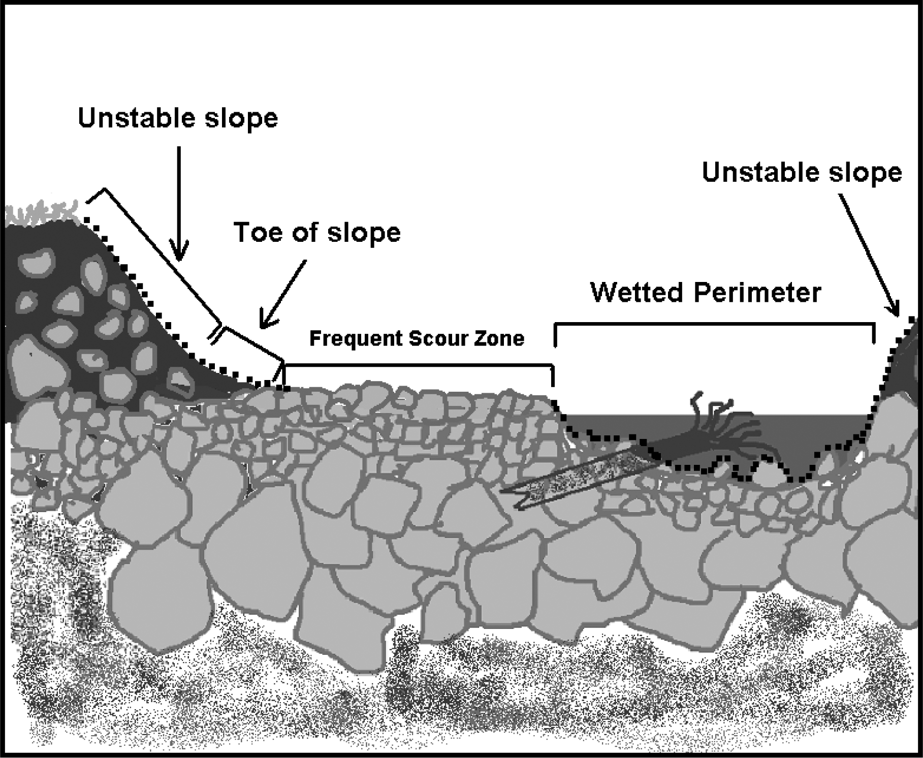 |
Figure 1: Cross section of a typical body of water, showing areas where excavation is not permitted under rules for mineral prospecting without timing restrictions. Dashed lines indicate areas where excavation is not permitted.
(iii) A person may work in only one excavation site at a time. However, a person may use a second excavation site as a settling pond. Multiple persons may work within a single excavation site.
(iv) When collecting or excavating aggregate, a person may not stand within, or allow aggregate to enter, the wetted perimeter.
(v) A person must fill all excavation sites and level all tailing piles before moving to another excavation site or abandoning an excavation site. If a person moves boulders, a person must return them, as well as possible, to their original location.
(vi) A person may not undermine, move, or disturb large woody material embedded in the slopes or located wholly or partially within the wetted perimeter. A person may move large woody material and boulders located entirely within the frequent scour zone, but a person must keep them within the frequent scour zone. A person may not cut large woody material. See Figure 2.
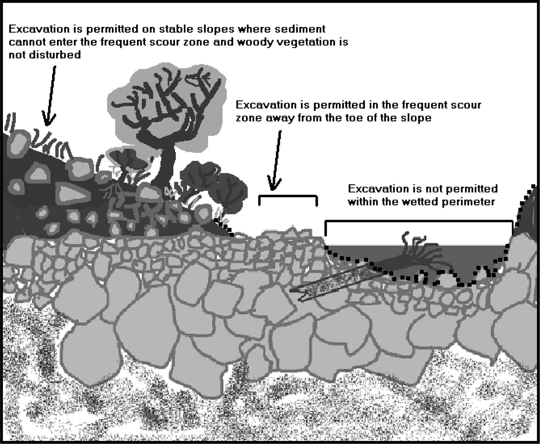 |
Figure 2: Permitted and prohibited excavation sites in a typical body of water under rules for mineral prospecting without timing restrictions. Dashed lines indicate areas where excavation is not permitted.
(vii) A person may not undermine, cut, or disturb live, rooted woody vegetation of any kind.
(viii) A person may not excavate, collect, or remove aggregate from the toe of the slope. A person also may not excavate, collect, or remove aggregate from an unstable slope or any slope that delivers, or might deliver sediment to the wetted perimeter or frequent scour zone. See Figures 3 and 4.
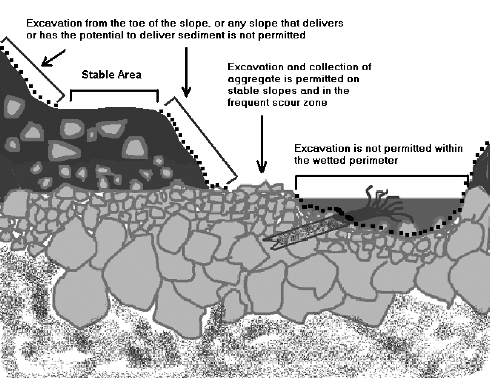 |
Figure 3: Limits on excavating, collecting, and removing aggregate on stream banks.
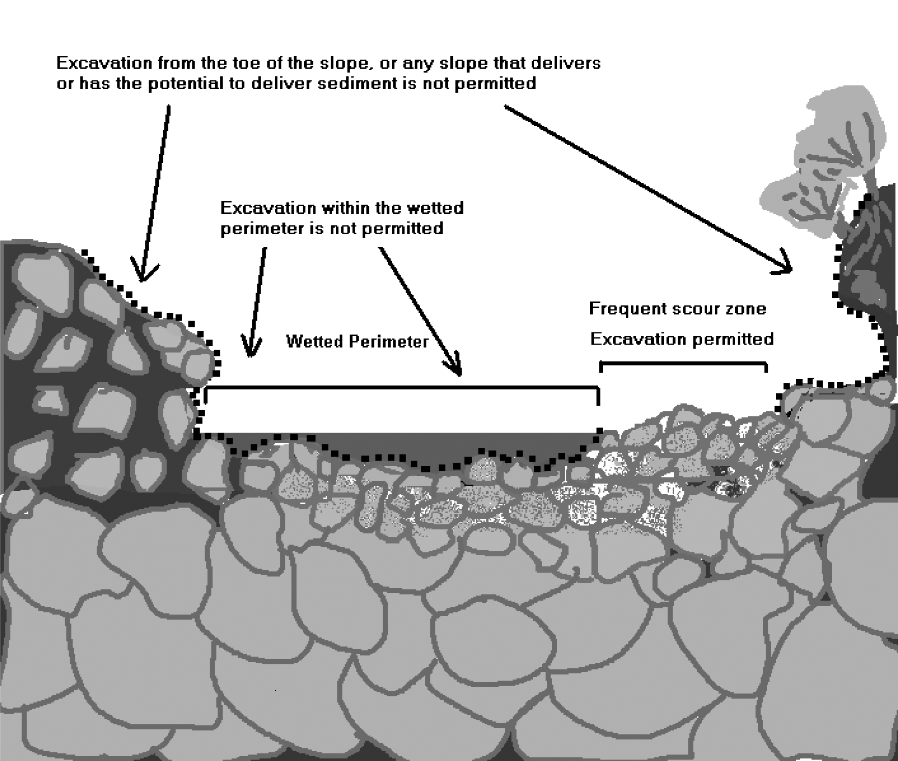 |
Figure 4: Excavating, collecting and removing aggregate within the wetted perimeter is not permitted.
(g) Processing aggregate:
(i) A person may stand within the wetted perimeter when processing aggregate with pans, spiral wheels, and sluices.
(ii) A person may not stand on or process directly on redds, or disturb incubating fish life. A person may not allow tailings or visible sediment plumes (visibly muddy water) to enter redds or areas where fish life are located within the bed.
(iii) A person may not level or disturb tailing piles that remain within the wetted perimeter after processing aggregate.
(iv) If a person collected or excavated aggregate outside of the frequent scour zone, a person must classify it at the collection or excavation site before processing.
(v) When using a sluice, a person may process only classified aggregate within the wetted perimeter.
(vi) The maximum width of a sluice, measured at its widest point, including attachments, must not exceed twenty-five percent of the width of the wetted perimeter at the point of placement.
(vii) A person may process with a sluice only in areas within the wetted perimeter that are composed mainly of boulders and bedrock. A person must separate sluice locations by at least fifty feet. A person may not place structures within the wetted perimeter to check or divert the water flow.
(viii) A person may operate mini high-bankers or other concentrators only outside the wetted perimeter. A person may not allow visible sediment or muddy water to enter the wetted perimeter. A second excavation site may be used as a settling pond.
(ix) As provided in RCW 77.57.010 and 77.57.070, any device a person uses for pumping water from fish-bearing waters must be equipped with a fish guard to prevent fish from entering the pump intake. A person must screen the pump intake with material that has openings no larger than five sixty-fourths inch for square openings, measured side to side, or three thirty-seconds inch diameter for round openings, and the screen must have at least one square inch of functional screen area for every gallon per minute (gpm) of water drawn through it. For example, a one hundred gpm-rated pump would require a screen with a surface area of at least one hundred square inches.
(x) A person may not excavate, collect, remove, or process aggregate within four hundred feet of any fishway, dam, or hatchery water intake.
(xi) A person may not disturb existing habitat improvement structures or stream channel improvements.
(xii) All equipment fueling and servicing must be done so that petroleum products do not enter the wetted perimeter or frequent scour zone. If a petroleum sheen or spill is observed, a person must immediately stop work, remove the equipment from the body of water, and contact the Washington military department emergency management division. A person may not return the equipment to the water until the problem is corrected. A person must store fuel and lubricants outside the frequent scour zone, and in the shade when possible.
(xiii) If at any time, as a result of project activities, a person observes a fish kill or fish life in distress, a person must immediately cease operations and notify the department and the Washington military department emergency management division of the problem. A person may not resume work until the department gives approval. The department will require additional measures to mitigate the prospecting impacts.
(5) Mineral prospecting in fresh waters with timing restrictions:
(a) A person may mineral prospect in fresh waters of the state only during the times and with the mineral prospecting equipment limitations identified in subsection (7) of this section. A person must have the Gold and Fish pamphlet on the job site and comply with the provisions listed below.
(b) When mineral prospecting with timing restrictions, a person may use only hand-held mineral prospecting tools and the following mineral prospecting equipment:
(i) Pans;
(ii) Spiral wheels;
(iii) Sluices, concentrators, rocker boxes, and high-bankers with riffle areas totaling ten square feet or less, including ganged equipment;
(iv) Suction dredges that have suction intake nozzles with inside diameters that should be five inches or less, but must be no greater than five and one-quarter inches to account for manufacturing tolerances and possible deformation of the nozzle. The inside diameter of the dredge hose attached to the nozzle may be no greater than one inch larger than the nozzle size. See Figure 5.
 |
Figure 5: Dredge intake nozzle
(v) Power sluice/suction dredge combinations that have riffle areas totaling ten square feet or less, including ganged equipment; suction intake nozzles with inside diameters that should be five inches or less, but must be no greater than five and one-quarter inches to account for manufacturing tolerances and possible deformation of the nozzle; and pump intake hoses with inside diameters of four inches or less. The inside diameter of the dredge hose attached to the suction intake nozzle may be no greater than one inch larger than the nozzle size. See Figure 5; and
(vi) High-bankers and power sluices that have riffle areas totaling ten square feet or less, including ganged equipment, and pump intake hoses with inside diameters of four inches or less.
(c) The widest point of a sluice, including attachments, must not exceed twenty-five percent of the width of the wetted perimeter at the point of placement.
(d) The suction intake nozzle and hose of suction dredges and power sluice/suction dredge combinations must not exceed the diameters allowed in the listing for the stream or stream reach where a person is operating, as identified in subsection (7) of this section.
(e) A person may not use vehicle-mounted winches. A person may use one motorized winch and one hand-operated winch to move boulders and large woody material that is not embedded, and additional cables, chains, or ropes to stabilize them.
(f) Equipment separation:
(i) A person may use hand-held mineral prospecting tools; pans; spiral wheels; or sluices, mini rocker boxes, or mini high-bankers with riffle areas totaling three square feet or less, including ganged equipment, as close to other mineral prospecting equipment as desired.
(ii) When operating any sluice or rocker box with a riffle area larger than three square feet (including ganged equipment), suction dredge, power sluice/suction dredge combination, high-banker, or power sluice within the wetted perimeter, a person's equipment must be at least two hundred feet from all others also operating this type of equipment. This separation is measured as a radius from the center of the equipment the person is operating. A person may locate this equipment closer than two hundred feet if only one piece of equipment is actually operating within that two hundred foot radius. See Figure 6.
(iii) When operating any sluice or rocker box with a riffle area larger than three square feet (including ganged equipment), suction dredge, power sluice/suction dredge combination, high-banker, or power sluice outside of the wetted perimeter that discharges tailings or wastewater to the wetted perimeter, a person's equipment must be at least two hundred feet from all others also operating this type of equipment. This separation is measured as a radius from the center of the equipment the person is operating. A person may locate this equipment closer than two hundred feet if only one piece of equipment is actually operating within that two hundred-foot radius. See Figure 6.
 |
Figure 6: Equipment separation requirement.
(g) As provided in RCW 77.57.010 and 77.57.070, any device a person uses for pumping water from fish-bearing waters must be equipped with a fish guard to prevent fish from entering the pump intake. A person must screen the pump intake with material that has openings no larger than five sixty-fourths inch for square openings, measured side to side, or three thirty-seconds inch diameter for round openings, and the screen must have at least one square inch of functional screen area for every gallon per minute (gpm) of water drawn through it. For example, a one hundred gpm-rated pump would require a screen with a surface area of at least one hundred square inches.
(h) All equipment fueling and servicing must be done so that petroleum products do not enter the wetted perimeter or frequent scour zone. If a petroleum sheen or spill is observed, a person must immediately stop work, remove the equipment from the body of water, and contact the Washington military department emergency management division. A person may not return the equipment to the water until the problem is corrected. A person must store fuel and lubricants outside the frequent scour zone, and in the shade when possible.
(i) A person may work within the wetted perimeter or frequent scour zone only from one-half hour before official sunrise to one-half hour after official sunset. If a person's mineral prospecting equipment exceeds one-half the width of the wetted perimeter of the stream, a person must remove the equipment from the wetted perimeter or move it so that at least fifty percent of the wetted perimeter is free of equipment from one-half hour after official sunset to one-half hour before official sunrise.
(j) A person may not excavate, collect, remove, or process aggregate within four hundred feet of any fishway, dam, or hatchery water intake.
(k) A person must not disturb existing habitat improvement structures or stream channel improvements.
(l) A person may not undermine, move, or disturb large woody material embedded in the slopes or located wholly or partially within the wetted perimeter. A person may move large woody material and boulders located entirely within the frequent scour zone, but a person must keep them within the frequent scour zone. A person may not cut large woody material.
(m) A person may not undermine, cut, or disturb live, rooted woody vegetation of any kind.
(n) A person may work in only one excavation site at a time. However, a person may use a second excavation site as a settling pond. Multiple individuals may work within a single excavation site.
(o) A person must fill all excavation sites and level all tailing piles before moving to another excavation site or abandoning an excavation site.
(p) A person may not excavate, collect, or remove aggregate from the toe of the slope. A person also may not excavate, collect, or remove aggregate from an unstable slope or any slope that delivers, or might deliver, sediment to the wetted perimeter or frequent scour zone. See Figures 7 and 8.
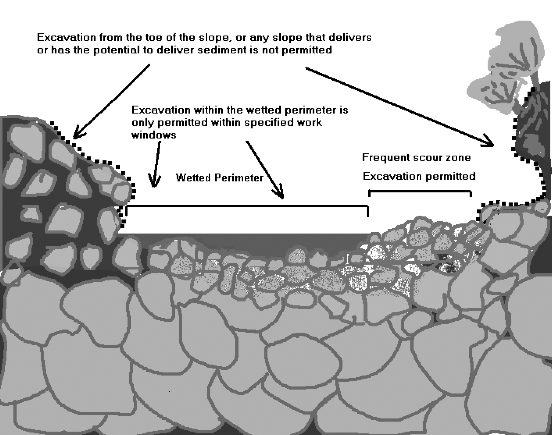 |
Figure 7: Cross section of a typical body of water showing unstable slopes, stable areas, and permitted or prohibited excavation sites under rules for mineral prospecting with timing restrictions. Dashed line indicates areas where excavation is not permitted.
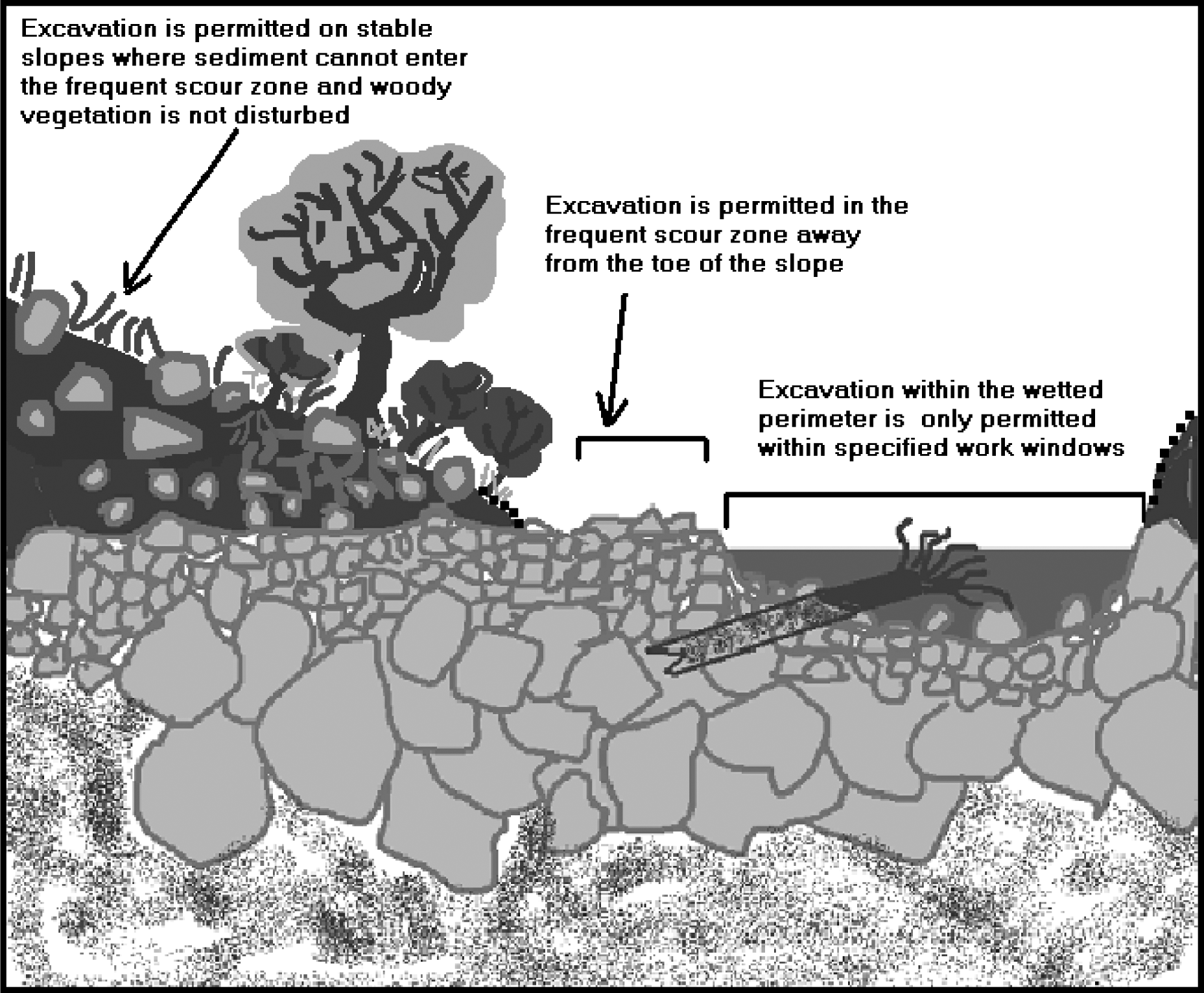 |
Figure 8: Cross section of a typical body of water showing unstable slopes, stable areas, and permitted or prohibited excavation sites under rules for mineral prospecting with timing restrictions. Dashed line indicates areas where excavation is not permitted.
(q) A person may partially divert a body of water into mineral prospecting equipment. However, at no time may the diversion structure be greater than fifty percent of the width of the wetted perimeter, including the width of the equipment. A person may not divert the body of water outside of the wetted perimeter.
(r) A person may use materials only from within the wetted perimeter, or artificial materials from outside the wetted perimeter, to construct the diversion structure by hand. Before abandoning the site, a person must remove artificial materials used to construct a diversion structure and restore the site to its approximate original condition.
(s) A person may process aggregate collected from the frequent scour zone:
(i) At any location if a person uses pans; spiral wheels; mini rocker boxes; mini high-bankers; or sluices or other concentrators with riffle areas three square feet or less, including ganged equipment.
(ii) Only in the frequent scour zone or upland areas landward of the frequent scour zone if a person uses power sluice/suction dredge combinations, high-bankers, or power sluices with riffle areas totaling ten square feet or less, including ganged equipment; or sluices or rocker boxes that have riffle areas larger than three, but less than ten square feet, including ganged equipment. A person may not discharge tailings to the wetted perimeter when using this equipment. However, a person may discharge wastewater to the wetted perimeter if its entry point into the wetted perimeter is at least two hundred feet from any other wastewater discharge entry point.
(t) A person may process aggregate collected from upland areas landward of the frequent scour zone:
(i) At any location if a person uses pans; spiral wheels; or sluices, concentrators, mini rocker boxes, and mini high-bankers with riffle areas totaling three square feet or less, including ganged equipment. A person must classify the aggregate at the excavation site before processing with this equipment within the wetted perimeter or frequent scour zone.
(ii) Only at an upland location landward of the frequent scour zone if a person uses power sluice/suction dredge combinations; high-bankers; power sluices; or rocker boxes. A person may not allow tailings or wastewater to enter the wetted perimeter or frequent scour zone.
(iii) Within the wetted perimeter or frequent scour zone if a person uses a sluice with a riffle area greater than three square feet. A person must classify the aggregate at the excavation site prior to processing with a sluice with a riffle area exceeding three square feet.
(u) A person may use pressurized water only for crevicing or for redistributing dredge tailings within the wetted perimeter. No other use of pressurized water is permitted.
(v) A person may conduct crevicing in the wetted perimeter, in the frequent scour zone, or landward of the frequent scour zone. The hose connecting fittings of pressurized water tools used for crevicing may not have an inside diameter larger than three-quarters of an inch. If a person crevices landward of the frequent scour zone, no sediment or wastewater may be discharged into the wetted perimeter or the frequent scour zone.
(w) A person must avoid areas containing live freshwater mussels. If a person encounters live mussels during excavation, a person must relocate the operation.
(x) A person may not disturb redds. If a person observes or encounters redds or actively spawning fish when collecting or processing aggregate, a person must relocate the operation.
(y) If at any time, as a result of project activities, a person observes a fish kill or fish life in distress, a person must immediately stop operations and notify the department and the Washington military department emergency management division of the problem. A person may not resume work until the department gives approval. The department will require additional measures to mitigate the prospecting impacts.
(6) Mineral prospecting on ocean beaches:
(a) A person may mineral prospect year-round on ocean beaches of the state. A person must follow the rules listed below, and must have the Gold and Fish pamphlet on the job site when working on ocean beaches of the state, except as noted in this subsection.
(b) A person may mineral prospect only between the line of ordinary high tide and the line of extreme low tide on beaches within the Seashore Conservation Area set under RCW 79A.05.605 and managed by Washington state parks and recreation commission.
(c) No written or pamphlet HPA is required to mineral prospect south of the Copalis River, if a person operates landward of the upper limit of ghost shrimp burrowing in the beach; waterward of the ordinary high tide line; and a person does not use fresh water from fish-bearing streams during operations. See Figure 9.
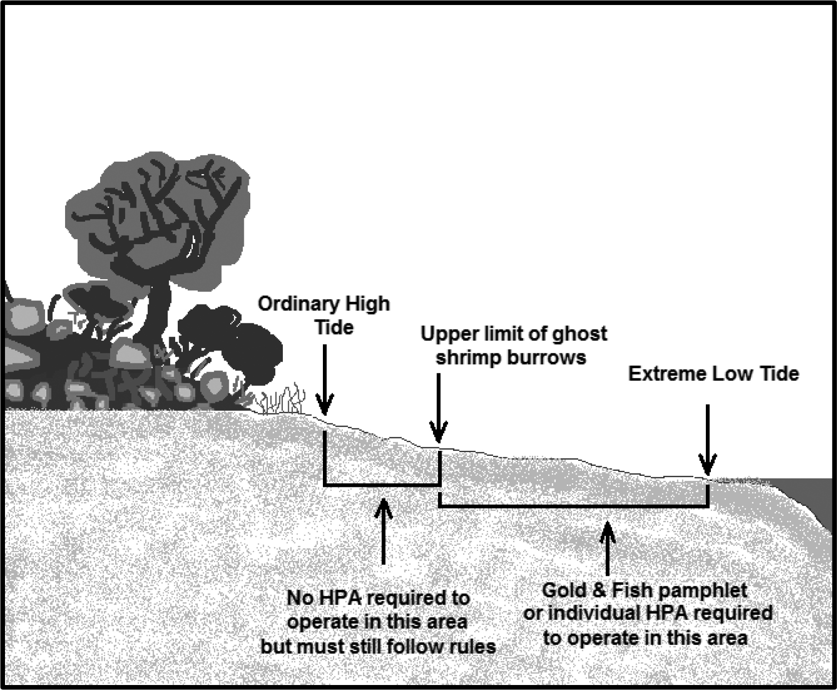 |
Figure 9. Beach area where no written or pamphlet HPA is required.
(d) A person may use only hand-held mineral prospecting tools and the following mineral prospecting equipment:
(i) Pans;
(ii) Spiral wheels;
(iii) Sluices, concentrators, rocker boxes, and high-bankers with riffle areas totaling ten square feet or less, including ganged equipment;
(iv) Suction dredges that have suction intake nozzles with inside diameters that should be five inches or less, but must be no greater than five and one-quarter inches to account for manufacturing tolerances and possible deformation of the nozzle. The inside diameter of the dredge hose attached to the nozzle may be no greater than one inch larger than the nozzle size;
(v) Power sluice/suction dredge combinations that have riffle areas totaling ten square feet or less, including ganged equipment; suction intake nozzles with inside diameters that should be five inches or less, but must be no greater than five and one-quarter inches to account for manufacturing tolerances and possible deformation of the nozzle; and pump intake hoses with inside diameters of four inches or less. The inside diameter of the dredge hose attached to the suction intake nozzle may be no greater than one inch larger than the nozzle size; and
(vi) High-bankers and power sluices that have riffle areas totaling ten square feet or less, including ganged equipment, and pump intake hoses with inside diameters of four inches or less.
(e) When operated in fish-bearing freshwater streams, the widest point of a sluice, including attachments, must not exceed twenty-five percent of the width of the wetted perimeter at the point of placement.
(f) A person may not use vehicle-mounted winches. A person may use one motorized winch and one hand-operated winch to move boulders and large woody material that is not embedded, and additional cables, chains, or ropes to stabilize them.
(g) Under RCW 77.57.010 and 77.57.070, any device a person uses for pumping water from fish-bearing waters must be equipped with a fish guard to prevent fish from entering the pump intake. A person must screen the pump intake with material that has openings no larger than five sixty-fourths inch for square openings, measured side to side, or three thirty-seconds inch diameter for round openings, and the screen must have at least one square inch of functional screen area for every gallon per minute (gpm) of water drawn through it. For example, a one hundred gpm-rated pump would require a screen with a surface area of at least one hundred square inches.
(h) All equipment fueling and servicing must be done so that petroleum products do not enter the wetted perimeter. If a petroleum sheen or spill is observed, a person must immediately stop work, remove the equipment from the body of water and beach, and contact the Washington military department emergency management division. A person may not return the equipment to the water or beach until the problem is corrected. A person must store fuel and lubricants away from the water inside a vehicle or landward of the beach, and in the shade when possible.
(i) A person may work only from one-half hour before official sunrise to one-half hour after official sunset. If a person uses mineral prospecting equipment in a fish-bearing freshwater stream and the equipment exceeds one-half the width of the wetted perimeter of the stream, a person must remove the equipment from the wetted perimeter or move it so that at least fifty percent of the wetted perimeter is free of equipment from one-half hour after official sunset to one-half hour before official sunrise.
(j) A person may not undermine, cut, disturb, or move large woody material or woody debris jams.
(k) A person may work in only one excavation site at a time. However, a person may use a second excavation site as a settling pond. Multiple persons may work within a single excavation site.
(l) A person must backfill all trenches, depressions, or holes created in the beach during project activities before moving to another excavation site (except during use as a settling pond) or leaving an excavation site.
(m) A person may partially divert a body of water into mineral prospecting equipment. However, at no time may the diversion structure be greater than fifty percent of the width of the wetted perimeter of a fish-bearing freshwater stream, including the width of the equipment. A person may not divert the body of water outside of the wetted perimeter.
(n) A person may use materials only from within the wetted perimeter, or artificial materials from outside the wetted perimeter, to construct the diversion structure by hand. Before abandoning the site, a person must remove artificial materials used to construct a diversion structure and restore the site to its approximate original condition.
(o) A person may use pressurized water only for redistributing dredge tailings within the wetted perimeter. No other use of pressurized water is permitted.
(p) A person may not disturb live razor clams or other shellfish within the bed. If a person observes or encounters live razor clams or other shellfish during excavation, the person must relocate the operation.
(q) If at any time, as a result of project activities, a person observes a fish kill or fish life in distress, a person must immediately stop operations and notify the department, and the Washington military department emergency management division of the problem. A person may not resume work until the department gives approval. The department will require additional measures to mitigate the prospecting impacts.
(7) Authorized work times and mineral prospecting equipment restrictions by specific state waters for mineral prospecting and placer mining projects:
(a) A person may conduct mineral prospecting and placer mining under subsections (5) and (6) of this section only in the state waters, with the equipment restrictions, and during the times specified in the following table of authorized work times.
(b) The general work time for a county applies to all state waters within that county, unless otherwise indicated in the table.
(c) The work time for state waters identified in the table of authorized work times applies to all its tributaries, unless otherwise indicated. Some state waters occur in multiple counties. Check the table for the county in which mineral prospecting or placer mining is to be conducted to determine the work time for that waterbody.
(d) Where a tributary is identified as a boundary, that boundary is the line perpendicular to the receiving stream that is projected from the most upstream point of the tributary mouth to the opposite bank of the receiving stream. See Figure 10.
(e) Mineral prospecting and placer mining within waterbodies identified in the table of authorized work times as "submit application" are not authorized under the Gold and Fish pamphlet. A person must obtain a written individual HPA to work in these waterbodies.
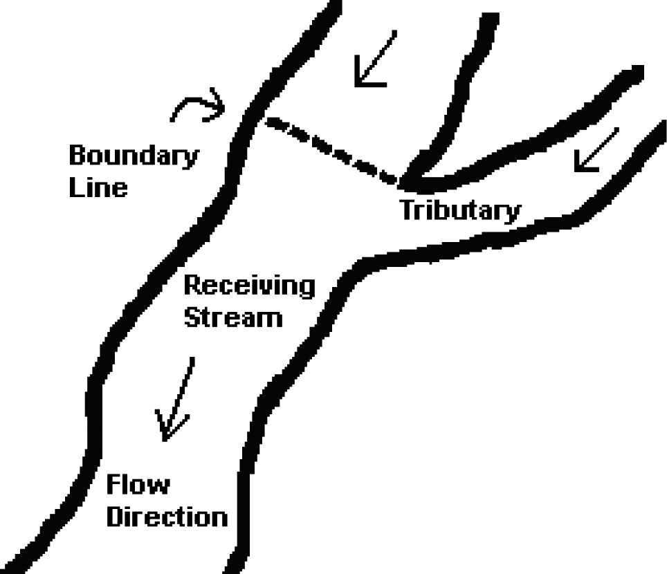 |
Figure 10: Where the boundary is located if a tributary listed as a boundary.
(f) Mineral prospecting using mineral prospecting equipment that has suction intake nozzles with inside diameters that should be four inches or less, but must be no greater than four and one-quarter inches to account for manufacturing tolerances and possible deformation of the nozzle, is authorized only in the state waters identified in the table of authorized work times, and any tributaries to them, unless otherwise indicated in the table. The inside diameter of the dredge hose attached to the nozzle may be no greater than one inch larger than the nozzle size.
(g) Mineral prospecting using mineral prospecting equipment that has suction intake nozzles with inside diameters that should be five inches or less, but must be no greater than five and one-quarter inches to account for manufacturing tolerances and possible deformation of the nozzle is authorized only in the state waters specifically identified in the table of authorized work times. The inside diameter of the dredge hose attached to the nozzle may be no greater than one inch larger than the nozzle size. A person may use only mineral prospecting equipment with suction intake nozzle inside diameters of four and one-quarter inches or less in tributaries of these state waters. The inside diameter of the dredge hose attached to the nozzle may be no greater than one inch larger than the nozzle size.
Table 2
Authorized Work Times and Mineral Prospecting Equipment Restrictions by Specific State Waters for Mineral Prospecting and Placer Mining Projects
Washington Counties and State Waters (Water Resource Inventory Area (WRIA) in parentheses) |
Mineral Prospecting is Allowed Only Between These Dates |
State Waters (and tributaries, unless otherwise indicated) in Which a Person May Use Mineral Prospecting Equipment With a Four and One-Quarter Inch Maximum Suction Intake Nozzle Inside Diameter |
State Waters (NOT including tributaries) in Which a Person May Use Mineral Prospecting Equipment With a Five and One-Quarter Inch Maximum Suction Intake Nozzle Inside Diameter |
Adams County |
July 1 - October 31 |
X |
– |
Crab Creek (41.0002) |
July 16 - February 28 |
X |
X |
Esquatzel Creek (36.MISC) |
June 1 - February 28 |
X |
X |
Palouse River (34.0003) |
July 16 - February 28 |
X |
X |
Asotin County |
July 16 - September 15 |
X |
– |
Snake River (35.0002) |
See Below |
– |
– |
Alpowa Creek (35.1440) |
July 16 - December 15 |
X |
– |
Asotin Creek (35.1716) |
July 16 - August 15 |
X |
– |
Couse Creek (35.2147) |
July 16 - December 15 |
X |
– |
Grande Ronde River (35.2192) |
July 16 - September 15 |
X |
X |
Ten Mile Creek (35.2100) |
July 16 - December 15 |
X |
– |
Benton County |
June 1 - September 30 |
X |
– |
Columbia River |
See Below |
– |
– |
Glade Creek (31.0851) |
August 1 - September 30 |
X |
– |
Yakima River (37.0002) |
June 1 - September 15 |
X |
X |
Amon Wasteway (37.0009) |
June 1 - September 30 |
X |
– |
Corral Creek (37.0002) |
June 1 - September 30 |
X |
– |
Spring Creek (37.0205) |
June 1 - September 30 |
X |
– |
Chelan County |
July 16 - August 15 |
X |
– |
Columbia River |
See Below |
– |
– |
Antoine Creek (49.0294) - Mouth to falls at river mile 1.0 |
July 1 - February 28 |
X |
– |
Antoine Creek (49.0294) - Upstream of falls at river mile 1.0 |
July 1 - March 31 |
X |
– |
Chelan River (47.0052) - Mouth to Chelan Dam |
July 16 - September 30 |
X |
X |
Colockum Creek (40.0760) |
July 1 - October 31 |
X |
– |
Entiat River (46.0042) - Mouth to Entiat Falls |
July 16 - July 31 |
X |
X |
Entiat River (46.0042) - Upstream of Entiat Falls |
July 16 - March 31 |
X |
– |
Crum Canyon (46.0107) |
July 16 - March 31 |
X |
– |
Mad River (46.0125) |
July 16 - July 31 |
X |
– |
Indian Creek (46.0128) |
July 16 - February 28 |
X |
– |
Lake Chelan (47.0052) |
Submit Application |
– |
– |
Railroad Creek (47.0410) |
July 16 - September 30 |
X |
– |
Stehekin River (47.0508) |
Submit Application |
– |
– |
Twenty-Five Mile Creek (47.0195) |
July 16 - September 30 |
X |
– |
Other Lake Chelan tributaries outside of North Cascades National Park |
July 1 - August 15 |
X |
– |
Other Lake Chelan tributaries within North Cascades National Park |
Submit Application |
– |
– |
Number 1 Canyon (45.0011) |
July 1 - February 28 |
X |
– |
Number 2 Canyon (45.0012) |
July 1 - February 28 |
X |
– |
Squilchuck Creek (40.0836) - Mouth to South Wenatchee Avenue |
July 1 - September 30 |
X |
– |
Squilchuck Creek (40.0836) - Upstream of South Wenatchee Avenue |
July 1 - February 28 |
X |
– |
Stemilt Creek (40.0808) - Mouth to falls |
July 1 - September 30 |
X |
– |
Stemilt Creek (40.0808) - Upstream of falls |
July 1 - February 28 |
X |
– |
Wenatchee River (45.0030) - Mouth to Hwy 2 Bridge in Leavenworth |
July 15 - September 30 |
X |
X |
Wenatchee River (45.0030) - Hwy 2 Bridge in Leavenworth to Lake Wenatchee |
July 15 - August 15 |
X |
X |
Beaver Creek (45.0751) |
July 1 - September 30 |
X |
– |
Chiwaukum Creek (45.0700) |
July 1 - July 31 |
X |
– |
Chiwawa River (45.0759) - Mouth to Phelps Creek |
July 1 - July 31 |
X |
X |
Chiwawa River (45.0759) - Upstream of Phelps Creek |
July 1 - July 31 |
X |
– |
Deep Creek (45.0764) |
July 1 - February 28 |
X |
– |
Phelps Creek (45.0875) |
July 16 - August 15 |
X |
– |
Icicle Creek (45.0474) - Mouth to Johnny Creek |
July 1 - July 31 |
X |
X |
Icicle Creek (45.0474) - Upstream of Johnny Creek |
July 1 - July 31 |
X |
– |
Fourth of July Creek (45.0525) |
July 1 - February 28 |
X |
– |
Lake Wenatchee (45.0030) |
Submit Application |
– |
– |
Little Wenatchee (45.0985) - Mouth to Wilderness Boundary |
July 1 - July 31 |
X |
X |
Little Wenatchee (45.0985) - Upstream of Wilderness Boundary |
Submit Application |
– |
– |
White River (45.1116) - Mouth to White River Falls |
July 1 - July 31 |
X |
X |
White River (45.1116) - Upstream of White River Falls |
July 1 - February 28 |
X |
– |
Nason Creek (45.0888) |
July 1 - July 31 |
X |
– |
Peshastin Creek (45.0232) - Mouth to Negro Creek |
July 16 - August 15 |
X |
– |
Peshastin Creek (45.0232) - Upstream of Negro Creek |
August 1 - February 28 |
X |
– |
Ingalls Creek (45.0273) - Mouth to Cascade Creek |
Submit Application |
– |
– |
Ingalls Creek (45.0273) - Upstream of Cascade Creek |
July 16 - February 28 |
X |
– |
Negro Creek (45.0323) - Mouth to falls at stream mile 2.9 |
Submit Application |
– |
– |
Negro Creek (45.0323) - Upstream of falls at stream mile 2.9 |
July 16 - February 28 |
X |
– |
Ruby Creek (45.0318) |
July 16 - February 28 |
X |
– |
Tronson Creek (45.0346) |
August 1 - February 28 |
X |
– |
Scotty Creek (45.0376) |
August 1 - February 28 |
X |
– |
Shaser Creek (45.0365) |
August 1 - February 28 |
X |
– |
Clallam County |
July 16 - September 15 |
X |
– |
Clallam River (19.0129) |
August 1 - August 15 |
X |
– |
Dungeness River (18.0018) |
Submit Application |
– |
– |
Independent Creek (18.MISC) |
August 1 - August 31 |
X |
– |
Elwha River (18.0272) |
August 1 - August 15 |
X |
X |
Hoko River (19.0148) |
August 1 - September 15 |
X |
– |
Jimmycomelately Creek (17.0285) |
August 1 - August 31 |
X |
– |
Lake Ozette (20.0046) |
Submit Application |
– |
– |
Little Quilcene River (17.0076) |
July 16 - August 31 |
X |
– |
Lake Ozette tributaries |
July 16 - September 15 |
X |
– |
Lyre River (19.0031) |
August 1 - September 15 |
X |
– |
McDonald Creek (18.0160) |
August 1 - September 15 |
X |
– |
Morse Creek (18.0185) |
August 1 - August 15 |
X |
– |
Ozette River (20.0046) |
July 16 - September 15 |
X |
– |
Pysht River (19.0113) |
August 1 - September 15 |
X |
– |
Quillayute River (20.0096, 20.0162, 20.0175) |
August 1 - August 15 |
X |
X |
Bogachiel River (20.0162) |
Submit Application |
– |
– |
Calawah River (20.0175) |
August 1 - August 15 |
X |
X |
Salmon Creek (17.0245) |
July 16 - August 31 |
X |
– |
Sekiu River (19.0203) |
August 1 - September 15 |
X |
– |
Snow Creek (17.0219) |
July 16 - August 31 |
X |
– |
Sol Duc River (20.0096) |
Submit Application |
– |
– |
Lake Pleasant (20.0313) |
Submit Application |
– |
– |
Lake Pleasant tributaries |
July 16 - September 15 |
X |
– |
Sooes River (20.0015) |
July 16 - September 15 |
X |
– |
Clark County |
July 16 - September 30 |
– |
– |
Columbia River |
See Below |
– |
– |
Lacamas Creek (28.0160) - Mouth to dam |
August 1 - August 31 |
X |
– |
Lacamas Creek (28.0160) - Upstream of dam |
August 1 - September 30 |
X |
– |
Lewis River (27.0168) |
August 1 - August 15 |
X |
X |
East Fork Lewis River (27.0173) - Mouth to Lucia Falls |
August 1 - August 15 |
X |
X |
East Fork Lewis River (27.0173) - Lucia Falls to Sunset Falls |
August 1 - February 28 |
X |
X |
East Fork Lewis River (27.0173) - Upstream of Sunset Falls |
August 1 - February 28 |
X |
– |
Lake River (28.0020) |
January 1 - December 31 |
X |
X |
Burnt Bridge Creek (28.0143) |
August 1 - August 31 |
X |
– |
Salmon Creek (28.0059) |
August 1 - August 31 |
X |
– |
Whipple Creek (28.0038) |
August 1 - September 30 |
X |
– |
North Fork Lewis River (27.0334) - Confluence of East Fork to Merwin Dam |
August 1 - August 15 |
X |
X |
Cedar Creek (27.0339) |
August 1 - September 15 |
X |
– |
North Fork Lewis River (27.0334) - Merwin Dam to Lower Falls |
July 16 - August 15 |
X |
X |
Canyon Creek (27.0442) |
July 16 - February 28 |
X |
– |
North Fork Lewis River (27.0168) - Upstream of Lower Falls |
July 16 - August 15 |
X |
X |
Washougal River (28.0159) - Mouth to headwaters |
August 1 - August 31 |
X |
X |
Columbia County |
July 16 - September 30 |
X |
– |
Touchet River (32.0097) |
August 1 - August 15 |
X |
X |
Grande Ronde River tributaries (35.2192) |
July 16 - August 15 |
X |
– |
North Fork Touchet/Wolf Fork (32.0761) |
Submit Application |
– |
– |
South Fork Touchet (32.0708) |
Submit Application |
– |
– |
Tucannon River (35.0009) |
July 16 - August 15 |
X |
X |
Walla Walla River (32.0008) - Mouth to Oregon state line |
July 16 - September 15 |
X |
X |
Mill Creek (32.1436) - Mouth to Oregon state line |
August 1 - August 15 |
X |
– |
Cowlitz County |
July 16 - September 30 |
X |
– |
Chehalis River (22.0190/23.0190) - South Fork Chehalis River - Mouth to Fisk Falls |
August 1 - August 31 |
X |
X |
Chehalis River (22.0190/23.0190) - South Fork Chehalis River - Upstream of Fisk Falls |
August 1 - August 31 |
X |
– |
Columbia River |
See Below |
– |
– |
Abernathy Creek (25.0297) |
July 16 - September 15 |
X |
– |
Burke Creek (27.0148) |
August 1 - August 31 |
X |
– |
Burris Creek (27.0151) |
August 1 - August 31 |
X |
– |
Bybee Creek (27.0142) |
August 1 - August 31 |
X |
– |
Canyon Creek (27.0147) |
August 1 - August 31 |
X |
– |
Coal Creek (25.0340) |
July 16 - September 15 |
X |
– |
Clark Creek (25.0371) |
August 1 - August 31 |
X |
– |
Cowlitz River (26.0002) - Mouth to barrier dam at river mile 49.5 |
July 16 - August 15 |
X |
X |
Coweeman River (26.0003) - Mouth to Baird Creek |
August 1 - August 31 |
X |
X |
Coweeman River (26.0003) - Upstream of Baird Creek |
August 1 - August 31 |
X |
– |
Cowlitz River (26.0002) - Tributaries below barrier dam to mouth |
July 16 - September 30 |
X |
– |
Owl Creek (26.1441) |
July 16 - September 15 |
X |
– |
Toutle River (26.0227) |
July 16 - August 15 |
X |
X |
North Fork Toutle River (26.0314) - Mouth to Debris Dam |
July 16 - August 15 |
X |
X |
North Fork Toutle River (26.0314) - Upstream of Debris Dam |
July 16 - August 15 |
X |
– |
Green River (26.0323) - Mouth to Shultz Creek |
July 16 - September 30 |
X |
X |
Green River (26.0323) - Upstream of Shultz Creek |
July 16 - September 30 |
X |
– |
South Fork Toutle (26.0248) - Mouth to Bear Creek |
July 16 - September 15 |
X |
X |
South Fork Toutle (26.0248) - Upstream of Bear Creek |
July 16 - September 15 |
X |
– |
Tributaries to Silver Lake |
July 16 - September 30 |
X |
– |
Germany Creek (25.0313) |
July 16 - September 15 |
X |
– |
Kalama River (27.0002) - Mouth to Kalama Falls |
August 1 - August 15 |
X |
X |
Kalama River (27.0002) - Upstream of Kalama Falls |
August 1 - August 15 |
X |
– |
Lewis River (27.0168) - Mouth to East Fork Lewis River |
August 1 - August 15 |
X |
X |
North Fork Lewis River (27.0334) - Confluence of East Fork to Merwin Dam |
August 1 - August 15 |
X |
X |
North Fork Lewis River (27.0334) - Merwin Dam to Lower Falls |
July 16 - August 15 |
X |
X |
Mill Creek (25.0284) |
July 16 - September 15 |
X |
– |
Schoolhouse Creek (27.0139) |
August 1 - August 31 |
X |
– |
Douglas County |
July 1 - September 30 |
X |
– |
Columbia River |
See Below |
– |
– |
Douglas Creek Canyon (44.0146) |
May 16 - January 31 |
X |
– |
Foster Creek (50.0065) |
August 1 - April 15 |
X |
– |
McCarteney Creek (44.0002) |
July 1 - February 28 |
X |
– |
Pine/Corbaley Canyon Creek (44.0779) |
September 16 - April 15 |
X |
– |
Rock Island Creek (44.0630) |
July 1 - September 30 |
X |
– |
Ferry County |
July 1 - August 31 |
X |
– |
Columbia River |
See Below |
– |
– |
Kettle River (60.0002) |
June 16 - August 31 |
X |
X |
Boulder Creek (60.0130) - Mouth to Hodgson Road Bridge |
Submit Application |
– |
– |
Boulder Creek (60.0130) - Upstream of Hodgson Road Bridge |
June 16 - February 28 |
X |
– |
Deadman Creek (60.0008) - Mouth to SR395 Crossing |
Submit Application |
– |
– |
Deadman Creek (60.0008) - Upstream of SR395 |
June 16 - February 28 |
X |
– |
Goosmus Creek (60.0254) |
June 16 - February 28 |
X |
– |
Toroda Creek (60.0410) |
July 1 - September 30 |
X |
– |
San Poil River (52.0004) |
June 16 - September 30 |
X |
X |
Granite Creek (52.0099) - Mouth to Powerhouse Dam |
June 16 - September 30 |
X |
– |
Granite Creek (52.0099) - Upstream of Powerhouse Dam |
June 16 - February 28 |
X |
– |
West Fork San Poil River (52.0192) - Mouth to Deep Creek |
June 16 - September 30 |
X |
X |
West Fork San Poil River (52.0192) - Upstream of Deep Creek |
June 16 - September 30 |
X |
– |
Gold Creek (52.0197) |
June 16 - February 28 |
X |
– |
Franklin County |
June 1 - September 30 |
X |
– |
Columbia River |
See Below |
– |
– |
Snake River |
See Below |
– |
– |
Palouse River (34.0003) |
July 16 - February 28 |
X |
X |
North bank tributaries of the lower Snake River between Palouse River and the mouth of the Snake River |
June 16 - October 31 |
X |
– |
Garfield County |
July 16 - September 30 |
X |
– |
Snake River (35.0003) |
See Below |
– |
– |
Alpowa Creek (35.1440) |
July 16 - December 15 |
X |
– |
Asotin Creek (35.1716) |
July 16 - August 15 |
X |
– |
Deadman Creek (35.0688) |
July 16 - December 15 |
X |
– |
Grande Ronde River tributaries (35.2192) |
July 16 - August 15 |
X |
– |
Meadow Creek (35.0689) |
July 16 - December 15 |
X |
– |
Tucannon River (35.0009) - Mouth to Panjab Creek |
July 16 - August 15 |
X |
X |
Tucannon River (35.0009) - Upstream of Panjab Creek |
July 16 - August 15 |
X |
– |
Pataha Creek (35.0123) - Mouth to Pataha Creek |
January 1 - December 31 |
X |
– |
Pataha Creek (35.0123) - Upstream of Pataha Creek |
July 16 - December 31 |
X |
– |
Grant County |
July 1 - October 31 |
X |
– |
Columbia River |
See Below |
– |
– |
Crab Creek (41.0002) |
July 16 - September 15 |
X |
X |
Grays Harbor County |
July 16 - October 15 |
X |
– |
Chehalis River (22.0190/23.0190) - Mouth to Porter Creek |
August 1 - August 31 |
X |
X |
Chehalis River (22.0190/23.0190) - Porter Creek to Fisk Falls |
August 1 - August 15 |
X |
X |
Chehalis River (22.0190/23.0190) - Upstream of Fisk Falls |
August 1 - August 15 |
X |
– |
Cedar Creek (23.0570) |
August 1 - September 30 |
X |
– |
Cloquallum Creek (22.0501) |
August 1 - September 30 |
X |
– |
Porter Creek (23.0543) |
August 1 - September 30 |
X |
– |
Satsop River (22.0360) |
August 1 - August 31 |
X |
X |
Wishkah River (22.0191) |
August 1 - October 15 |
X |
X |
Wynoochee River (22.0260) |
August 1 - September 30 |
X |
X |
Copalis River (21.0767) |
August 1 - October 15 |
X |
X |
Elk River (22.1333) |
July 1 - October 31 |
X |
X |
Hoquiam River (22.0137) |
August 1 - October 15 |
X |
X |
Humptulips River (22.0004) - Mouth to Forks |
August 1 - September 30 |
X |
X |
Humptulips River (22.0004) - Upstream of Forks |
August 1 - September 30 |
X |
– |
Johns River (22.1270) |
August 1 - September 30 |
X |
X |
Moclips River (21.0731) |
August 1 - October 15 |
X |
X |
North River (24.0034) |
August 1 - September 30 |
X |
X |
Queets River (21.0001) |
August 1 - August 15 |
X |
X |
Quinault River (21.0398) |
August 1 - August 15 |
X |
X |
Raft River (21.0337) |
August 1 - October 15 |
X |
X |
Island County |
June 16 - October 15 |
X |
– |
Cavalero Creek (06.0065) |
June 16 - December 15 |
X |
– |
Chapman Creek (06.0070) |
June 16 - December 15 |
X |
– |
Crescent Creek (06.0002) |
June 16 - December 15 |
X |
– |
Cultus Creek (06.0026) |
June 16 - March 15 |
X |
– |
Deer Creek (06.0024) |
June 16 - March 15 |
X |
– |
Dugualla Creek (06.0001) |
June 16 - March 15 |
X |
– |
Glendale Creek (06.0025) |
June 16 - December 15 |
X |
– |
Kristoferson Creek (06.0062-06.0063) |
May 1 - December 15 |
X |
– |
Maxwelton Creek (06.0029) |
June 16 - December 15 |
X |
– |
North Bluff Creek (06.0006) |
June 16 - March 15 |
X |
– |
Old Clinton Creek (06.0023) |
June 16 - March 15 |
X |
– |
Jefferson County |
July 16 - October 31 |
X |
– |
Big Quilcene River (17.0012) - Mouth to falls |
July 16 - August 31 |
X |
X |
Big Quilcene River (17.0012) - Falls to Forks |
August 1 - February 28 |
X |
X |
Big Quilcene River (17.0012) - Upstream of Forks |
August 1 - February 28 |
X |
– |
Bogachiel River (20.0162) |
Submit Application |
– |
– |
Chimacum Creek (17.0203) |
July 16 - September 15 |
X |
– |
Donovan Creek (17.0115) |
July 1 - October 15 |
X |
– |
Dosewallips River (16.0442) |
July 16 - August 15 |
X |
– |
Duckabush River (16.0351) |
July 16 - August 15 |
X |
– |
Dungeness River (18.0018) |
August 1 - August 15 |
X |
– |
Elwha River (18.0272) |
August 1 - August 15 |
X |
X |
Goodman Creek (20.0406) |
August 1 - September 15 |
X |
– |
Hoh River (20.0422) |
August 1 - August 15 |
X |
X |
Little Quilcene River (17.0076) |
July 16 - August 31 |
X |
– |
Queets River (21.0001) |
August 1 - August 15 |
X |
X |
Matheny Creek (21.0165) |
August 1 - August 15 |
X |
– |
Sams River (21.0205) |
August 1 - August 15 |
X |
X |
Quinault River (21.0398) |
August 1 - August 15 |
X |
X |
Salmon Creek (17.0245) |
July 16 - August 31 |
X |
– |
Skokomish River (16.0001) |
August 1 - August 31 |
X |
X |
Snow Creek (17.0219) |
July 16 - August 31 |
X |
– |
Tarboo Creek (17.0129) |
August 1 - September 30 |
X |
– |
Thorndyke Creek (17.0170) |
August 1 - October 15 |
X |
– |
King County |
July 16 - September 30 |
X |
– |
Cedar River (08.0299) - Mouth to Forks |
August 1 - August 31 |
X |
X |
Cedar River (08.0299) - Upstream of Forks |
August 1 - August 31 |
X |
– |
Issaquah Creek (08.0178) |
August 1 - August 31 |
X |
– |
Sammamish River (08.0057) |
August 1 - August 31 |
X |
– |
Steele Creek (08.0379) |
July 16 - February 28 |
X |
– |
Green River (Duwamish River) (09.0001) - Mouth to Sawmill Creek |
August 1 - August 31 |
X |
X |
Green River (Duwamish River) (09.0001) - Upstream of Sawmill Creek |
August 1 - August 31 |
X |
– |
Lake Washington tributaries (08.LKWA) |
August 1 - August 31 |
X |
– |
Snoqualmie River (07.0219) - Mouth to Snoqualmie Falls |
August 1 - August 15 |
X |
X |
Snoqualmie River (07.0219) - Snoqualmie Falls to mouth of South Fork |
July 16 - February 28 |
X |
X |
Patterson Creek (07.0376) |
July 16 - September 30 |
X |
– |
Middle Fork Snoqualmie River (07.0219) - Mouth to Taylor Creek |
July 16 - February 28 |
X |
X |
Middle Fork Snoqualmie River (07.0219) - Upstream of Taylor Creek |
July 16 - February 28 |
X |
– |
Goat Creek (07.0754) |
July 16 - February 28 |
X |
– |
North Fork Snoqualmie River (07.0527) - Mouth to Lennox Creek |
July 16 - February 28 |
X |
X |
North Fork Snoqualmie River (07.0527) - Upstream of Lennox Creek |
July 16 - February 28 |
X |
– |
Deep Creek (07.0562) |
July 16 - February 28 |
X |
– |
Illinois Creek (07.0624) |
July 16 - February 28 |
X |
– |
Lennox Creek (07.0596) |
July 16 - February 28 |
X |
– |
Bear Creek (07.0606) |
July 16 - February 28 |
X |
– |
Raging River (07.0384) |
August 1 - September 15 |
X |
X |
South Fork Skykomish River (07.0012) - Mouth to Sunset Falls |
August 1 - August 15 |
X |
X |
South Fork Skykomish River (07.0012) - Upstream of Sunset Falls |
August 1 - August 15 |
X |
– |
Beckler River (07.1413) - Mouth to Boulder Creek |
August 1 - August 15 |
X |
X |
Beckler River (07.1413) - Upstream of Boulder Creek |
July 16 - February 28 |
X |
– |
Rapid River (07.1461) - Mouth to Meadow Creek |
August 1 - August 31 |
X |
X |
Rapid River (07.1461) - Upstream of Meadow Creek |
August 1 - February 28 |
X |
– |
Index Creek (07.1264) - Mouth to Mud Lake Creek |
August 1 - August 31 |
X |
– |
Index Creek (07.1264) - Upstream of Mud Lake Creek including Salmon Creek |
July 16 - February 28 |
X |
– |
Miller River (07.1329) - Mouth to Forks |
August 1 - August 15 |
X |
X |
Miller River (07.1329) - Upstream of Forks |
August 1 - August 15 |
X |
– |
Coney Creek (07.1347) |
July 16 - February 28 |
X |
– |
East Fork Miller River (07.1329) - Mouth to Great Falls Creek |
July 16 - August 15 |
X |
– |
East Fork Miller River (07.1329) - Upstream of Great Falls Creek |
July 16 - February 28 |
X |
– |
Foss River (07.1562) - Mouth to Forks |
July 16 - August 31 |
X |
X |
East Fork Foss River (07.1562) - Mouth to Burn Creek |
July 16 - August 15 |
X |
X |
East Fork Foss River (07.1562) - Upstream of Burn Creek |
July 16 - February 28 |
X |
– |
West Fork Foss River (07.1573) - Mouth to falls at river mile 2.0 |
July 16 - August 31 |
X |
– |
West Fork Foss River (07.1573) - Upstream of falls at river mile 2.0 |
July 16 - February 28 |
X |
– |
West Fork Miller River (07.1335) |
July 16 - February 28 |
X |
X |
Money Creek (07.1300) - Mouth to 0.5 mile upstream of Kimball Creek |
August 1 - August 31 |
X |
– |
Money Creek (07.1300) - Upstream of 0.5 mile upstream of Kimball Creek |
August 1 - February 28 |
X |
– |
Kimball Creek (07.1301) |
August 1 - August 31 |
X |
– |
Tye River (07.0012) - Mouth to Alpine Falls |
August 1 - August 31 |
X |
X |
Tye River (07.0012) - Upstream of Alpine Falls |
July 16 - February 28 |
X |
– |
South Fork Snoqualmie River (07.0467) |
July 16 - February 28 |
X |
X |
Denny Creek (07.0517) |
July 16 - February 28 |
X |
– |
Tolt River (07.0291) - Mouth to Forks |
August 1 - August 31 |
X |
X |
North Fork Tolt River (07.0291) - Mouth to Yellow Creek |
July 16 - September 15 |
X |
X |
North Fork Tolt River (07.0291) - Upstream of Yellow Creek |
July 16 - February 28 |
X |
– |
South Fork Tolt River (07.0302) - Mouth to dam |
July 16 - September 15 |
X |
X |
South Fork Tolt River (07.0302) - Upstream of Tolt Reservoir |
July 16 - February 28 |
X |
– |
Yellow Creek (07.0337) |
July 16 - February 28 |
X |
– |
White River (10.0031) |
July 16 - August 15 |
X |
X |
Greenwater River (10.0122) |
July 16 - August 15 |
X |
X |
Kittitas County |
July 1 - September 30 |
X |
– |
Brushy Creek (40.0612) |
July 1 - February 28 |
X |
– |
Colockum Creek (40.0760) |
July 1 - October 31 |
X |
– |
Quilomene Creek (40.0613) |
July 1 - October 31 |
X |
– |
Stemilt Creek (40.0808) - Upstream of falls |
July 1 - February 28 |
X |
– |
Tarpiscan Creek (40.0723) |
July 1 - February 28 |
X |
– |
Tekiason Creek (40.0686) |
July 1 - February 28 |
X |
– |
Whisky Dick Creek (40.0591) |
July 1 - February 28 |
X |
– |
Yakima River (39.0002) - Roza Dam to Teanaway River |
August 1 - August 31 |
X |
X |
Naches River (38.0003) - Tieton River to Bumping River |
July 1 - August 15 |
X |
X |
Little Naches River (38.0852) - Mouth to Matthew Creek |
July 16 - August 15 |
X |
X |
Little Naches River (38.0852) - Upstream of Matthew Creek |
July 16 - August 15 |
X |
– |
Pileup Creek (38.0932) |
July 16 - August 31 |
X |
– |
Gold Creek (38.MISC) |
July 16 - February 28 |
X |
– |
Swauk Creek (39.1157) |
July 16 - September 30 |
X |
– |
Baker Creek (39.1157) |
July 16 - September 30 |
X |
– |
First Creek (39.1157) |
July 16 - September 30 |
X |
– |
Iron Creek (39.1157) |
July 16 - September 30 |
X |
– |
Williams Creek (39.1157) |
July 16 - September 30 |
X |
– |
Boulder Creek (39.1157) |
July 16 - February 28 |
X |
– |
Cougar Gulch (39.1157) |
July 16 - February 28 |
X |
– |
Lion Gulch (39.1157) |
July 16 - February 28 |
X |
– |
Yakima River (39.0002) - Teanaway River to Easton Dam |
August 1 - August 31 |
X |
X |
Yakima River (39.0002) - Upstream of Easton Dam |
August 1 - August 31 |
X |
X |
Cle Elum River (39.1434) - Mouth to dam |
July 16 - August 31 |
X |
X |
Cle Elum River (39.1434) - Upstream of Cle Elum Dam |
Submit Application |
– |
– |
Big Boulder Creek (39.1434MISC) |
August 1 - February 28 |
X |
– |
Camp Creek (39.1434MISC) |
August 1 - February 28 |
X |
– |
Fortune Creek (39.1434MISC) |
August 1 - August 15 |
X |
– |
South Fork Fortune Creek (39.1434MISC) |
August 1 - February 28 |
X |
– |
Howson Creek (39.1434) |
July 16 - February 28 |
X |
– |
Little Salmon Le Sac Creek (39.1482) |
August 1 - August 15 |
X |
– |
Paris Creek (39.1434MISC) |
August 1 - February 28 |
X |
– |
Salmon Le Sac Creek (39.1520) |
August 1 - February 28 |
X |
– |
Kachess River (39.1739) - Upstream of Lake Kachess |
Submit Application |
– |
– |
Kachess River (39.1739) - Below dam |
July 16 - August 15 |
X |
X |
Box Canyon Creek (39.1765) |
Submit Application |
– |
– |
Mineral Creek (39.1792) |
August 1 - August 15 |
X |
– |
Lake Keechelus (39.1842) tributaries |
July 16 - August 15 |
X |
– |
Gold Creek (Lake Keechelus) (39.1842) |
Submit Application |
– |
– |
Manastash Creek (39.0988) |
July 16 - September 30 |
X |
– |
Naneum Creek (39.0821) |
July 16 - September 30 |
X |
– |
Taneum Creek (39.1081) - Mouth to I-90 |
July 16 - August 31 |
X |
– |
Taneum Creek (39.1157) - Upstream of I-90 |
July 16 - September 30 |
X |
– |
Teanaway River (39.1236) |
July 16 - August 31 |
X |
X |
NF Teanaway River (39.1260) |
Submit Application |
– |
– |
Umtanum Creek (39.0553) |
July 16 - September 30 |
X |
– |
Wenas Creek, Below dam (39.0032) |
July 16 - October 15 |
X |
– |
Wenas Creek, Upstream of Wenas Lake (39.0032) |
July 16 - February 28 |
X |
– |
Other Yakima River tributaries not listed |
July 16 - August 31 |
X |
– |
Kitsap County |
July 16 - October 15 |
X |
– |
Anderson Creek (15.0211) |
August 1 - November 15 |
X |
– |
Barker Creek (15.0255) |
August 1 - September 30 |
X |
– |
Big Beef Creek (15.0389) |
August 1 - August 15 |
X |
– |
Big Scandia Creek (15.0280) |
August 1 - September 30 |
X |
– |
Blackjack Creek (15.0203) |
August 1 - September 30 |
X |
– |
Burley Creek (15.0056) |
August 1 - September 30 |
X |
– |
Chico Creek (15.0229) |
August 1 - October 15 |
X |
– |
Clear Creek (15.0249) |
August 1 - September 30 |
X |
– |
Curley Creek (15.0185) |
August 1 - September 30 |
X |
– |
Dewatto River (15.0420) |
August 1 - August 15 |
X |
– |
Dogfish Creek (15.0285) |
August 1 - August 15 |
X |
– |
Gorst Creek (15.0216) |
August 1 - August 15 |
X |
– |
Grovers Creek (15.0299) |
August 1 - August 31 |
X |
– |
Johnson Creek (15.0387) |
August 1 - October 31 |
X |
– |
Ollala Creek (15.0107) |
August 1 - September 30 |
X |
– |
Ross Creek (15.0209) |
August 1 - November 15 |
X |
– |
Salmonberry Creek (15.0188) |
August 1 - November 30 |
X |
– |
Seabeck Creek (15.0400) |
August 1 - August 15 |
X |
– |
Steele Creek (15.0273) |
August 1 - September 30 |
X |
– |
Tahuya River (15.0446) |
August 1 - August 31 |
X |
X |
Union River (15.0503) |
August 1 - August 31 |
X |
X |
Klickitat County |
July 15 - September 30 |
X |
– |
Alder Creek (31.0459) |
August 1 - September 30 |
X |
– |
Chapman Creek (31.0192) |
August 1 - September 30 |
X |
– |
Glade Creek (31.0851) |
August 1 - September 30 |
X |
– |
Juniper Canyon Creek (31.0378) |
August 1 - September 30 |
X |
– |
Klickitat River (30.0002) - Mouth to Klickitat hatchery |
Submit Application |
– |
– |
Klickitat River (30.0002) - Upstream of Klickitat hatchery |
Submit Application |
– |
– |
Little White Salmon River (29.0131) - Mouth to Cabbage Creek |
July 16 - January 31 |
X |
X |
Little White Salmon River (29.0131) - Upstream of Cabbage Creek |
July 16 - January 31 |
X |
– |
Pine Creek (31.0354) |
August 1 - September 30 |
X |
– |
Rock Creek (31.0014) |
August 1 - September 30 |
X |
– |
Six Prong Creek (31.0465) |
August 1 - September 30 |
X |
– |
White Salmon River (29.0160) - Mouth to Cascade Creek |
July 16 - August 15 |
X |
X |
White Salmon River (29.0160) - Upstream of Cascade Creek |
July 16 - August 15 |
X |
– |
Wood Gulch Creek (31.0263) |
August 1 - September 30 |
X |
– |
Lewis County |
August 1 - September 30 |
X |
– |
Chehalis River (22.0190/23.0190) - Mouth to South Fork Chehalis River |
August 1 - August 15 |
X |
X |
Chehalis River (22.0190/23.0190) - Upstream of South Fork Chehalis River |
August 1 - August 31 |
X |
X |
Newaukum River (23.0882) - Mouth to South Fork |
August 1 - August 31 |
X |
X |
Newaukum River (23.0882) - Upstream of South Fork |
August 1 - August 31 |
X |
– |
Skookumchuck River (23.0761) |
August 1 - August 31 |
X |
X |
Cowlitz River (26.0002) |
August 1 - August 15 |
X |
X |
Cispus River (26.0668) - Mouth to Squaw Creek (26.1010) |
August 1 - August 15 |
X |
X |
Cispus River (26.0668) - Squaw Creek to Chambers Creek |
July 16 - February 28 |
X |
X |
Cispus River (26.0668) - Upstream of Chambers Creek |
July 16 - February 28 |
X |
– |
Yellowjacket Creek (26.0757) |
August 1 - August 15 |
X |
– |
McCoy Creek (26.0766) - Mouth to lower falls |
August 1 - August 15 |
X |
– |
McCoy Creek (26.0766) - Upstream of lower falls |
July 16 - February 28 |
X |
– |
Walupt Creek (26.1010) |
Submit Application |
– |
– |
Packwood Lake tributaries |
August 16 - September 15 |
X |
– |
Tilton River (26.0560) - Mouth to North Fork |
August 1 - September 30 |
X |
X |
Tilton River (26.0560) - Upstream of North Fork |
August 1 - September 30 |
X |
– |
Toutle River (26.0227) |
August 1 - August 31 |
X |
X |
North Fork Toutle River (26.0314) |
July 16 - August 15 |
X |
X |
Green River (26.0323) |
July 16 - September 30 |
X |
X |
Deschutes River (13.0028) |
July 16 - August 31 |
X |
X |
Little Deschutes River (13.0110) |
July 16 - February 28 |
X |
– |
Nisqually River (11.0008) - Upstream of Alder Lake |
July 16 - September 30 |
X |
X |
Lincoln County |
June 16 - February 28 |
X |
– |
Columbia River |
See Below |
– |
– |
Hawk Creek (53.0101) - Mouth to falls |
June 16 - August 31 |
X |
– |
Hawk Creek (53.0101) - Upstream of falls |
June 16 - February 28 |
X |
– |
Upper Crab Creek (42.0001) |
June 16 - February 28 |
X |
– |
Wilson Creek (43.0020) |
June 16 - February 28 |
X |
– |
Mason County |
August 1 - October 15 |
X |
– |
Cloquallum Creek (22.0501) |
August 1 - September 30 |
X |
– |
Coulter Creek (15.0002) |
August 1 - August 31 |
X |
– |
Dewatto River (15.0420) |
August 1 - August 31 |
X |
– |
Goldsborough Creek (14.0035) |
August 1 - October 15 |
X |
– |
John Creek (16.0253) |
August 1 - August 31 |
X |
– |
Hamma Hamma River (16.0251) - Mouth to falls |
August 1 - August 31 |
X |
– |
Johns Creek (14.0049) |
August 1 - August 15 |
X |
– |
Lilliwaup River (16.0230) - Mouth to falls |
August 1 - August 31 |
X |
X |
Lilliwaup River (16.0230) - Upstream of falls |
August 1 - February 28 |
X |
– |
Mill Creek (14.0029) |
August 1 - August 15 |
X |
– |
Satsop River (22.0360) |
August 1 - August 31 |
X |
– |
Schaerer Creek (16.0326) |
August 1 - August 31 |
X |
– |
Sherwood Creek (14.0094) |
August 1 - August 15 |
X |
– |
Skokomish River (16.0001) - Mouth to Forks |
August 1 - August 31 |
X |
X |
Skokomish River (16.0001) - Upstream of Forks |
August 1 - August 31 |
X |
– |
Tahuya River (15.0446) |
August 1 - August 31 |
X |
– |
Twanoh Creek (14.0134) |
August 1 - October 31 |
X |
– |
Union River (15.0503) |
August 1 - August 31 |
X |
X |
Okanogan County |
July 1 - August 15 |
X |
– |
Aneas Creek (49.0243) - Mouth to falls |
July 16 - August 31 |
X |
– |
Aneas Creek (49.0243) - Upstream of falls |
July 1 - March 31 |
X |
– |
Chewiliken Creek (49.0232) - Mouth to falls |
July 16 - August 31 |
X |
– |
Chewiliken Creek (49.0232) - Upstream of falls |
July 1 - March 31 |
X |
– |
Chiliwist Creek (49.0034) - Mouth to falls |
July 16 - August 31 |
X |
– |
Chiliwist Creek (49.0034) - Upstream of falls |
July 1 - March 31 |
X |
– |
Foster Creek (50.0065) |
July 1 - February 28 |
X |
– |
Methow River (48.0007) - Columbia confluence to Twisp River |
July 1 - July 31 |
X |
X |
Methow River tributaries between Black Canyon Creek and Gold Creek |
July 1 - February 28 |
X |
– |
Black Canyon Creek (48.0015) - Mouth to Left Fork |
Submit Application |
– |
– |
Black Canyon Creek (48.0015) - Upstream of Left Fork |
July 1 - February 28 |
X |
– |
Gold Creek (48.0104) - Mouth to Foggy Dew Creek |
Submit Application |
– |
– |
Foggy Dew Creek (48.0153) - Mouth to Foggy Dew Falls |
Submit Application |
– |
– |
Foggy Dew Creek (48.0153) - Upstream of Foggy Dew Falls |
July 1 - February 28 |
X |
– |
Middle Fork Gold Creek (48.0139) |
July 1 - February 28 |
X |
– |
North Fork Gold Creek (48.0104) |
Submit Application |
– |
– |
Crater Creek (48.0177) - Mouth to Martin Creek |
Submit Application |
– |
– |
Crater Creek (48.0177) - Upstream of Martin Creek |
July 1 - February 28 |
X |
– |
Martin Creek (48.0177) |
July 1 - February 28 |
X |
– |
South Fork Gold Creek (48.0105) - Mouth to Rainy Creek |
Submit Application |
– |
– |
South Fork Gold Creek (48.0105) - Upstream of Rainy Creek |
July 1 - February 28 |
X |
– |
Rainy Creek (48.0105) |
July 1 - February 28 |
X |
– |
McFarland Creek (48.0090) - Mouth to Vinegar Gulch |
Submit Application |
– |
– |
McFarland Creek (48.0090) - Upstream of Vinegar Gulch |
July 1 - February 28 |
X |
– |
Methow River tributaries between Libby Creek and Beaver Creek |
July 1 - February 28 |
X |
– |
Beaver Creek (48.0307) |
Submit Application |
– |
– |
Frazer Creek (48.0309) |
July 1 - February 28 |
X |
– |
Lightning Creek (48.0361) |
July 1 - February 28 |
X |
– |
Middle Fork Beaver Creek (48.0307) |
July 1 - February 28 |
X |
– |
South Fork Beaver Creek (48.0342) |
July 1 - February 28 |
X |
– |
Libby Creek (48.0203) - Mouth to Hornet Draw Creek |
Submit Application |
– |
– |
Libby Creek (48.0203) - Upstream of Hornet Draw |
July 1 - February 28 |
X |
– |
Methow River (48.0007) - Twisp River to Goat Creek |
July 1 - July 31 |
X |
X |
Methow River (48.0007) - Upstream of Goat Creek |
July 1 - July 31 |
X |
– |
Chewuch River (48.0728) - Mouth to Meadow Creek |
July 1 - July 31 |
X |
X |
Chewuch River (48.0728) - Upstream of Meadow Creek |
July 1 - February 28 |
X |
– |
Early Winters Creek (48.1408) - Mouth to Silver Star Creek |
Submit Application |
– |
– |
Early Winters Creek (48.1408) - Upstream of Silver Star Creek |
July 1 - February 28 |
X |
– |
Goat Creek (48.1364) - Mouth to 500 feet upstream of Montana Creek |
Submit Application |
– |
– |
Goat Creek (48.1364) - 500 feet Upstream of Montana Creek to Roundup Creek |
July 1 - February 28 |
X |
– |
Goat Creek (48.1364) - Upstream of Roundup Creek |
Submit Application |
– |
– |
Lost River (48.0592) |
July 16 - August 15 |
X |
X |
Twisp River (48.0374) |
July 1 - July 31 |
X |
X |
Buttermilk Creek (48.0466) |
Submit Application |
– |
– |
North Creek (48.0674) |
Submit Application |
– |
– |
North Fork Twisp River (48.0691) |
July 1 - February 28 |
X |
– |
South Creek (48.0641) - Upstream of Louis Creek |
July 1 - February 28 |
X |
– |
South Creek (48.0641) - Mouth to Louis Creek |
Submit Application |
– |
– |
South Fork Twisp River (48.0698) |
July 1 - February 28 |
X |
– |
Wolf Creek (48.1300) |
Submit Application |
– |
– |
Myers Creek (60.0517) |
July 1 - February 28 |
X |
– |
Bolster Creek (60.0517) |
July 1 - February 28 |
X |
– |
Ethel Creek (60.0517) |
July 1 - February 28 |
X |
– |
Gold Creek (60.0517) |
July 1 - February 28 |
X |
– |
Mary Ann Creek (60.0517) |
July 1 - February 28 |
X |
– |
North Fork Mary Ann Creek (60.0517) |
July 1 - February 28 |
X |
– |
Okanogan River (49.0019) - Mouth to Zosel Dam |
July 1 - August 31 |
X |
X |
Antoine Creek (49.0294) - Mouth to velocity gradient at river mile 1.0 |
July 1 - February 28 |
X |
– |
Antoine Creek (49.0294) - Upstream of falls |
July 1 - March 31 |
X |
– |
Bonaparte Creek (49.0246) - Upstream of falls |
July 1 - March 31 |
X |
– |
Bonaparte Creek (49.0246) - Mouth to Bonaparte Falls at river mile 1.0 |
July 1 - February 28 |
X |
– |
Loup Loup Creek (49.0048) - Mouth to Loup Loup Falls at river mile 2.4 |
July 1 - February 28 |
X |
– |
Loup Loup Creek (49.0048) - Upstream of Loup Loup Falls at river mile 2.4 |
July 1 - March 31 |
X |
– |
Mosquito Creek (49.0321) - Mouth to falls |
July 1 - August 31 |
X |
– |
Mosquito Creek (49.0321) - Upstream of falls |
July 1 - March 31 |
X |
– |
Nine Mile Creek (49.0516) |
July 1 - February 28 |
X |
– |
Omak Creek (49.0138) - Mouth to Mission Falls at river mile 5.4 |
July 1 - February 28 |
X |
– |
Omak Creek (49.0138) - Upstream of falls |
July 1 - March 31 |
X |
– |
Salmon Creek (49.0079) - Mouth to diversion |
July 1 - August 31 |
X |
– |
Salmon Creek (49.0079) - Upstream of diversion |
July 1 - February 28 |
X |
– |
Similkameen River (49.0325) - Mouth to Enloe Dam |
July 1 - August 31 |
X |
X |
Similkameen River (49.0325) - Upstream of Enloe Dam |
July 1 - October 31 |
X |
X |
Sinlahekin Creek (49.0349) - Mouth to barrier dam at Connors Lake |
July 1 - August 31 |
X |
– |
Cecile Creek (49.0447) |
July 1 - February 28 |
X |
– |
Chopaka Creek (49.0357) |
July 1 - February 28 |
X |
– |
Toats Coulee Creek (49.0368) |
July 1 - February 28 |
X |
– |
Cougar Creek (49.0368) |
July 1 - February 28 |
X |
– |
Siwash Creek (49.0284) - Falls to headwaters |
July 1 - March 31 |
X |
– |
Siwash Creek (49.0284) - Mouth to falls at river mile 1.4 |
July 1 - February 28 |
X |
– |
Tonasket Creek (49.0501) - Mouth to Tonasket Falls at river mile 1.8 |
July 1 - February 28 |
X |
– |
Tonasket Creek (49.0501) - Upstream of Tonasket Falls at river mile 1.8 |
July 1 - March 31 |
X |
– |
Tunk Creek (49.0211) - Mouth to falls |
July 1 - February 28 |
X |
– |
Tunk Creek (49.0211) - Upstream of falls |
July 1 - March 31 |
X |
– |
San Poil River (52.0004) |
June 16 - September 30 |
X |
X |
West Fork San Poil (52.0192) |
June 16 - September 30 |
X |
X |
Gold Creek (52.0197) |
June 16 - February 28 |
X |
– |
Toroda Creek (60.0410) |
July 1 - September 30 |
X |
– |
Pacific County |
August 1 - September 30 |
X |
– |
Bear River (24.0689) |
August 1 - September 30 |
X |
X |
Bone River (24.0405) |
August 1 - September 30 |
X |
– |
Chehalis River (22.0190/23.0190) |
August 1 - August 15 |
X |
X |
Columbia River |
See Below |
– |
– |
Chinook River (24.MISC) |
August 1 - September 30 |
X |
X |
Grays River (25.0093) |
July 16 - September 15 |
X |
X |
Naselle River (24.0543) |
August 1 - September 15 |
X |
X |
Nemah River (24.0460) |
August 1 - September 30 |
X |
X |
Niawiakum River (24.0417) |
August 1 - September 30 |
X |
– |
North River (24.0034) |
August 1 - September 30 |
X |
X |
Palix River (24.0426) |
August 1 - September 30 |
X |
– |
Willapa River (24.0251) |
August 1 - September 30 |
X |
X |
Pend Oreille County |
July 1 - August 31 |
X |
– |
Little Spokane River (55.0003) |
August 1 - March 15 |
X |
– |
West Branch Little Spokane River (55.0439) |
August 1 - March 15 |
X |
– |
Harvey Creek (62.0310) - Mouth to Rocky Fork of Harvey Creek |
August 1 - August 31 |
X |
– |
Harvey Creek (62.0310) - Upstream of Rocky Fork of Harvey Creek |
July 16 - February 28 |
X |
– |
Pend Oreille River (62.0002) |
Submit Application |
– |
– |
Big Muddy Creek (62.0279) |
August 1 - March 15 |
X |
– |
Bracket Creek (62.0815) |
August 1 - March 15 |
X |
– |
Calispel Creek (62.0628) |
August 1 - August 31 |
X |
– |
Exposure Creek (62.0261) |
August 1 - August 31 |
X |
– |
Kent Creek (62.0819) |
August 1 - March 15 |
X |
– |
Le Clerc Creek (62.0415) |
August 1 - August 31 |
X |
– |
Lime Creek (62.0014) |
August 1 - March 15 |
X |
– |
Lodge Creek (62.0859) |
August 1 - August 31 |
X |
– |
Lost Creek (62.0322) |
August 1 - March 15 |
X |
– |
Marmust Creek (62.0842) |
August 1 - March 15 |
X |
– |
Pee Wee Creek (62.0007) - Mouth to falls |
August 1 - August 31 |
X |
– |
Pee Wee Creek (62.0007) - Upstream of falls |
August 1 - March 15 |
X |
– |
Renshaw Creek (62.0310) |
August 1 - March 15 |
X |
– |
Sullivan (O'Sullivan) Creek (62.0074) |
August 1 - August 31 |
X |
– |
North Fork Sullivan Creek (62.0075) |
August 1 - August 31 |
X |
– |
Tributaries of Deep Creek in Pend Oreille County (61.0195) |
July 16 - August 15 |
X |
– |
Currant Creek (61.0249) |
July 16 - August 15 |
X |
– |
Meadow Creek (61.0351) |
July 16 - August 15 |
X |
– |
Rocky Creek (61.0364) |
July 16 - August 15 |
X |
– |
Silver Creek (61.0195) |
July 16 - August 15 |
X |
– |
Smackout Creek (61.0226) |
July 16 - August 15 |
X |
– |
Pierce County |
July 16 - August 31 |
X |
– |
Chambers/Clover Creek Watershed (12.MISC) |
July 16 - September 30 |
X |
– |
Flett Creek (12.0009) |
July 16 - October 31 |
X |
– |
Leach Creek (12.0008) |
July 16 - September 30 |
X |
– |
Nisqually River (11.0008) - Mouth to Alder Lake |
July 16 - August 31 |
X |
X |
Nisqually River (11.0008) - Upstream of Alder Lake |
July 16 - September 30 |
X |
X |
Mashel River (11.0101) - Mouth to Busy Wild Creek |
July 16 - September 30 |
X |
X |
Mashel River (11.0101) - Upstream of Busy Wild Creek |
July 16 - September 30 |
X |
– |
Puyallup River (10.0021) - Mouth to PSE Electron Powerhouse Outfall |
July 16 - August 31 |
X |
X |
Puyallup River (10.0021) - Upstream of PSE Electron Powerhouse Outfall |
July 16 - August 15 |
X |
X |
Carbon River (10.0413) |
July 16 - August 15 |
X |
X |
Cayada Creek (10.0525) - Mouth to falls about 800 feet upstream |
July 16 - August 31 |
X |
– |
Cayada Creek (10.0525) - Upstream of the falls |
January 1 - December 31 |
X |
– |
South Prairie Creek (10.0429) |
July 16 - August 15 |
X |
– |
Voight Creek (10.0414) - Mouth to falls at river mile 4.0 |
July 16 - August 31 |
X |
– |
Voight Creek (10.0414) - Upstream of falls river mile 4.0 |
July 16 - February 28 |
X |
– |
White River (10.0031) |
July 16 - August 15 |
X |
X |
Clearwater River (10.0080) |
July 16 - August 15 |
X |
X |
Greenwater River (10.0122) |
July 16 - August 15 |
X |
X |
Huckleberry Creek (10.0253) |
July 16 - August 15 |
X |
– |
West Fork White River (10.0186) |
July 16 - August 15 |
X |
X |
Sequalitchew Creek (12.0019) |
July 16 - September 30 |
X |
– |
San Juan County |
July 1 - August 31 |
X |
– |
Cascade Creek (02.0057), Orcas Island - Upstream of Lower Falls |
July 1 - February 28 |
X |
– |
Cascade Creek (02.0057), Orcas Island, Buck Bay to falls located approximately 300 feet above mouth |
July 1 - October 31 |
X |
– |
Doe Creek (02.MISC), San Juan Island, Westcott Bay to falls (approximately 250 feet from mouth) |
June 16 - October 15 |
X |
– |
False Bay Creek (02.MISC) - San Juan Island; mouth to lake |
July 1 - October 31 |
X |
– |
Glenwood Springs, Orcas Island; direct tributary to Eastsound Bay |
July 1 - October 15 |
X |
– |
Moran Creek (02.MISC) - Orcas Island; from Cascade Lake delta upstream 1/4 mile |
July 1 - October 15 |
X |
– |
Unnamed Creek (02.0041) - San Juan Island; mouth to lake |
July 1 - October 15 |
X |
– |
Skagit County |
August 1 - September 15 |
X |
– |
Granite Creek (04.2313) - Upstream of East Creek |
July 16 - February 28 |
X |
– |
North Fork Stillaguamish River (05.0135) - Mouth to Squire Creek |
August 1 - August 15 |
X |
X |
North Fork Stillaguamish River (05.0135) - Squire Creek to Cascade Creek |
August 1 - August 15 |
X |
– |
North Fork Stillaguamish River (05.0135) - Upstream of Cascade Creek |
July 16 - February 28 |
X |
– |
Samish River (03.0005) |
August 1 - September 15 |
X |
– |
Skagit River (03.0176/04.0176) |
Submit Application |
– |
– |
Baker River (04.0435) - Mouth to Baker Dam |
Submit Application |
– |
– |
Cascade River (04.1411) |
Submit Application |
– |
– |
Day Creek (03.1435) |
July 16 - February 28 |
X |
– |
Lookout Creek (04.1447) |
July 16 - February 28 |
X |
– |
Sibley Creek (04.1481) |
July 16 - February 28 |
X |
– |
Day Creek (03.0299) - Mouth to Rocky Creek |
Submit Application |
– |
– |
Day Creek (03.0299) - Upstream of Rocky Creek |
August 1 - February 28 |
X |
– |
Finney Creek (04.0392) - Mouth to Big Fir Creek |
Submit Application |
– |
– |
Finney Creek (04.0392) - Upstream of Big Fir Creek |
July 16 - February 28 |
X |
– |
Illabot Creek (04.1346) |
Submit Application |
– |
– |
Sauk River (04.0673) - Mouth to Forks |
Submit Application |
– |
– |
Sauk River (04.0673) - Upstream of Forks |
August 1 - August 15 |
X |
– |
Suiattle River (04.0710) |
Submit Application |
X |
X |
Wiseman Creek (03.0280) - Mouth to SR20 |
Submit Application |
– |
– |
Wiseman Creek (03.0280) - Upstream of SR20 |
July 16 - February 28 |
X |
– |
South Fork Nooksack River (01.0246) - Mouth to falls at river mile 30 |
Submit Application |
– |
– |
South Fork Nooksack River (01.0246) - Falls at river mile 30 to Wanlick Creek |
Submit Application |
– |
– |
South Fork Nooksack River (01.0246) - Upstream of Wanlick Creek |
Submit Application |
– |
– |
Skamania County |
July 15 - September 15 |
X |
– |
Columbia River |
See Below |
– |
– |
Cispus River (26.0668) |
August 1 - August 15 |
X |
X |
Cispus River (26.0668) tributaries located in Skamania County |
August 1 - October 31 |
X |
– |
East Fork Lewis River (27.0173) - Lucia Falls to Sunset Falls |
August 1 - February 28 |
X |
X |
East Fork Lewis River (27.0173) - Upstream of Sunset Falls |
August 1 - February 28 |
X |
– |
Green River (26.0323) (Tributary of North Fork Toutle River) |
July 16 - September 30 |
X |
X |
Hamilton Creek (28.0303) |
August 1 - August 31 |
X |
– |
Hardy Creek (28.0303) |
August 1 - August 31 |
X |
– |
Little White Salmon River (29.0131) - Mouth to Hatchery |
July 16 - August 15 |
X |
X |
Little White Salmon River (29.0131) - Hatchery to Cabbage Creek |
July 16 - January 31 |
X |
X |
Little White Salmon River (29.0131) - Upstream of Cabbage Creek |
July 16 - January 31 |
X |
– |
North Fork Lewis River (27.0168) - Merwin Dam to Lower Falls |
July 16 - August 15 |
X |
X |
Canyon Creek (27.0442) |
July 16 - February 28 |
X |
– |
North Fork Lewis River (27.0168) - Upstream of Lower Falls |
July 16 - February 28 |
X |
X |
Washougal River (28.0159) - Mouth to Stebbins Creek |
August 1 - August 31 |
X |
X |
Washougal River (28.0159) - Upstream of Stebbins Creek |
August 1 - August 31 |
X |
– |
White Salmon River (29.0160) - Mouth to Cascade Creek |
July 16 - August 15 |
X |
X |
White Salmon River (29.0160) - Upstream of Cascade Creek |
July 16 - August 15 |
X |
– |
Wind River (29.0023) |
August 1 - August 15 |
X |
X |
Woodward Creek (28.0298) |
August 1 - August 31 |
X |
– |
Snohomish County |
July 16 - September 15 |
X |
– |
Lake Washington tributaries |
August 1 - August 15 |
X |
– |
Sauk River (04.0673) - Mouth to Forks |
August 1 - August 15 |
X |
X |
Sauk River (04.0673) - Upstream of Forks |
August 1 - August 15 |
X |
– |
Suiattle River (04.0710) |
August 1 - August 15 |
X |
X |
Snohomish River (07.0012) - Mouth to Highway 9 |
August 1 - October 31 |
X |
X |
Snohomish River (07.0012) - Upstream of Highway 9 |
August 1 - August 15 |
X |
X |
Pilchuck River (07.0125) - Mouth to city of Snohomish Diversion Dam |
August 1 - August 31 |
X |
X |
Pilchuck River (07.0125) - City of Snohomish Diversion Dam to Boulder Creek |
August 1 - September 15 |
X |
X |
Pilchuck River (07.0125) - Upstream of Boulder Creek |
August 1 - September 15 |
X |
– |
Skykomish River (07.0012) - Mouth to Forks |
August 1 - August 15 |
X |
X |
Deer Creek (05.0173) - Mouth to stream mile 0.5 |
August 1 - August 31 |
X |
– |
Deer Creek (05.0173) - Upstream of stream mile 0.5 |
August 1 - February 28 |
X |
– |
North Fork Skykomish River (07.0982) - Mouth to Bear Creek Falls |
August 1 - August 31 |
X |
X |
North Fork Skykomish River (07.0982) - Bear Creek Falls to Deer Falls |
August 1 - August 31 |
X |
X |
North Fork Skykomish River (07.0982) - Deer Falls to West Cady Creek |
August 1 - February 28 |
X |
X |
North Fork Skykomish River (07.0982) - Upstream of West Cady Creek |
August 1 - February 28 |
X |
– |
Howard Creek (07.1042) |
July 16 - February 28 |
X |
– |
Silver Creek (07.1053) - Mouth to Lake Gulch |
August 1 - August 31 |
X |
– |
Silver Creek (07.1053) - Upstream of Lake Gulch |
August 1 - February 28 |
X |
– |
Troublesome Creek (07.1085) |
August 1 - February 28 |
X |
– |
West Fork Troublesome Creek (07.1092) |
August 1 - August 31 |
X |
– |
South Fork Skykomish River (07.0012) - Mouth to Sunset Falls |
August 1 - August 15 |
X |
X |
Beckler River (07.1413) - Mouth to Boulder Creek |
August 1 - August 15 |
X |
X |
Beckler River (07.1413) - Upstream of Boulder Creek |
July 16 - February 28 |
X |
– |
Rapid River (07.1461) - Mouth to Meadow Creek |
August 1 - August 31 |
X |
X |
Rapid River (07.1461) - Upstream of Meadow Creek |
August 1 - February 28 |
X |
X |
Sultan River (07.0881) - Mouth to Diversion Dam at river mile 9.4 |
August 1 - August 15 |
X |
X |
Sultan River (07.0881) - Diversion Dam to Elk Creek |
July 16 - February 28 |
X |
X |
Sultan River (07.0881) - Upstream of Elk Creek |
July 16 - February 28 |
X |
– |
Wallace River (07.0940) - Mouth to Wallace Falls |
August 1 - August 31 |
X |
X |
Wallace River (07.0940) - Upstream of Wallace Falls |
August 1 - February 28 |
X |
– |
Olney Creek (07.0946) - Mouth to Olney Falls |
August 1 - August 31 |
X |
– |
Olney Creek (07.0946) - Upstream of Olney Falls |
August 1 - February 28 |
X |
– |
Snoqualmie River Mouth to falls (07.0219) |
August 1 - August 15 |
X |
X |
All other Snohomish River tributaries |
August 1 - August 31 |
X |
– |
Stillaguamish River (05.0001) - Mouth to Forks |
August 1 - August 31 |
X |
X |
North Fork Stillaguamish River (05.0135) - Mouth to Squire Creek |
August 1 - August 15 |
X |
X |
North Fork Stillaguamish River (05.0135) - Squire Creek to Cascade Creek |
August 1 - August 15 |
X |
– |
North Fork Stillaguamish River (05.0135) - Upstream of Cascade Creek |
July 16 - February 28 |
X |
– |
South Fork Stillaguamish River (05.0001) - Mouth to Deer Creek |
August 1 - August 15 |
X |
X |
South Fork Stillaguamish River (05.0001) - Upstream of Deer Creek |
August 1 - August 15 |
X |
– |
Spokane County |
June 16 - August 31 |
X |
– |
Latah Creek (56.0003) |
June 16 - August 31 |
X |
– |
Little Spokane River (55.0600) - Mouth to Deer Creek |
June 16 - August 31 |
X |
X |
Little Spokane River (55.0600) - Upstream of Deer Creek |
June 16 - August 31 |
X |
– |
Spokane River (57.0001) |
June 16 - August 31 |
X |
X |
Stevens County |
July 16 - August 31 |
X |
– |
Columbia River |
See Below |
– |
– |
Big Sheep Creek (61.0150) |
July 16 - August 15 |
X |
– |
Colville River (59.0002) - Mouth to the falls |
July 16 - September 30 |
X |
X |
Colville River (59.0002) - Upstream of the falls |
July 16 - September 30 |
X |
X |
Deep Creek (61.0195) |
July 16 - August 15 |
X |
– |
Onion Creek (61.0098) |
July 16 - August 15 |
X |
– |
Sheep Creek (59.0861) |
July 16 - September 30 |
X |
– |
Lake Roosevelt tributaries from the mouth of the Spokane River to mouth of the Colville River |
July 16 - February 28 |
X |
– |
Lake Roosevelt tributaries from the mouth of the Colville River north to the B.C. border |
July 16 - February 28 |
X |
– |
Tributaries of Little Spokane River (55.0600) |
June 16 - August 31 |
X |
– |
Calispel Creek (62.0628) |
August 1 - August 31 |
X |
– |
Other tributaries to the Pend Oreille River in Stevens County |
July 1 - August 31 |
X |
– |
Thurston County |
July 16 - September 15 |
X |
– |
Cedar Creek (23.0570) |
August 1 - September 30 |
X |
– |
Chehalis River (22.0190/23.0190) - Upstream of Porter Creek |
August 1 - August 15 |
X |
X |
Skookumchuck River (23.0761) - Mouth to Skookumchuck Reservoir |
August 1 - August 31 |
X |
X |
Skookumchuck River (23.0761) - Upstream of Skookumchuck Reservoir |
August 1 - August 31 |
X |
– |
Deschutes River (13.0028) - Mouth to Deschutes Falls |
July 16 - August 31 |
X |
X |
Deschutes River (13.0028) - Upstream of Deschutes Falls |
July 16 - August 31 |
X |
– |
Ellis Creek (13.0022) |
May 16 - September 30 |
X |
– |
Little Deschutes River (13.0110) |
July 16 - February 28 |
X |
– |
McLane Creek (13.0138) |
August 1 - October 31 |
X |
– |
Percival Creek (13.0029) |
July 16 - August 31 |
X |
– |
Nisqually River (11.0008) |
July 16 - August 31 |
X |
X |
Tributaries of Nisqually River (11.0008) |
July 16 - August 31 |
X |
– |
Porter Creek (23.0543) |
August 1 - September 30 |
X |
– |
Schneider Creek (14.0009) |
August 1 - October 31 |
X |
– |
Waddell Creek (23.0677) |
August 1 - September 30 |
X |
– |
Woodard Creek (13.0012) |
July 16 - August 31 |
X |
– |
Woodland Creek (13.0006) |
July 16 - September 30 |
X |
– |
Wahkiakum County |
July 16 - September 15 |
X |
– |
Columbia River |
See Below |
– |
– |
Abernathy Creek (25.0297) |
July 16 - September 15 |
X |
– |
Deep River (25.0011) |
July 16 - September 15 |
X |
X |
Elochoman River (25.0236) |
July 16 - September 15 |
X |
X |
Grays River (25.0093) |
July 16 - September 15 |
X |
X |
Mill Creek (25.0284) |
July 16 - September 15 |
X |
– |
Naselle River (24.0543) |
July 16 - September 15 |
X |
X |
Skamokowa Creek (25.0194) |
July 16 - September 15 |
X |
– |
Walla Walla County |
July 16 - September 30 |
X |
– |
Walla Walla River (32.0008) - Mouth to Oregon state line |
July 16 - September 15 |
X |
X |
Mill Creek (32.1436) - Mouth to Oregon state line |
August 1 - August 15 |
X |
– |
Touchet River (32.0097) - Mouth to Forks |
August 1 - August 15 |
X |
X |
North Fork Touchet/Wolf Fork (32.0761) |
Submit Application |
– |
– |
South Fork Touchet (32.0708) |
Submit Application |
– |
– |
Whatcom County |
July 16 - August 15 |
X |
– |
Damfino Creek (00.0032) |
July 16 - August 31 |
X |
– |
Nooksack River (01.0120) |
Submit Application |
– |
– |
Cascade Creek (02.0057) - Mouth to FR 37 |
Submit Application |
– |
– |
Cascade Creek (02.0057) - Upstream of FR 37 |
July 16 - February 28 |
X |
– |
Middle Fork Nooksack River (01.0339) - Mouth to city of Bellingham Diversion Dam |
Submit Application |
– |
– |
Middle Fork Nooksack River (01.0339) - Upstream of city of Bellingham Diversion Dam |
Submit Application |
– |
– |
North Fork Nooksack River (01.0120) - Mouth to Nooksack Falls |
Submit Application |
– |
– |
North Fork Nooksack River (01.0120) - Upstream of Nooksack Falls |
Submit Application |
– |
– |
Barometer Creek (01.0513) |
July 16 - February 28 |
X |
– |
Ruth Creek (01.0531) |
July 16 - February 28 |
X |
– |
Swamp Creek (01.0518) |
July 16 - February 28 |
X |
– |
Wells Creek (02.0057) |
Submit Application |
– |
– |
Bar Creek (01.0500) |
July 16 - February 28 |
X |
– |
South Fork Nooksack (01.0246) - Mouth to Wanlick Creek |
Submit Application |
– |
– |
South Fork Nooksack (01.0246) - Upstream of Wanlick Creek |
Submit Application |
– |
– |
Samish River (03.0005) |
July 16 - August 15 |
X |
– |
Skagit River (03.0176/04.0176) |
Submit Application |
– |
– |
Baker River (04.0435) - Mouth to Baker Lake Dam (04.0435) |
Submit Application |
– |
– |
Baker River (04.0435) - Baker Lake to National Park boundary |
Submit Application |
– |
– |
Boulder Creek (04.0499) |
July 16 - February 28 |
X |
– |
Park Creek (04.0506) - Mouth to fish passage barrier at river mile 1.6 |
Submit Application |
– |
– |
Park Creek (04.0506) - Upstream of river mile 1.6 |
July 16 - February 28 |
X |
– |
Swift Creek (04.0509) - Mouth to Rainbow Creek |
Submit Application |
– |
– |
Swift Creek (04.0509) - Upstream of Rainbow Creek |
July 16 - February 28 |
X |
– |
Ross Lake tributaries (03.0176/04.0176) |
Submit Application |
– |
– |
Ruby Creek (04.2199) |
Submit Application |
– |
– |
Canyon Creek (04.2458) - Mouth to Barron Creek |
Submit Application |
– |
– |
Canyon Creek (04.2458) - Upstream of Barron Creek and tributaries |
October 1 - February 28 |
X |
– |
Barron Creek (04.2591) |
October 1 - February 28 |
X |
– |
Boulder Creek (04.2478) - Mouth to 300 feet upstream |
Submit Application |
– |
– |
Boulder Creek (04.2478) - 300 feet upstream of mouth to headwaters |
October 1 - February 28 |
X |
– |
Friday Creek (04.2549) - Mouth to 300 feet upstream |
Submit Application |
– |
– |
Friday Creek (04.2549) - 300 feet upstream of mouth to headwaters |
October 1 - February 28 |
X |
– |
Holmes Creek (04.2473) - Mouth to 300 feet upstream |
Submit Application |
– |
– |
Holmes Creek (04.2473) - 300 feet upstream of mouth to headwaters |
October 1 - February 28 |
X |
– |
Mill Creek (04.2504) - Mouth to 300 feet upstream |
Submit Application |
– |
– |
Mill Creek (04.2504) - 300 feet upstream of mouth to headwaters |
October 1 - February 28 |
X |
– |
Nickol Creek (04.2476) - Mouth to 300 feet upstream |
Submit Application |
– |
– |
Nickol Creek (04.2476) - 300 feet upstream of mouth to headwaters |
October 1 - February 28 |
X |
– |
North Fork Canyon Creek (04.2583) - Mouth to Elk Creek |
Submit Application |
– |
– |
Cascade Creek (05.2584) |
October 1 - February 28 |
X |
– |
North Fork Canyon Creek (04.2583) - Upstream of Elk Creek |
October 1 - February 28 |
X |
– |
Slate Creek (04.2557) - Mouth to falls at river mile 0.6 |
Submit Application |
– |
– |
Slate Creek (04.2557) - Upstream of falls at river mile 0.6 |
October 1 - February 28 |
X |
– |
Granite Creek (04.2313) - Mouth to East Creek |
Submit Application |
– |
– |
Granite Creek (04.2313) - Upstream of East Creek and tributaries |
October 1 - February 28 |
X |
– |
Saar Creek (00.0003) |
August 1 - September 30 |
X |
– |
Silesia Creek (00.0042) - Canadian border to Middle Fork |
July 16 - August 15 |
X |
– |
Silesia Creek (00.0042) - Middle Fork to National Park boundary |
July 16 - February 28 |
X |
– |
Rapid Creek (00.0048) |
July 16 - February 28 |
X |
– |
West Fork Silesia Creek (00.0044) |
July 16 - February 28 |
X |
– |
Winchester Creek (00.0045) |
July 16 - February 28 |
X |
– |
Whitman County |
July 16 - December 15 |
X |
– |
Snake River (35.0002) |
See Below |
– |
– |
Alkali Flats Creek (35.0570) |
July 16 - December 15 |
X |
– |
Almota Creek (35.1017) |
July 16 - December 15 |
X |
– |
Little Almota Creek (35.1018) |
July 16 - December 15 |
X |
– |
Palouse River (34.0003) - Mouth to Palouse Falls |
July 16 - September 30 |
X |
X |
Palouse River (34.0003) - Upstream of Palouse Falls |
July 16 - February 28 |
X |
X |
Penewawa Creek (35.0916) |
July 16 - December 15 |
X |
– |
Wawawi Canyon Creek (35.1165) |
July 16 - December 15 |
X |
– |
Yakima County |
June 1 - September 15 |
X |
– |
Glade Creek (31.0851) |
August 1 - September 30 |
X |
– |
Klickitat River (30.0002) |
Submit Application |
– |
– |
Yakima River (37.0002/38.0002/39.0002) - Mouth to Roza Dam |
June 1 - September 15 |
X |
X |
Ahtanum Creek (37.1382) |
June 16 - September 30 |
X |
– |
North Fork Ahtanum Creek (37.1382) |
Submit Application |
– |
– |
South Fork Ahtanum Creek (37.1382) |
Submit Application |
– |
– |
Naches River (38.0003) - Mouth to Tieton River |
July 1 - October 15 |
X |
X |
Naches River (38.0003) - Upstream of mouth of Tieton River to Bumping River |
July 1 - August 15 |
X |
X |
Bumping River (38.0998) |
July 16 - August 15 |
X |
X |
American River (38.1000) |
Submit Application |
– |
– |
Gold Creek (38.MISC) |
July 16 - February 28 |
X |
– |
Kettle Creek (38.1033) |
Submit Application |
– |
– |
Miner Creek (38.1027) |
July 16 - February 28 |
X |
– |
Morse Creek (38.1072) - Mouth to SR410 crossing |
August 1 - August 15 |
X |
– |
Morse Creek (38.1072) - Upstream of SR410 crossing |
August 1 - February 28 |
X |
– |
Rock Creek (38.MISC) |
July 16 - February 28 |
X |
– |
Timber Creek (38.1062) |
August 1 - August 15 |
X |
– |
Union Creek (38.1045) - Upstream of 500 feet above falls |
August 1 - February 28 |
X |
– |
Union Creek (38.1045) - Mouth to 500 feet above falls |
Submit Application |
– |
– |
Other American River tributaries not listed |
August 1 - February 28 |
X |
– |
Deep Creek (38.MISC) |
Submit Application |
– |
– |
Copper Creek (38.MISC) |
August 1 - August 15 |
X |
– |
Cowiche Creek (38.0005) - Mouth to South Fork Cowiche Creek |
July 1 - September 30 |
X |
– |
North Fork Cowiche Creek (38.0008) |
July 1 - February 28 |
X |
– |
South Fork Cowiche Creek (38.0031) - Mouth to Reynolds Creek |
July 1 - September 30 |
X |
– |
South Fork Cowiche Creek (38.0031) - Upstream of Reynolds Creek |
July 16 - October 31 |
X |
– |
Granite Creek (38.MISC) |
August 1 - August 15 |
X |
– |
Little Naches River (38.0852) - Mouth to Matthews Creek |
July 16 - August 15 |
X |
X |
Little Naches River (38.0852) - Upstream of Matthews Creek |
July 16 - August 15 |
X |
– |
Crow Creek (38.0858) |
July 16 - August 15 |
X |
– |
Nile Creek (38.0692) |
July 16 - October 15 |
X |
– |
Rattlesnake Creek (38.0518) |
July 16 - August 15 |
X |
– |
Tieton River (38.0166) - Mouth to Rimrock Dam |
July 1 - August 31 |
X |
X |
North Fork Tieton River (38.0291) - Below Clear Lake Dam |
Submit Application |
– |
– |
North Fork Tieton River (38.0291) - Upstream of Clear Lake |
July 1 - August 15 |
X |
– |
Clear Creek (38.0317) |
July 16 - February 28 |
X |
– |
South Fork Tieton River (38.0374) - Below South Fork Falls |
Submit Application |
– |
– |
South Fork Tieton River (38.0374) - Upstream of South Fork Falls |
July 16 - February 28 |
X |
– |
Indian Creek (38.0302) |
Submit Application |
– |
– |
Tributaries of Tieton River below Rimrock Dam |
July 16 - February 28 |
X |
– |
Umtanum Creek (39.0553) |
July 16 - September 30 |
X |
– |
Wenas Creek (39.0032) |
July 16 - October 15 |
X |
– |
Other Yakima River tributaries |
July 16 - August 31 |
X |
– |
Columbia River |
– |
– |
– |
Mouth to the I-205 Bridge |
August 1 - March 31 |
X |
X |
I-205 Bridge to Bonneville Dam |
July 16 - September 15 |
X |
X |
Bonneville Dam to Snake River |
July 16 - February 28 |
X |
X |
Snake River to Priest Rapids Dam |
July 16 - September 30 |
X |
X |
Priest Rapids Dam to Mouth of Crab Creek |
July 16 - February 28 |
X |
X |
Mouth of Crab Creek to Wanapum Dam |
July 16 - September 30 |
X |
X |
Wanapum Dam to the SR 285 bridge in South Wenatchee |
July 16 - February 28 |
X |
X |
SR 285 bridge in South Wenatchee to the SR 2 bridge |
July 16 - September 30 |
X |
X |
SR 2 bridge to one mile downstream of the Chelan River |
July 16 - February 28 |
X |
X |
From one mile downstream of the Chelan River to the SR 97 bridge |
July 16 - September 30 |
X |
X |
From SR 97 bridge to Chief Joseph Dam |
July 16 - February 28 |
X |
X |
Chief Joseph Dam to Grand Coulee Dam |
June 16 - March 31 |
X |
X |
Grand Coulee Dam to Canadian border |
Submit Application |
– |
– |
All Columbia River tributaries |
See County Listings |
– |
– |
Snake River |
– |
X |
– |
Mouth to Ice Harbor Dam |
July 16 - September 30 |
X |
X |
Ice Harbor Dam to Mouth of Clearwater River |
July 16 - March 31 |
X |
X |
Mouth of Clearwater River to state line |
August 1 - August 31 |
X |
X |
All Snake River tributaries |
See County Listings |
– |
– |
Lakes |
Submit Application |
– |
– |
Strait of Juan de Fuca, Puget Sound, Hood Canal |
Submit Application |
– |
– |
Ocean beaches within the Seashore Conservation Area established under RCW 79A.05.605 |
January 1 - December 31 |
X |
X |
All waters within Indian tribal reservation, National Park, state park, or wilderness boundaries, except those within the Seashore Conservation Area established under RCW 79A.05.605 |
Submit Application |
– |
– |
NEW SECTION
WAC 220-660-310 Tidal reference areas.
(1) Description: The department uses the following tidal reference areas to delineate segments of the state's marine shorelines. The authorized work times in saltwater areas vary by tidal reference area.
(2) Definitions for tidal reference areas:
(a) Tidal Reference Area 1 (Shelton): All saltwater areas in Oakland Bay and Hammersley Inlet westerly of a line projected from Hungerford Point to Arcadia.
(b) Tidal Reference Area 2 (Olympia): All saltwater areas between a line projected from Hungerford Point to Arcadia and a line projected from Johnson Point to Devil's Head. This includes Totten, Eld, Budd, Case, and Henderson Inlets, and Pickering Passage.
(c) Tidal Reference Area 3 (South Puget Sound): All saltwater areas easterly and northerly of a line projected from Johnson Point to Devil's Head and southerly of the Tacoma Narrows Bridge.
(d) Tidal Reference Area 4 (Tacoma): All saltwater areas northerly of the Tacoma Narrows Bridge and southerly of a line projected true west and true east across Puget Sound from the northern tip of Vashon Island.
(e) Tidal Reference Area 5 (Seattle): All saltwater areas northerly of a line projected true west and true east across Puget Sound from the northern tip of Vashon Island and southerly of a line projected true east from Point Jefferson at 47°45'N. latitude across Puget Sound. This area includes Port Orchard, Port Madison, and Dyes and Sinclair Inlets.
(f) Tidal Reference Area 6 (Edmonds): All saltwater areas northerly of a line projected true east from Point Jefferson at 47°45'N. latitude across Puget Sound and southerly of a line projected true east from Possession Point to Mukilteo and from Foulweather Bluff to Double Bluff.
(g) Tidal Reference Area 7 (Everett): All saltwater areas northerly of a line projected true east from Possession Point to Chennault Beach, easterly of a line projected 5° true from East Point to Lowell Point, and southerly of the Stanwood to Camano Island Highway. This area includes Port Gardner, Port Susan, and parts of Possession Sound and Saratoga Passage.
(h) Tidal Reference Area 8 (Yokeko Point): All saltwater area westerly and northerly of a line projected 5° true from East Point to Lowell Point, north of the Stanwood to Camano Island Highway, and easterly and southerly of Deception Pass Bridge and the Swinomish Channel Bridge on State Route 20. This area includes Holmes Harbor, Saratoga Passage, Skagit Bay, Similk Bay, and most of the Swinomish Channel.
(i) Tidal Reference Area 9 (Blaine): All saltwater area in Skagit County and Whatcom County that lies northerly of the Swinomish Channel Bridge on State Route 20 and westerly and northerly of Deception Pass Bridge.
(j) Tidal Reference Area 10 (Port Townsend): All saltwater area of Puget Sound as defined in WAC 220-16-210, except Hood Canal south of a line projected from Tala Point to Foulweather Bluff, and except all waters defined in Tidal Reference Areas 1 through 9. Area 10 includes waters of the San Juan Islands, Admiralty Inlet, the Strait of Juan de Fuca, and associated bays and inlets.
(k) Tidal Reference Area 11 (Union): All saltwater area of Hood Canal southerly and easterly of a line projected from the northern entrance of Lilliwaup Bay to the northern entrance of Dewatto Bay.
(l) Tidal Reference Area 12 (Seabeck): All saltwater areas of Hood Canal northerly of a line projected from the northern entrance of Lilliwaup Bay to the northern entrance of Dewatto Bay and southerly of a line projected true east from Hazel Point. This area includes Dabob Bay and Quilcene Bay.
(m) Tidal Reference Area 13 (Bangor): All saltwater area of Hood Canal northerly of a line projected true east from Hazel Point and south of a line projected from Tala Point to Foulweather Bluff. This area includes Port Gamble.
(n) Tidal Reference Area 14 (Ocean Beaches): All saltwater area between Cape Flattery and the Oregon border at the mouth of the Columbia River, excluding Grays Harbor and Willapa Bay.
(o) Tidal Reference Area 15 (Westport): All saltwater area in Grays Harbor easterly of a line projected from the outermost end of the north jetty to the outermost end of the south jetty, and westerly of 123°59'W. longitude.
(p) Tidal Reference Area 16 (Aberdeen): All saltwater area in Grays Harbor easterly of 123°59'W. longitude and westerly of the State Route 101 Bridge across the Chehalis River.
(q) Tidal Reference Area 17 (Willapa Bay): All saltwater area in Willapa Bay easterly of a line projected from Leadbetter Point to Cape Shoalwater.
NEW SECTION
WAC 220-660-320 Saltwater habitats of special concern.
(1) Description:
(a) Saltwater habitats of special concern provide essential functions in the developmental life history of fish life. These habitats include:
(i) Spawning areas for forage fish;
(ii) Settlement and nursery areas for juvenile rockfish and lingcod;
(iii) Migration, rearing, and feeding areas for juvenile salmon;
(iv) Settlement areas for native shellfish;
(v) Areas of native aquatic and riparian vegetation that support fish life; and
(vi) Feeder bluffs that form and maintain forage fish spawning beaches.
(b) The presence of saltwater habitats of special concern or adjacent areas with similar bed materials may restrict project type, design, location, and timing. Department staff or a department-trained biologist may conduct a site visit to determine the location of such habitats. In addition, the department may consider maps, publications, and other available information to determine the location.
(2) Fish life concerns:
(a) The nearshore zone represents three critical edge habitats; the edge between upland and aquatic environments, the edge between the shallow productive zone and deep water, and the edge between fresh and marine waters. Variations in wave energy, sediment delivery and movement, sunlight, water depth, salinity, and location associated with nearshore edges create a broad range of physical conditions that support a wide diversity and abundance of fish life. Disruption of nearshore ecosystem processes and physical conditions can adversely affect ecological functions, which will in turn cause a loss of fish life.
(b) Hydraulic projects ranging from installing stairways across bluff faces to building docks and bulkheads to dredging may contribute to a loss of habitat in the nearshore zone. Ongoing activities increasingly fragment and degrade the remaining habitat. Saltwater habitats of special concern require a higher level of protection because they provide essential functions in the developmental life history of fish life.
(3) Saltwater habitats of special concern:
(a) A person may request information from the department about the location of saltwater habitats of special concern.
(b) Saltwater habitats of special concern are habitats that provide essential functions in the development of priority fish species, including the following:
(i) Pacific sand lance (Ammodytes hexapterus) spawning beds are located in the upper beach area in saltwater areas typically composed of sand and/or pea gravel;
(ii) Surf smelt (Hypomesus pretiosus) spawning beds are located in the upper beach area in saltwater areas typically composed of sand and/or small gravel and shell material;
(iii) Pacific herring (Clupea pallasi) spawning beds are located in lower beach areas and shallow subtidal areas in saltwater areas. Spawning substrate may consist of seagrass, macroalgae, and other structure such as subtidal worm tubes;
(iv) Lingcod (Ophiodon elongatus) settlement and nursery areas are located in beach and subtidal areas with sand, seagrass, subtidal worm tubes, and other materials;
(v) Rockfish (Sebastes spp.) settlement and nursery areas are located in kelp beds, seagrass beds, and pinnacles, boulders, and other structurally complex habitats;
(vi) Juvenile salmonid (family Salmonidae) migration corridors and rearing and feeding areas are common throughout estuarine, intertidal and shallow subtidal saltwater areas of the state;
(vii) Olympia oyster (Ostrea conchaphila) settlement areas are located in sheltered bays and estuaries near 0.0 feet MLLW;
(viii) Seagrasses (Zostera marina, Ruppia maritima and Phyllospadix spp.) beds;
(ix) Kelp (order Laminariales) beds;
(x) Intertidal wetland plant areas (except noxious aquatic weeds); and
(xi) Native riparian vegetation zones.
(4) Nearshore zone geomorphic processes that form and maintain saltwater habitats of special concern:
(a) Hydraulic projects should be located and constructed to avoid impacts to processes that create and maintain habitats (geomorphic processes) in the nearshore zone. This is because impacts to geomorphic processes are difficult to mitigate.
(b) The following are nearshore geomorphic processes that form and maintain saltwater habitats of special concern:
(i) Sediment supply and transport;
(ii) Beach and bluff erosion and sediment accretion;
(iii) Distributary channel migration; and
(iv) Tidal channel formation and maintenance.
NEW SECTION
WAC 220-660-330 Authorized work times in saltwater areas.
(1) Description: The department applies timing windows to reduce the risk of impacts to fish life at critical life stages. In-water work is not allowed during critical periods of the year unless a person can take mitigation measures to eliminate risk during critical periods.
(2) Fish life concerns: Work in or near salt waters of the state can harm fish life at critical life stages including spawning, incubation, juvenile migration, rearing, and feeding. Therefore, work must occur at times of the year when the risk to fish life is reduced unless the risk can be avoided.
(3) Authorized work times: The department must specify authorized work times for hydraulic projects when it issues HPAs. The department will allow work waterward of the OHWL for the following times, areas, and species.
(a) Tidal Reference Areas 1 through 17; March 1 through October 15 for projects in or adjacent to documented Pacific sand lance spawning beds.
(b) Tidal Reference Areas 1 through 17; October 15 through May 15 for projects in or adjacent to juvenile lingcod settlement and nursery areas.
(c) Tidal Reference Areas 1 through 17; September 30 through March 15 for projects in or adjacent to juvenile rockfish settlement and nursery areas.
(d) Tidal Reference Area 14; October 1 through May 15 for projects in or adjacent to documented razor clam beds.
(e) Tidal Reference Areas 1 through 17; the authorized times and areas for protection of migrating juvenile salmonids in the nearshore, and for projects in documented Pacific herring spawning beds and in or adjacent to documented surf smelt are listed in the following table:
Table 3
Authorized Times for Protection of Juvenile Salmonid Migration, Feeding and Rearing Areas and Pacific Herring Spawning and Surf Smelt Spawning Beds
AUTHORIZED TIMES |
|||
Tidal Reference Area |
Juvenile Salmonid Migration, feeding and Rearing Areas |
Surf Smelt Spawning Beds |
Herring Spawning Beds |
1 |
July 15 - February 15 |
(not present) |
April 1 - January 15 |
2 |
July 15 - February 15 |
April 1 - June 30 |
April 1 - January 15 |
3 |
July 15 - February 15 |
May 1 - September 30 |
April 1 - January 15 |
4 |
August 1 - February 15 for all work except dredging. September 1 - February 15 for dredging. |
April 15 - September 30 |
April 15 - January 15 |
5 |
August 1 - February 15 for all work except dredging. September 1 - February 15 for dredging in all areas except Duwamish Waterway. October 16 - February 15 for dredging in the Duwamish Waterway upstream of the East and West Waterways. |
April 1 - August 31 in all areas except Eagle Harbor and Sinclair Inlet. In Eagle Harbor and Sinclair Inlet, authorization is conditional upon inspection because year-round spawning occurs. |
May 1 - January 15 |
6 |
July 15 - February 15 for all work except dredging. September 1 - February 15 for dredging. |
April 1 - August 31 |
(not present) |
7 |
July 15 - February 15 for all work except dredging in Port Gardner and the Snohomish River. September 15 - February 15 for dredging in Port Gardner. September 1 - February 15 for dredging in the Snohomish River. |
Authorization is conditional upon inspection because year-round spawning occurs. |
April 15 - January 31 |
8 |
August 1 - February 15 |
Authorization is conditional upon inspection, because year-round spawning occurs. |
April 15 - January 31 |
9 |
August 1 - February 15 |
Authorization is conditional upon inspection, because year-round spawning occurs. |
April 15 - January 31 south of a line running due west from Governor's Point. June 15 - January 31 north of a line running due west from Governor's Point. |
10 |
July 15 - February 15 July 15 - January 15 for all work from Tala Point to the Dungeness River. September 1 - March 1 San Juan Islands. |
April 1 - July 31 except in the San Juan Islands where authorization is conditional upon inspection because year-round spawning occurs. |
May 1 - January 15 |
11 |
July 15 - January 15 |
March 1 - September 15 |
April 1 - January 15 |
12 |
July 15 - January 15 |
March 1 - August 31 |
April 15 - February 15 |
13 |
July 15 - January 15 |
February 16 - July 31 |
April 15 - January 15 |
14 |
July 15 - February 15 |
October 1 - June 30 |
(not present) |
15 |
July 15 - February 15 |
(not present) |
February 1 - March 31 |
16 |
July 15 - February 15 |
(not present) |
March 15 - January 31 |
17 |
July 15 - February 15 |
(not present) |
March 15 - January 31 |
(f) If the surf smelt spawning season for the project location is six months or longer, the department may permit work outside of the authorized work times if an intertidal forage fish spawning bed surveys:
(i) A department trained biologist, following the department's intertidal forage fish spawning habitat survey protocol per WAC 220-660-370, conducts a spawning survey at the worksite;
(ii) The results of the inspection show that no spawning is occurring or has recently occurred; and
(iii) If the survey shows eggs are not present, the person may start work. The person must start work within seventy-two hours of a survey.
(g) In documented intertidal forage fish spawning areas, the department must not allow work during surf smelt spawning seasons shorter than six months or during the Pacific sand lance spawning season. The department will make exceptions for projects receiving emergency, imminent danger, and expedited HPAs.
(h) The department will require an intertidal forage fish spawning bed survey if the job site is adjacent to a documented forage fish spawning bed, the beach at the job site has bed materials similar to the documented beach, and the work will occur during the spawning season.
(i) When specifying authorized work times for hydraulic projects, the department must consider the construction techniques, mitigation measures proposed, location of the project, and characteristics of habitats potentially affected by the project. The department may inspect the work area to evaluate the habitat.
(j) During times when work in waters of the state is prohibited to protect nearshore juvenile salmonid migration, rearing, and feeding areas, the department may permit construction if the structure is located at or landward of the OHWL, and if all construction work is conducted from the landward side of the project.
(k) The department may apply additional timing restrictions to protect other important fish and shellfish habitat at a specific site.
NEW SECTION
WAC 220-660-340 Intertidal forage fish spawning bed surveys.
(1) Description: The department uses intertidal forage fish spawning bed surveys to determine presence, absence, quantity, and timing of surf smelt (Hypomesus pretiosus) and Pacific sand lance (Ammodytes hexapterus) spawning. The department may require an applicant to hire a qualified, department-trained biologist to conduct an intertidal forage fish spawning survey before working in potential surf smelt and Pacific sand lance spawning habitat or in documented surf smelt spawning areas where the spawning season is six months or longer. The presence of eggs may restrict project type, design, location, and timing.
(2) Fish life concerns: Surf smelt and Pacific sand lance are important food for marine mammals, birds, and fish, including Pacific salmon. The department protects forage fish spawning beds by limiting construction activities on beaches when and where spawning is documented.
(3) Intertidal forage fish surveys:
(a) A biologist must complete the department's forage fish spawning beach survey training to be approved by the department to conduct intertidal forage fish spawning bed surveys.
(b) A biologist must follow the department-approved intertidal forage fish spawning protocol and use the standard department data sheets when conducting forage fish spawning beach surveys. The protocol and data sheets are available on the department's web site. The department may modify this protocol when only the presence or absence of surf smelt eggs needs to be determined.
(c) A biologist must submit the completed, standard department data sheets to the department within seventy-two hours of the survey.
NEW SECTION
WAC 220-660-350 Seagrass and macroalgae habitat surveys.
(1) Description: The department has developed survey guidelines for seagrass and macroalgae habitat to improve protection of these important habitats in Puget Sound and coastal waters. The guidelines contain protocols for both preliminary and advanced surveys to help evaluate potential impacts to these habitats at project sites with various conditions. Because statistical considerations are an integral part of the advanced surveys, the guidelines include a sample size calculator to help determine the number of samples the diver/biologist must take. The guidelines are available on the department's web site.
(2) Fish life concerns:
(a) Seagrass and macroalgae such as kelp play a critical role in the nearshore zone ecosystem as primary producers, generating nutrients and substrate that form the base of the food chain. The dense and complex structure created by seagrass and macroalgae beds also provides refuge and foraging habitat for fishes, invertebrates, and other organisms.
(b) Direct impacts can occur on a local or site-specific scale from impacts to substrate and changes to light levels. Dredging, filling, or otherwise altering the substrate can make a site uninhabitable for seagrass and macroalgae and the species that depend on them. Boat propellers and anchors can physically damage plants, disturb sediments, and alter the habitat. Over-water structures such as piers, docks, and floats decrease the amount of light available. These habitat impacts can cause a substantial reduction in the size and diversity of the plant community.
(3) Seagrass and macroalgae surveys:
(a) The department will require a person to submit a seagrass and macroalgae survey as part of an HPA application for the following work unless the department can determine the project will not impact seagrass and macroalgae:
(i) Constructing a new dock, mooring buoy, or other over-water structure;
(ii) Constructing a replacement over-water structure outside the previously allowed footprint;
(iii) New dredging, trenching, filling, or grading; and
(iv) Maintenance dredging, trenching, filling, or grading outside the previously allowed footprint.
(b) The department will use the preliminary survey to:
(i) Determine if seagrass or macroalgae are present at the proposed work area;
(ii) Evaluate if the applicant can locate and construct the project to avoid or minimize impacts to seagrass, kelp, or macroalgae; and
(iii) Establish a location for the project that will minimize impacts when avoidance is not possible.
(c) The department will use advanced surveys to estimate project impacts to seagrass and macroalgae in herring spawning beds. Advanced surveys must occur between June 1 and October 1 and are conducted to:
(i) Measure the project's impact to seagrass and macroalgae; and
(ii) Measure the performance of mitigation actions.
(d) The department must measure direct impacts by calculating the total area and density of seagrass and macroalgae affected by the project. The department uses this information to help calculate the size of the mitigation area required to compensate for seagrass and macroalgae loss.
(e) The department must measure mitigation success by comparing seagrass and macroalgae densities at a mitigation (or impact) site to those of a reference site. These comparisons must be statistically rigorous. The department has set monitoring standards for these surveys:
(i) α = 0.10;
(ii) Power (1 - β) = 0.90; and
(iii) A difference of mean seagrass density of at least twenty percent. The department has developed survey guidelines for seagrass and macroalgae habitat. The department will consider other survey methods if they meet established monitoring standards.
(f) The divers/biologists who conduct the surveys must be qualified to identify the predominant seagrass and macroalgae species in the work area.
(g) If the department approves a monitoring and contingency plan, the department may require a qualified diver/biologist to monitor project impacts to determine seagrass or macroalgae loss and the required mitigation.
(h) Survey results and interpretation are subject to department approval.
NEW SECTION
WAC 220-660-360 Common saltwater construction provisions.
(1) Description: Common saltwater construction provisions can apply to many hydraulic projects. However, only applicable common construction provisions will be applied to a specific hydraulic project. Common construction provisions include job site access, equipment use, construction materials, sediment and erosion control containment, and job site repair and revegetation.
(2) Fish life concerns: Construction and other work can negatively affect fish life. Some activities may kill or injure fish while others can cause behavioral changes that reduce fish growth and survival. Some activities can damage the habitat used for spawning and egg incubation, rearing, feeding, hiding from predators, and migration.
(3) Staging areas: Establish staging areas (used for activities such as equipment storage, vehicle storage, fueling, servicing, and hazardous material storage) at a location and manner that will prevent contaminants such as petroleum products, hydraulic fluid, fresh concrete, sediments, sediment-laden water, chemicals, or any other toxic or harmful materials from entering waters of the state.
(4) Job site access:
(a) Clearly mark boundaries to establish the limit of work associated with site access and construction.
(b) Limit the removal of native to the minimum amount needed to construct the project. Woody vegetation greater than six inches diameter that must be removed must be marked in the field by the applicant and specifically approved for removal by the department. The department may require this large woody material to be placed on the beach after work is completed. A revegetation plan must be submitted to restore riparian vegetation removed as part of the project.
(c) Retain all natural habitat features on the beach larger than twelve inches in diameter including trees, stumps, logs, and large rocks. These natural habitat features may be moved during construction but they must be placed near the preproject location prior to demobilization.
(5) Equipment use:
(a) Use of equipment on the beach area must be held to a minimum and confined to specific access and work corridors.
(b) Check equipment daily for leaks and complete any required repairs before using the equipment in or near the water. Do not complete repairs on the beach.
(c) Equipment used in or near water must use vegetable-based lubricants.
(6) Vessel operation:
(a) Operate vessels in water deep enough to prevent impacts from grounding and propeller wash to seagrass and kelp beds.
(b) Do not deploy anchors or spuds in seagrass and kelp beds.
(c) Maintain anchor cable tension so anchor cables do not drag on the bed.
(7) Construction materials:
(a) Bed material, other than material excavated for bulkhead footings or placement of bulkhead base rock, must not be utilized for project construction or fills. The department may allow placement of dredged material in areas for beneficial uses such as beach nourishment or cleanup of contaminated sediments.
(b) Wet concrete must be prevented from entering waters of the state. Forms for any concrete structure must be constructed to prevent leaching of wet concrete. Impervious material must be placed over any exposed concrete not lined with forms that will come in contact with waters of the state. Forms and impervious material must remain in place until the concrete is cured.
(c) Do not use wood treated with oil-type preservatives (creosote, pentachlorophenol) in any hydraulic project. Wood treated with waterborne preservative chemicals (ACZA, ACQ) may be used provided the western wood preservers institute has approved the waterborne chemical for use in the aquatic environment. The manufacturer must follow the western wood preservers guidelines and the best management practices to minimize preservative migration from treated wood into aquatic environments. To minimize leaching, wood treated with a preservative by someone other than a manufacturer must follow the field treating guidelines. These guidelines are available at http://www.wwpinstitute.org/.
(8) Construction-related sediment, erosion and pollution containment:
(a) Project activities within the beach area must not occur when the project area, including the work corridor, is undated by tidal waters unless the work is occurring from a vessel or barge.
(b) Protect all disturbed areas from erosion. Maintain erosion and sediment control until demobilization and cleanup of the job site is completed.
(c) When using straw for erosion and sediment control, use only straw that has been certified as free of noxious weeds and their seeds.
(d) Prevent contaminants from the project, such as petroleum products, hydraulic fluid, fresh concrete, sediments, sediment-laden water, chemicals, or any other toxic or harmful materials, from entering or leaching into waters of the state.
(e) Use tarps or other methods to completely contain treated wood sawdust, trimmings, and drill shavings.
(f) Deposit waste material from the project, such as construction debris, silt, excess dirt, or overburden, in an upland area above extreme high tide waters unless the material is authorized by the department for reuse in the project.
(g) Prevent transporting and introducing aquatic invasive species by thoroughly cleaning vessels, equipment, boots, waders, and other gear removing the gear from the worksite.
(9) Demobilization and cleanup:
(a) Reshape beach area depressions created during project activities to preproject beach level upon project completion.
(b) All debris or deleterious material resulting from construction must be removed from the beach area or bed and prevented from entering waters of the state.
(c) Do not burn wood treated with preservatives, trash, waste, or other deleterious materials not be burned below the OHWL.
(d) Restore the disturbed bed, bank, and riparian zones as close as possible to their preproject condition unless modified elevations and contours are authorized by the department in the approved construction drawings.
(e) Using a proven methodology, replace native riparian, aquatic, and wetland vascular plants (except noxious weeds) damaged or destroyed by construction. The department may require a vegetation monitoring and contingency plan.
(f) The department must approve planting densities and maintenance requirements for replanting on a site-specific basis.
(g) Complete replanting during the first dormant season (late fall through late winter) after project completion. Maintain plantings for at least three years to ensure at least eighty percent of the plantings survive. Failure to achieve the eighty percent survival in year three will require that a person submit a plan with follow-up measures to achieve requirements or reasons to modify requirements.
(h) The department may waive the requirement to plant vegetation where the potential for natural revegetation is adequate.
(i) The department may require fencing or other structures to prevent livestock, wildlife, or unauthorized persons from accessing the replanted sites until the plantings are well established.
(j) Remove temporary erosion and sediment control methods after job site is stabilized.
(10) Required permittee notification: If a fish kill occurs or fish are observed in distress at the job site, immediately stop all activities causing harm. Immediately notify the department of the problem. If the likely cause of the fish kill or fish distress is related to water quality, also notify the Washington military department emergency management division at 1-800-258-5990. Activities related to the fish kill or fish distress must not resume until the department gives approval. The department may require additional measures to mitigate impacts.
NEW SECTION
WAC 220-660-370 Bank protection in saltwater areas.
RCW 77.55.141 applies to single-family residence bank protection that will not result in a permanent loss of critical food fish and shellfish habitat. RCW 77.55.021 applies to nonsingle-family residence bank protection and single-family residence bank protection that does not comply with the criteria in RCW 77.55.141. Appropriate methods to design marine bank protection are available in the department's Marine Shoreline Design Guidelines, as well as other published manuals and guidelines.
(1) Description: A bank protection structure is a permanent or temporary structure constructed to protect or stabilize the bank. Bank protection methods are either hard or soft techniques. Soft approaches attempt to mimic natural processes by using biotechnical methods such as live plantings, rootwads and large woody material (LWM), and beach nourishment. Usually, soft approaches are designed to be less impacting to fish life. Hard approaches armor the bank with material such as rock, concrete, or wood intended to prevent erosion of the bank. Some projects use both hard and soft approaches, but to be considered soft, the total area of the project must consist of at least eighty-five percent in aerial extent naturally occurring materials used in ways that are consistent with the shore processes taking place in the vicinity of the project. The remaining fifteen percent of the total project area must not interrupt sediment delivery to the beach (e.g., must not bulkhead a feeder bluff) and still be called soft. The total area extends cross-shore from MLLW to OHW, and long-shore from a line perpendicular to the shoreline at the beginning of one end of construction to the other end.
(2) Fish life concerns: Bank protection structures alter the beach and disrupt nearshore ecosystem processes and physical conditions. This alteration can cause a loss of the beach spawning habitat for Pacific sand lance and surf smelt and a loss of migration, feeding, and rearing habitat for juvenile salmon. To protect fish life, the department protects the beaches where critical food fish or shellfish habitat occur and the nearshore zone geomorphic processes that form and maintain this critical habitat.
(3) Bulkheads and other bank protection design:
(a) If the OHWL is changed since an existing bank protection structure was built, and OHWL reestablishes landward of a bulkhead protection structure, the department will consider this reestablished OHWL to be the existing OHWL for permitting purposes. If repairs to the existing structure are completed within three years of the breach, the bank protection structure may be repaired or replaced in the original footprint.
(b) Avoid or minimize adverse impacts to fish life by using the least impacting technically feasible alternative. The common alternatives below are in order from most preferred to least preferred:
(i) Remove the bank protection structure;
(ii) No action - Control upland drainage;
(iii) Protect, enhance, and replace vegetation;
(iv) Relocate improvements or structures;
(v) Construct a soft structure by placing beach nourishment and large woody material;
(vi) Construct upland retaining walls;
(vii) Construct a hard structure such as bulkhead and rock revetment landward of the OHWL; and
(viii) Construct a hard structure such as a bulkhead and rock revetments at the OHWL.
(c) Upon receipt of a complete application, the department will determine the applicable RCW under which to process the application.
(i) A new, replacement, or repaired single-family residence bulkhead in saltwater areas must not result in the permanent loss of critical food fish or shellfish habitat to be processed under RCW 77.55.141.
(ii) If a new, replacement, or repaired single-family residence bulkhead project in a saltwater area will result in the permanent loss of critical food fish or shellfish habitat, the department must instead process the application under RCW 77.55.021.
(d) An HPA application for new, replacement, or rehabilitated bulkhead or other bank protection work must include a site assessment, alternatives analysis and design rationale by a qualified professional (such as a coastal geologist, geomorphologist, etc.) for the proposed project and selected technique. The department may grant an exemption depending on the scale and nature of the project. In addition, this requirement does not apply to projects processed under RCW 77.55.141. This report must include:
(i) An assessment of the level of risk to existing buildings, roads, or services being threatened by the erosion;
(ii) Evidence of erosion and/or slope instability to warrant the stabilization work;
(iii) Technical rationale specific to the design developed;
(iv) An analysis of the benefits and impacts associated with the chosen protection technique; and
(v) An explanation of the technique chosen, design parameters, types of materials, quantities, staging, and site rehabilitation.
(e) The department may require the design of bank protection projects to incorporate beach nourishment, large woody material or native vegetation as mitigation.
(4) Single-family residence bulkhead projects processed under RCW 77.55.141:
(a) Locate the waterward face of a new bulkhead at or above the OHWL. Where this is not possible because of geological, engineering, or safety concerns, the bulkhead may extend waterward of the OHWL the least distance needed to excavate for footings or place base rock, but no more than six feet waterward of the OHWL.
(b) Do not locate the waterward face of a replacement or repaired bulkhead further waterward than the structure it is replacing. Where removing the existing bulkhead will result in environmental degradation such as releasing deleterious material or problems due to geological, engineering, or safety concerns, the department will authorize the replacement bulkhead to extend waterward of, but directly abutting, the existing structure. In these instances, the design must use the least-impacting type of structure and construction method.
(5) Bank protection projects processed under RCW 77.55.021:
(a) Locate the waterward face of a new bulkhead at or above the OHWL. Where this is not possible because of geological, engineering, or safety concerns, the bulkhead may extend waterward of the OHWL the least distance needed to excavate for footings or place base rock, but no greater than six feet. Soft shoreline stabilization techniques that provide restoration of shoreline ecological functions may be permitted waterward of the OHWL.
(b) Do not locate the waterward face of a replacement or repaired bulkhead further waterward than the structure it is replacing. Where removing the existing bulkhead will result in environmental degradation such as releasing deleterious material or problems due to geological, engineering, or safety concerns, the department will authorize the replacement bulkhead to extend waterward of, but directly abutting, the existing structure. In these instances, the design must use the least-impacting type of structure and construction method.
(6) Bulkhead and other bank protection construction:
(a) The department may require a person to establish the horizontal distance of the structure from a permanent benchmark(s) (fixed objects) before starting work on the project. The benchmarks must be located, marked, and protected to serve as a post-project reference for ten years.
(b) A person must not conduct project activities when tidal waters cover the work area including the work corridor, except the area occupied by a grounded barge.
(c) No stockpiling of excavated materials containing silt, clay, or fine-grained soil is allowed below the OHWL.
(d) The department may allow stockpiling of sand, gravel, and other coarse material below the OHWL. Place this material within the designated work corridor waterward of the bulkhead footing or base rock. Remove all excavated or stockpiled material from the beach within seventy-two hours of construction.
(e) Backfill all trenches, depressions, or holes created during construction that are waterward of the OHWL before they are filled by tidal waters.
NEW SECTION
WAC 220-660-380 Residential and public recreational docks, piers, ramps, floats, watercraft lifts, and buoys in saltwater areas.
This section applies to the design and construction of permanent, seasonal or temporary docks, piers, ramps (gangways), floats, watercraft lifts, and mooring.
(1) Description: Docks are structures that are fixed to the shoreline but floating upon the water. Piers are fixed, pile-supported structures. Floats (rafts) are floating structures that are moored, anchored, or otherwise secured in the water that are not directly connected to the shoreline. A ramp is a gangway that connects a pier or shoreline to a float and provides access between the two. Pilings that are usually associated with these structures are timber, steel, reinforced concrete, or composite posts that are driven or jacked into the bed. A watercraft lift is a structure that lifts boats and personal watercraft out of the water. A mooring buoy is a structure floating on the surface of the water that is used for private and commercial vessel moorage.
(2) Fish life concerns:
(a) Over-water and in-water structures can alter physical processes that create or maintain fish habitat. These include changing the light regime, hydrology, substrate conditions, and water quality. Light reduction is the main impact to fish life at critical life stages. Light reduction or shading by over-water or in-water structures reduces survival of aquatic plants. Aquatic plants provide food, breeding areas, and protective nurseries for fish, shellfish, and many other animals.
(b) Shallow water provides juvenile fish a refuge from predators like larger fish. Over-water and in-water structures can alter movement of juvenile salmon, steelhead and other fish species. Structures grounding on the bed can physically block migration and damage forage fish spawning beds. The light/dark contrast of shading/no shading caused by over-water and in-water structures can affect migration behavior. Fish respond by moving into deeper water which increases the risk of predation.
(3) Residential and public recreational pier, ramp, float, watercraft lift and buoy design – Generally:
(a) The department requires that new structures are designed with a pier and ramp to span the intertidal beach, if possible.
(b) Design and locate structures to avoid or minimize impacts to salt water habitats of special concern.
(i) Design and locate structures to avoid or minimize adverse impacts to juvenile salmonid mitigation, feeding and rearing areas.
(ii) Design and locate structures to avoid or minimize adverse impacts to documented Pacific herring, Pacific sand lance and surf smelt spawning beds and rockfish and lingcod settlement and nursery areas.
(iii) The department may require an eelgrass/macroalgae habitat survey for all new construction. A survey is not required for replacement of an existing structure within its original footprint.
(A) Structures must be located at least twenty-five feet (measured horizontally from the nearest edge of the structure) and four vertical feet away from seagrass and kelp at extreme low water.
(B) In documented herring spawning areas, located structures at least twenty-five feet (measured horizontally from the nearest edge of the structure) and four vertical feet from macroalgae beds away from algae species on which herring spawn at extreme low water.
(iv) If artificial nighttime lighting is used in the project, use low-intensity lights that are located and shielded to prevent light from attracting fish, unless there are safety constraints.
(c) The design must not include skirting including batter fencing constructed around piers, docks, or floats unless specifically approved in an HPA. The design should not use treated wood for the decking of the structure. The design may use treated wood for structural elements. Treated wood structural elements subject to abrasion by vessels, floats, or other objects must incorporate design features such as rub strips to minimize abrasion of the wood.
(d) The structure must have been usable at the site within the past twelve months of the time of application submittal to be considered a replacement structure.
(e) Replacement of more than thirty-three percent or two hundred fifty square feet of decking or replacement of decking substructure requires installation of functional grating. The grating must conform to the requirements in this section.
(4) Pier and ramp design:
(a) Design piers and floats to maximize height over the bed to improve light transmission. The bottom of the pier must be at least six feet above the bed at the landward end.
(b) Limit the width of residential piers to no more than six feet wide. Limit the width of recreational piers to the minimum width needed to accommodate the intended use.
(c) North/south oriented piers (338 to 22 degrees, or 158 to 202 degrees) greater than four feet in width must have a minimum of thirty percent of the entire deck surface covered in functional grating. The grating must be installed parallel to the length of the pier for the entire length of the pier.
(d) Northeast/southwest, northwest/southeast, and east/west oriented piers (23 to 157 degrees, 203 to 337 degrees) must have at a minimum of fifty percent of the entire deck surface covered in functional grating regardless of width. The grating must be installed parallel to the width of the pier, evenly spaced along the entire length of the pier.
(e) If only the minimum pier deck surface described in (c) or (d) of this subsection is covered, the grating material's open area must be a minimum of sixty percent open area unless grating covers more than the minimum pier deck area of the pier. If the grating covers more than the minimum deck surface area, the grating material's open area can be reduced down to a minimum of forty percent open area. Limit the width of residential ramps to four feet wide. Limit the width of public recreational ramps to the minimum width needed to accommodate the intended use. Cover the entire ramp surface with grating.
(5) Float design (floats connected to a pier):
(a) If possible, place float so that the largest dimension is oriented north/south.
(b) Limit the width of residential floats to eight feet. Limit the width of public recreational floats to the minimum width needed to accommodate the intended use.
(c) If possible, limit the length of single-family dock floats to thirty feet and joint-use dock floats to sixty feet.
(d) If the design has a float positioned perpendicular to the ramp to serve as a ramp landing, this float must not be more than six feet wide and ten feet long.
(e) Design floats with stoppers or support pilings that keep the bottom of the floats at least one foot above the substrate so that the structure will not rest on the bottom.
(f) A float six feet wide or less must have a minimum of thirty percent of the entire deck surface covered in functional grating. A float between six and eight feet wide must have at least fifty percent of the entire deck surface covered in functional grating. Orient grating so the lengthwise opening maximizes the amount of light penetration. Any objects on, above, or below the grating should not block light penetration. Flotation must be located under the solid decked area only.
(g) The grating material's open area must be at least sixty percent.
(h) Flotation for the structure must be fully enclosed and contained in a shell (tub). The shell or wrap must prevent breakup or loss of the flotation material into the water. The shell or wrap must not be readily subject to damage by ultraviolet radiation and abrasion.
(i) Helical screw or "duckbill" anchor(s), pilings (with stops), and float support/stub pilings may be used to hold floats in place.
(j) If a project uses anchors to hold the float in place, the anchor lines must not rest on the substrate at any time.
(6) Pile design:
(a) Use the minimum number of pilings required to construct a safe structure.
(b) Steel piles used to construct residential docks should not exceed twelve inches in diameter. Limit the diameter of steel piling used to construct public recreational docks to the minimum diameter needed to accommodate the intended use.
(c) The use of creosote or pentachlorophenol piling is prohibited. New and replacement piling can be steel, concrete, recycled plastic, or untreated or treated wood authorized by the department.
(d) Treated wood piling must incorporate design features to minimize abrasion of the piling from contact with vessels, floats, or other objects.
(e) All pilings must be fitted with devices to prevent perching by fish-eating birds.
(7) Watercraft lift/grid design:
(a) Design the watercraft lift/grid to minimize shading caused by the structure.
(b) The bottom of the watercraft lift/grid must be a minimum of one foot above the bed.
(c) Use the minimum number of piles needed to support the watercraft lift/grid.
(8) Buoy design:
(a) In waterbodies where buoy systems might damage submerged aquatic vegetation, locate and design the buoy system to minimize damage.
(i) When possible, use Helix or Manta Ray embedment style anchors.
(A) Eelgrass/macroalgae habitat surveys are not required if an embedment-style mooring anchor is installed. The department will require the diver/installer to locate the anchor so the mooring buoy system will not damage submerged aquatic vegetation.
(B) Eelgrass/macroalgae habitat surveys are required if a surface style mooring anchor is installed. The surveys are needed to ensure the mooring buoy system is installed at a location where submerged aquatic vegetation will not be damaged.
(ii) Place the buoy deep enough to prevent vessel grounding.
(iii) Locate the buoy to avoid damage from vessel propellers to submerged aquatic vegetation.
(iv) Design the buoy system with a mid-water float so that anchor lines do not drag.
(v) Adequately size the mooring to prevent the anchor from shifting or dragging along the bed.
(b) If the department authorizes the use of a concrete anchor, use a precast concrete anchor.
(c) The buoy must have a shell that is resistant to ultraviolet radiation (sunlight) and abrasion caused by rubbing against vessels, the bed, and/or waterborne debris.
(9) Replacement floating docks: The department will authorize replacement floating docks, provided:
(a) The area of replaced floating dock structure is not expanded;
(b) The replaced floating dock is not relocated within waters of the state without written authorization from the department. The replaced structure must be removed and disposed of upland such that it does not reenter state waters;
(c) Floats are designed with stoppers or support pilings that keep the bottom of the floats at least one foot above the substrate so that the structure will not rest on the bottom;
(d) A float six feet wide or less must have a minimum of thirty percent of the entire deck surface covered in functional grating. A float between six and eight feet wide must have at least fifty percent of the entire deck surface covered in functional grating. Orient grating so the lengthwise opening maximizes the amount of light penetration. Any objects on, above, or below the grating should not block light penetration. Flotation must be located under the solid decked area only;
(e) The grating material's open area must be at least sixty percent;
(f) Flotation for the structure must be fully enclosed and contained in a shell (tub). The shell or wrap must prevent breakup or loss of the flotation material into the water. The shell or wrap must not be readily subject to damage by ultraviolet radiation and abrasion.
(10) Residential and public recreational dock, pier, ramp, float, floating dock, watercraft lift, and buoy construction:
(a) Operate and anchor vessels and barges so that they do not adversely impact seagrass, kelp, or forage fish spawning beds.
(b) The dock centerline must be reestablished during construction using the same methodology used to establish the centerline during the eelgrass/macroalgae habitat survey.
(c) When installing steel piling, a vibratory hammer is preferred.
(d) If impact pile driving is used, set the drop height to the minimum needed to drive the piling.
(e) Use appropriate sound attenuation to minimize harm to fish from impact steel pile-driving noise.
(f) To avoid attracting fish to light at night, limit impact pile driving to daylight hours.
(g) The department may require the following during piling removal:
(i) Use of a vibratory system to dislodge piling when possible;
(ii) Placing the piling on a construction barge or other dry storage site after the piling is removed. The pile must not be shaken, hosed off, left hanging to dry or any other action intended to clean or remove adhering material from the pile;
(iii) If a treated wood pile breaks during extraction, remove the stump from the water column by fully extracting the stump or cutting it three feet below the substrate;
(iv) Fill holes left by piling extraction with clean sediment that matches the native material;
(v) When removing creosote piling:
(A) Containment booms and absorbent sausage booms (or other oil absorbent fabric) must be placed around the perimeter of the work area to capture wood debris, oil, and other materials released into marine waters as a result of construction activities to remove creosote pilings. All accumulated debris must be collected and disposed upland at an approved disposal site; and
(B) Creosote logs and timbers must be fully suspended during removal so no portion of the log drags through the water or onto the beach.
(h) Securely anchor dock, floats, and mooring buoys. Dispose of replaced piers, ramps, floats, docks, lines, chains, cables, or mooring anchors in an upland disposal site; and
(i) Place floats and buoys removed seasonally in an upland area. Do not store on the beach.
NEW SECTION
WAC 220-660-390 Boat ramps and launches in saltwater areas.
(1) Description: A boat ramp or launch is a sloping stabilized roadway or entry point constructed on the shoreline for launching boats from vehicular trailers or by hand for primitive boat launch designs. Ramps and launches extend into the water at a slope of typically twelve to fifteen percent and are typically oriented perpendicular to the shoreline. Ramp and launch widths vary with intended use, and the length often depends on the slope of the shoreline and tidal amplitudes. Ramps and launches are usually constructed in protected areas with access to deep water close to shore. Construction materials commonly consist of gravel, concrete, or asphalt; they are often associated with marinas and parking lots. A railway-type boat launch consists of a pair of railroad tracks supported by pilings, and extends from the upland down to the beach.
(2) Fish life concerns: A boat ramp or launch removes seabed habitat from use by fish and shellfish. A large number of ramps or launches in a given area increases the amount of loss and fragments this habitat. Ramps and launches placed above beach grade can block sediment movement (littoral drift). Ramp and launch construction, maintenance and the associated vessel activity can damage or destroy aquatic vegetation and forage fish spawning beds.
(3) Boat ramp and launch design:
(a) Design and locate the boat ramp or launch to avoid adverse impacts to saltwater habitats of special concern.
(b) The department may require an eelgrass/macroalgae habitat survey for all new ramp or launch construction. A survey is not required for replacement of an existing structure within its original footprint.
(c) Design and locate boat ramps and launches to avoid and minimize excavation below the OHWL.
(d) Design boat ramps and launches to minimize impacts to tidal currents and littoral drift. Common alternatives are ordered from least to most impacting:
(i) Elevated railway-type launches;
(ii) Hoist or lift launches;
(iii) Elevated ramps; and
(iv) Ramps constructed at beach grade.
(e) The department will authorize boat ramps and launches on marine accretion shoreforms (such as barrier beaches, points, spits, and hooks) only if there will be no impact to natural physical processes that create and maintain shoreform habitats.
(f) Design and construct boat ramps and launches to prevent erosive undercutting or breaking of ramp edges.
(g) Ramps elevated above the beach grade must have side slopes no steeper than one and one-half feet horizontal to one foot vertical.
(h) Locate and design new boat ramps and launches to avoid or minimize the need for dredging. The department will allow dredging to maintain access to an existing boat ramp or launch if the access was dredged as part of the original project.
(i) Design boarding floats to minimize grounding on and shading of the bed and impacts to tidal currents and littoral drift.
(j) Use the smallest number of pilings required to construct a safe railway-type launch.
(k) The rails of a rail launching system must lie on and follow the grade of the existing bed and bank.
(4) Ramp and launch construction:
(a) Construct the ramp or launch when the work area is not covered by tidal water.
(b) Construct footings or the base of the ramp and launch below the preexisting grade of the beach to minimize undermining of the structure.
(c) To construct a concrete boat ramp below the OHWL, use precast concrete slabs or isolate the wet concrete from waters of the state until it is fully hardened.
(d) Securely anchor launching rails to the bed or support railway launch piling.
(5) Ramp and hand launch maintenance: If possible, sediment and woody material removed from ramps and launches must be placed at or below the OHWL downdrift of the structure.
NEW SECTION
WAC 220-660-400 Marinas and terminals in saltwater areas.
This section applies to constructing, maintaining, repairing, and removing marinas and terminals in saltwater areas.
(1) Description:
(a) A marina is a public or private facility providing vessel moorage space, fuel, or commercial services. Commercial services include overnight or live-aboard vessel accommodations (RCW 77.55.011(13)).
(b) A terminal is a public or private commercial wharf located in the navigable waters of the state and used, or intended to be used, as a port or facility to store, handle, transfer, or transport goods, passengers, and vehicles to and from vessels (RCW 77.55.011(14)).
(2) Fish life concerns: Marinas and terminals can alter the physical processes that create or maintain fish habitat. Impacts may include altering the light regime, hydrology, substrate conditions, and water quality under and adjacent to structures. Marinas and terminals often have a larger impact area than residential docks and are often associated with heavy boat traffic and human use. Thus, the size and magnitude of the potential impacts to fish life may be greater than those from residential docks.
(3) Marina and marine terminal design – Generally:
(a) The department may require a person to provide physical modeling, numerical modeling, or other information that demonstrates adequate water exchange and circulation after construction.
(b) The department may require eelgrass/macroalgae habitat survey for a new construction. A survey is not required for replacement of an existing structure within its original footprint.
(c) When possible, locate new marinas and terminals in areas that will minimize impacts to fish life.
(i) Locate new marinas and terminals to avoid and minimize impacts to seagrass and kelp.
(ii) Locate new marinas and terminals in naturally deep areas to avoid or minimize dredging.
(iii) Locate new marinas and terminals in areas deep enough to avoid or minimize propeller wash impacts to the bed.
(iv) Locate new marinas and terminals in areas with existing low or impaired biological value.
(v) Design and construct marinas and terminals so that most over-water coverage is in the deepest water possible; this is necessary to allow light penetration to the intertidal and shallow subtidal areas.
(A) Minimize the amount of pier area that directly contacts the shoreline.
(B) Minimize the width of intertidal and shallow subtidal over-water and in-water structures.
(C) Design and construct piers and other above-water structures as high as possible to increase light transmission.
(D) When possible, maximize the amount of light-reflecting materials on the underside of above-water structures that are not grated.
(4) Marina design:
(a) The department prohibits constructing marinas on or over the following saltwater habitats of special concern: Pacific herring spawning beds and lingcod and rockfish settlement and nursery areas.
(b) Locate and construct new marinas to avoid and minimize adverse impacts to surf smelt, Pacific sand lance, seagrass, kelp and intertidal vascular plants.
(c) The department may require a marina design to include grating to minimize impacts to juvenile salmonid migration corridors and native aquatic vegetation.
(i) If grating is required, locate flotation under the solid decked area only.
(ii) Orient grating so the lengthwise opening maximizes the amount of light penetration. Any objects on, above, or below the grating should not block light penetration.
(iii) Grating material must have at least a sixty percent open area.
(d) If possible, place slips for smaller boats in shallower water and place slips for larger boats in deeper water.
(e) Locate new boathouses, houseboats, and covered moorages waterward of the phototrophic zone.
(f) Any replacement roof for covered moorage or a boathouse in landward of the phototrophic zone must use translucent materials or skylights in the roof.
(g) If artificial nighttime lighting is used in the design, use low-intensity lights that are located and shielded to prevent light from attracting fish, unless there are safety constraints.
(h) The following provisions apply to marina construction landward of the existing OHWL:
(i) A single entrance may be required; and
(ii) The entire inner shoreline must comply with bank protection provisions in WAC 220-660-370.
(i) The following provisions apply to marina construction waterward of the OHWL:
(i) If a person must protect the bank area inside the marina they must comply with bank protection provisions in WAC 220-660-370. Between the elevation of the toe of the bulkhead and MLLW, the beach slope must not exceed one and one-half feet horizontal to one foot vertical.
(ii) For a single entrance or breach marina, the breakwater structure may not exceed one and one-half feet horizontal to one foot vertical slope inside and outside the marina.
(j) The following provisions apply when a marina includes breaches that form shore breakwaters (jetties) and detached breakwaters:
(i) The toe of the shore breakwaters (jetties) may extend seaward to 0.0 feet MLLW, but may not extend seaward more than two hundred fifty feet from OHWL;
(ii) The shore breakwaters must have a slope of at least one and one-half feet horizontal to one foot vertical throughout;
(iii) The breaches between the shore breakwaters and the detached breakwaters must be at least twenty feet wide measured at the toe of the slope;
(iv) Removable, floating breakwaters or wave boards should be used whenever possible; and
(v) Avoid the use of continuous sheet piles whenever possible.
(5) Pile design:
(a) Use the smallest diameter and number of pilings needed to construct a safe structure.
(b) The use of creosote or pentachlorophenol piling is prohibited. New and replacement piling can be steel, concrete, recycled plastic, or untreated or department approved treated wood.
(c) Treated wood piling must incorporate design features to minimize abrasion of the piling from contact with vessels, floats, or other objects.
(d) If possible, all pilings must be fitted with devices to prevent perching by fish-eating birds.
(6) Marina and marine terminal construction:
(a) Operate and anchor vessels and barges so that they do not adversely impact seagrass or macroalgae species used as herring spawning substrate.
(b) The dock(s) centerline must be reestablished during construction using the same methodology used to establish the centerline during the eelgrass/macroalgae habitat survey.
(c) When installing steel piling, a vibratory hammer is preferred.
(d) If impact pile driving is used, set the drop height to the minimum needed to drive the piling.
(e) Use appropriate sound attenuation to minimize harm to fish from impact steel pile-driving noise.
(f) When possible, limit impact steel pile driving to daylight hours to avoid attracting fish to light at night.
(g) When removing piling:
(i) Use a vibratory system to dislodge piling, when possible;
(ii) After removal, place the piling on a construction barge or other dry storage site. The pile must not be shaken, hosed off, left hanging to dry or any other action intended to clean or remove adhering material from the pile;
(iii) If a treated wood pile breaks during extraction, remove the stump from the water column by fully extracting the stump or cutting it three feet below the substrate; and
(iv) Fill holes left by piling extraction with clean sediment that matches the native material;
(h) When removing creosote piling:
(i) Containment booms and absorbent sausage booms (or other oil absorbent fabric) must be placed around the perimeter of the work area to capture wood debris, oil, and other materials released into marine waters as a result of construction activities to remove creosote pilings. All accumulated debris must be collected and disposed upland at an approved disposal site; and
(ii) Creosote logs and timbers must be fully suspended during removal so no portion of the log drags through the water or onto the beach;
(i) Securely anchor floats and mooring buoys;
(j) Dispose of replaced piers, ramps, floats, docks, lines, chains, cables, or mooring anchors in an upland disposal site; and
(k) Place floats and buoys removed seasonally in an upland area. Do not store on the beach.
(7) Marina and marine terminal maintenance:
(a) Upon request, the department must issue a renewable, five-year HPA for regular maintenance activities of a marina or marine terminal.
(b) In this section, regular maintenance activities may include the following work:
(i) Maintain or repair a boat ramp, launch, or float within its existing footprint;
(ii) Maintain or repair an existing over-water structure within its existing footprint;
(iii) Maintain or repair boat lifts or railway launches;
(iv) Maintain or repair pilings, including replacing bumper pilings;
(v) Dredge less than fifty cubic yards of material;
(vi) Maintain or repair shoreline armoring or bank protection;
(vii) Maintain or repair wetland, riparian zone, or estuarine habitat; and
(viii) Maintain or repair an existing outfall.
(c) A five-year permit must include a provision that a person give the department a fourteen-day notice before regular maintenance activities start.
NEW SECTION
WAC 220-660-410 Dredging in saltwater areas.
(1) Description: Dredging includes removing substrate to improve vessel navigation and to maintain navigation channels. Dredging is also used to cleanup contaminated sediments.
(2) Fish life concerns: Dredging may result in changes in bathymetry, habitat conversion, and changes to estuarine and nearshore zone ecosystem dynamics such as salinity intrusion. Dredging may convert intertidal and shallow subtidal habitat to deeper subtidal habitat. Dredging may affect the plant and animal communities that are uniquely adapted to the particular light, current, and substrate regimes of intertidal and shallow subtidal areas. In addition to changing the habitat, dredging equipment can injure or kill fish and shellfish during the uptake of sediments and water. Suspended sediments released into the water column by dredging can affect fish by interfering with breathing and feeding, and by changing predator-prey relationships.
(3) Dredging – Generally:
(a) The department may require hydrodynamic modeling to assess changes in salinity, turbidity, and other physiochemical regimes for new dredging projects and expansions.
(b) Design project to avoid dredging and expansions that convert intertidal to subtidal habitat.
(c) The department prohibits new dredging in sand lance, surf smelt, and herring spawning beds; rockfish and lingcod settlement and nursery areas; and Olympia oyster settlement areas.
(d) The department requires eelgrass/macroalgae habitat surveys for all new dredging. Surveys are not required for maintenance dredging within their original footprint.
(e) Dredging must avoid adverse impacts to seagrasses, kelp, macroalgae, intertidal vascular plants, and geoduck tracts.
(f) Limit the depth of the maintenance dredging to no deeper than the channel depth at the seaward end. The department may authorize dredging to depths deeper than the channel at the seaward end only in berthing areas and turning basins for commercial shipping.
(g) In addition to those timing limitations listed in WAC 220-660-320, the department may further restrict dredge timing to protect other fish life.
(4) Dredging construction:
(a) Conduct dredging with dredge types and methods that cause the least impacts to fish life.
(b) Operate a hydraulic dredge with the intake at or below the bed surface. Raise the intake up to three feet above the bed only for brief periods of purging or flushing the intake system.
(c) Operate a dragline or clamshell to minimize turbidity. During excavation, each pass with the clamshell or dragline bucket must be complete. Dredged material must not be stockpiled waterward of the OHWL.
(d) Dispose of dredged bed materials at an approved in-water disposal site or in an upland location so the materials do not reenter state waters. The department may allow dredged material placement for beneficial uses such as beach nourishment or capping of contaminated sediments.
(e) To minimize turbidity, hopper dredges, scows and barges used to transport dredged materials to the disposal or transfer sites must completely contain the dredged material.
(f) When possible, limit dredging operations to daylight hours to avoid attracting fish to lights.
NEW SECTION
WAC 220-660-420 Artificial aquatic habitat structures in saltwater areas.
(1) Description: An artificial aquatic habitat structure is a structure that humans design and place to provide long-term alterations to saltwater bottom habitat. The structure is designed and located to contribute to fish and shellfish management. Examples include artificial reefs.
(2) Fish habitat concerns: Artificial aquatic habitat structures draw large numbers of fish for the same reasons natural habitat structures do: They provide shelter, food, and a place for some species to spawn. They have holes and crevices in which both predator and prey can hide. However, artificial aquatic habitat structures alter the seabed and change the natural habitat. This alteration can change the make-up of the fish community and displace fish that used the natural habitat. Because artificial aquatic habitat structures can draw large numbers of fish into one place, coordination with fisheries managers is critical to prevent overfishing at these sites.
(3) Artificial aquatic habitat structure design:
(a) Artificial aquatic habitat structures must meet one or more of the following needs:
(i) Enhance fish viewing opportunity at a specific location;
(ii) Enhance or conserve aquatic resources; or
(iii) Mitigate for impacted fish habitat.
(b) Resource benefits must outweigh negative impacts caused by construction and placement of the structure.
(c) The department may require compensatory mitigation for unavoidable construction impacts to fish, shellfish, and their habitat.
(d) Artificial aquatic habitat structures must fill a habitat need identified in (a) of this subsection. HPA applications must include the target fish species, species groups, or life stages that a person wants to enhance or rebuild. The critical habitat and environmental requirements of those species must be identified.
(e) A complete application to construct an artificial aquatic habitat structure must include the results of approved preconstruction surveys, a statement of the fishery or habitat need for the proposed structure, ongoing maintenance needs, if any, and a plan for quarterly monitoring for two years after construction.
(f) The department will require at least four preconstruction surveys:
(i) Preconstruction surveys must be conducted during each seasonal quarter prior to the start of the project (January through March, April through June, July through September, and October through December);
(ii) Post-construction quarterly monitoring must follow department-approved biological protocols. A person must submit results of completed surveys to the department annually; and
(iii) The department may require additional surveys.
(4) Artificial aquatic habitat structure construction:
(a) Locate the structure a minimum of two hundred yards away from other areas of hard-rock habitat to reduce the probability of an aquatic invasive species infestation.
(b) Locate the structure where it will least disturb adjacent shorelines.
(c) Construct the structures with high-density materials that are nontoxic and inert in sea water.
(d) Use clean materials to construct the structure. A person must not use materials that would leach metals, petroleum products, or other hazardous materials.
(e) At least ninety-five percent of the construction materials must be larger than one foot in diameter.
(f) Avoid using vertical walls. Structures must consist of piles of loose material or separate modules.
(g) Place the structure where it will cause the least impact to fish life and the habitat.
(h) Reef material must not cover more than fifty percent of the natural substrate within the permitted area.
(i) Any one rock pile or module must not cover more than ten percent of the total permitted area.
(j) Rock piles must be located at least fifty feet apart.
NEW SECTION
WAC 220-660-430 Outfall and tide and flood gate structures in saltwater areas.
(1) Description: Outfalls move water from one place to another, typically to a body of water. Outfalls may convey storm water, or other waste materials. Tide and flood gates are adjustable gates used to control water flow in estuary, river, stream, or levee systems.
(2) Fish life concerns: Outfalls can increase erosion of a bed and bank, trap sediment, and cause a direct loss of beach and bank riparian habitat.
(3) Limit of department authority over storm water outfall and tide and floodgate projects:
(a) The department may not provision HPAs for storm water discharges in locations covered by a National Pollution Discharge Elimination System municipal storm water general permit for water quality or quantity impacts. An HPA is required only for the actual construction of any storm water outfall or associated structures.
(b) In locations not covered by a National Pollution Discharge Elimination System municipal storm water general permit, the department may issue HPAs that contain provisions to protect fish life from the direct hydraulic impacts of the discharge, such as scouring or erosion of the waterbody bed. Before issuing an HPA under this subsection, the department must:
(i) Find that the discharge from the outfall will cause harmful effects to fish life;
(ii) Send the findings to the applicant and to the city or county where the project is being proposed; and
(iii) Allow a person to use local ordinances or other ways to avoid the adverse effects resulting from the direct hydraulic discharge. The forty-five day requirement for HPA issuance under RCW 77.55.021 is suspended when the department is meeting the requirements of this subsection.
(c) After following the procedures set forth in (b) of this subsection, the department may issue an HPA that prescribes the discharge rates from an outfall structure to prevent adverse effects to the bed or flow of the waterway. The department may recommend, but not specify, the measures required to meet these discharge rates. The department may not require changes to the project design waterward of the mean higher high-water mark of marine waters.
(d) The department may not require a fishway on a tide gate, flood gate, or other associated human-made agricultural drainage facilities as a provision of a permit if such a fishway was not originally installed as part of an agricultural drainage system existing on or before May 20, 2003. The department may require a fishway on a tide or flood gate as part of a nonagricultural drainage system and on agricultural drainage systems existing after May 20, 2003.
(4) Outfall design:
(a) To prevent scouring, protect the shoreline bank and bed at the point of discharge using bioengineering methods or other department-approved methods.
(b) Design and locate outfalls so that the outflow or any associated energy dissipaters do not cause loss of fish and shellfish habitat. The department may require that energy be dissipated using one or more of the following methods, or other effective method proposed by a person and approved by the department:
(i) Existing natural habitat features (such as large logs, root wads, natural large rocks, or rock shelves) without degrading the habitat function or value of these features;
(ii) Pads of native plants (shrubs and grasses) and biodegradable fabric;
(iii) Imported fish habitat components (large woody material);
(iv) Manufactured in-line energy dissipaters, such as a tee diffuser;
(v) Rounded rock energy dissipation pads; or
(vi) Angular rock energy dissipation pads, if the department determines other options are not possible.
(c) An outfall pipe or other structural element that crosses a beach must be buried deep enough to avoid interrupting the along-shore sediment drift.
(d) To minimize impacts to saltwater habitats of special concern, the department may require that the outlet of submerged outfall piping not protrude above grade landward of minus thirty feet MLLW.
(e) The department may require an eelgrass/macroalgae habitat survey for new construction. A survey is not required for replacement of an existing structure within its original footprint.
(5) Outfall construction:
(a) To protect critical food fish or shellfish habitats, the department may apply timing constraints to proposed projects. The department must consider the construction techniques, location of the project, and characteristics of habitats potentially affected by the project. The department may inspect the work area to evaluate the habitats near the project.
(b) During times when work in waters of the state is prohibited to protect nearshore juvenile salmonid migration, rearing, and feeding areas, the department may permit construction if the outfall is located at or landward of the OHWL, and if all construction work is conducted from the landward side of the project.
(c) The department may require a person to establish structure elevations relative to permanent benchmarks before starting work on the project. The benchmarks must be located, marked, and protected to serve as a post-project reference for ten years.
(d) A person must not conduct project activities when tidal waters cover the work area including the work corridor, except the area occupied by a grounded barge.
(e) If a preconstruction seagrass and macroalgae habitat survey was performed, the conveyance pipe centerline must be reestablished during construction using the same methodology used to establish the centerline during the seagrass and macroalgae habitat survey.
NEW SECTION
WAC 220-660-440 Utility crossings in saltwater areas.
(1) Description: Utility crossings are cables and pipelines that transport gas, telecommunications, fiber optics, power, sewer, oil, or water underneath waterbodies.
(2) Fish life concerns: Utility crossings pose a risk to fish and fish habitat because of potential changes of substrates, destabilization of marine shoreline and distributary channels, loss of riparian vegetation zone, and loss of aquatic vegetation. Trenching through banks and beaches alters habitat, substrate characteristics, and therefore their productivity.
(3) Utility crossing design: A person must locate utility crossings to avoid impacts to saltwater habitats of special concern.
(4) Utility crossing construction:
(a) A person must excavate for and install cables, sewer lines, and other utilities using equipment and techniques that minimize adverse impacts to fish and shellfish and their habitats.
(b) The department may require an eelgrass/macroalgae habitat survey for new construction. A survey is not required for replacement of an existing structure within its original footprint.
(c) If a preconstruction seagrass and macroalgae habitat survey was performed, reestablish the utility line centerline during construction using the same methodology used to establish the centerline during the seagrass and macroalgae habitat survey.
(d) A person must not excavate trenches within the beach area when tidal waters cover the work area. The department may allow stockpiling of sand, gravel, and other coarse material below the OHWL. Place this material within the designated work corridor waterward of the OHWL. Remove all excavated or stockpiled material from the beach within seventy-two hours of the end of construction.
(e) No stockpiling of excavated materials containing silt, clay, or fine-grained soil or bed material is allowed below OWHL.
(f) Backfill all construction-related trenches, depressions, or holes that are waterward of the OHWL before they are filled by tidal waters.
NEW SECTION
WAC 220-660-450 Test boring in saltwater areas.
(1) Description: Boring is used to obtain information about the physical properties of the bed. This information is often needed to design foundations for proposed structures and to repair existing structures. Test boring is also commonly used to gather information about the contamination levels of sediment proposed for dredging.
(2) Fish life concerns: Boring-related impacts to fish life are usually minor and short term. Short-term impacts from the project include increased turbidity and noise levels and small vibrations created mainly from the drill rig.
(3) Boring construction: While boring, a person must:
(a) Take samples only within the proposed footprint of the hydraulic project;
(b) Conduct boring in a way that minimizes turbidity and discharge of silt to the water column as follows:
(i) Completely contain each boring and cone penetration action within the casing;
(ii) Do not discharge turbid or slurry laden process water into state waters;
(iii) Minimize suspending sediment while collecting samples. Place all excess sediment and water derived during coring activities in proper containers, labeled, characterized, and disposed of by the operators in accordance with the appropriate guidelines; and
(iv) Deposit all waste material such as drill spoils and cuttings, construction debris, silt, excess dirt, excess gravel, or overburden resulting from this project in an upland location so that it does not enter waters of the state;
(c) After geotechnical or sediment information has been logged, seal the bore hole and substrate surface with the appropriate material including bentonite grout, pellets, and/or chips; and
(d) Check drilling equipment daily for leaks and maintain it in good repair to prevent lubricants, grease, and any other deleterious materials from entering state waters.
NEW SECTION
WAC 220-660-460 Informal appeal of administrative actions.
(1) The department recommends that a person aggrieved by the issuance, denial, provisioning, or modification of an HPA contact the department employee responsible for making the decision on the HPA before initiating an informal appeal. Discussion of concerns with the department employee often results in a resolution of the problem without the need for an informal appeal.
(2) The department encourages aggrieved persons to take advantage of the informal appeal process before initiating a formal appeal. However, the informal appeal process is not mandatory, and a person may proceed directly to a formal appeal under WAC 220-660-470.
(a) This rule does not apply to any provisions in pamphlet HPAs. A person who disagrees with a provision in a pamphlet HPA may apply for an individual, written HPA.
(b) Any person with legal standing may request an informal appeal of the following department actions:
(i) The issuance, denial, provisioning, or modification of an HPA; or
(ii) An order imposing civil penalties.
(3) A request for an informal appeal must be in writing and must be received by the department within thirty days from the date of receipt of the decision or order. "Date of receipt" means:
(a) Five business days after the date of mailing; or
(b) The date of actual receipt, when the actual receipt date can be proven by a preponderance of the evidence. A person's sworn affidavit or declaration indicating the date of receipt, which is unchallenged by the department, must constitute enough evidence of actual receipt. The date of actual receipt; however, may not exceed forty-five days from the date of mailing.
(4) A request for informal appeal must be:
(a) Mailed to the:
HPA Appeals Coordinator
Department of Fish and Wildlife
Habitat Program
600 Capitol Way N.
Olympia, Washington 98501-1091;
(b) E-mail: HPAapplications@dfw.wa.gov;
(c) Fax: 360-902-2946; or
(d) Hand-delivered to the Natural Resources Building, 1111 Washington Street S.E., Habitat Program, Fifth Floor.
(5) The request must be plainly labeled as "Request for Informal Appeal" and must include the following:
(a) The appellant's name, address, e-mail address (if available), and phone number;
(b) The specific department action that the appellant contests;
(c) The date the department issued, denied, provisioned, or modified an HPA, or the date the department issued the order imposing civil penalties;
(d) The log number or a copy of the HPA, or a copy of the order imposing civil penalties;
(e) A short and plain statement explaining why the appellant considers the department action or order to provide inadequate protection of fish life or to be otherwise unlawful;
(f) A clear and concise statement of facts to explain the appellant's grounds for appeal;
(g) Whether the appellant is the permittee, HPA applicant, landowner, resident, or another person with an interest in the department action in question;
(h) The specific relief requested;
(i) The attorney's name, address, e-mail address (if available), and phone number, if the appellant is represented by legal counsel; and
(j) The signature of the appellant or his or her attorney.
(6) Upon receipt of a valid request for an informal appeal, the department may initiate a review of the department action. If the appellant agrees, and the appellant applied for the HPA, resolution of the appeal may be facilitated through an informal conference. The informal conference is an optional part of the informal appeal and is normally a discussion between the appellant, the department employee responsible for the decision, and a supervisor. The time period for the department to issue a decision on an informal appeal is suspended during the informal conference process.
(7) If a resolution is not reached through the informal conference process, the appellant is not the person who applied for the HPA, or the appeal involves an order imposing civil penalties, the HPA appeals coordinator or designee may conduct an informal appeal hearing or review. Upon completion of the informal appeal hearing or review, the HPA appeals coordinator or designee must recommend a decision to the director or designee. The director or designee must approve or decline to approve the recommended decision within sixty days of the date the department received the request for informal appeal, unless the appellant agrees to an extension of time. The department must notify the appellant in writing of the decision of the director or designee.
(8) If the department declines to initiate an informal review of its action after receipt of a valid request, or the appellant still wishes to contest the department action following completion of the informal appeal process, the appellant may initiate a formal appeal under WAC 220-660-470. Formal review must be requested within the time periods specified in WAC 220-660-470.
NEW SECTION
WAC 220-660-470 Formal appeal of administrative actions.
The department recommends that a person aggrieved by the issuance, denial, provisioning, or modification of an HPA contact the department employee responsible for making the decision on the HPA before initiating a formal appeal. Discussion of concerns with the department employee often results in a resolution of the problem without the need for a formal appeal.
The department encourages aggrieved persons to take advantage of the informal appeal process under WAC 220-660-460 before initiating a formal appeal. However, the informal appeal process is not mandatory, and a person may proceed directly to a formal appeal.
This rule does not apply to any provisions in pamphlet HPAs. A person who disagrees with a provision in a pamphlet HPA may apply for an individual, written HPA.
(1) Any person with standing may request a formal appeal of the following department actions:
(a) The issuance, denial, provisioning, or modification of an HPA; or
(b) An order imposing civil penalties.
(2) As required by the Administrative Procedure Act, chapter 34.05 RCW, the department must inform the HPA permittee or applicant, or person subject to civil penalty order of the department, of the opportunity for appeal, the time within which to file a written request for an appeal, and the place to file it.
(3) A request for formal appeal must be in writing and must be filed with the clerk of the pollution control hearings board (PCHB) and served on the department within thirty days from the date of receipt of the decision or order. "Date of receipt" means:
(a) Five business days after the date of mailing; or
(b) The date of actual receipt, when the actual receipt date can be proven by a preponderance of the evidence. The recipient's sworn affidavit or declaration indicating the date of receipt, which is unchallenged by the department, must constitute enough evidence of actual receipt. The date of actual receipt; however, may not exceed forty-five days from the date of mailing.
(4) Service on the department must be:
(a) Mailed to:
HPA Appeals Coordinator
Department of Fish and Wildlife
Habitat Program
600 Capitol Way N.
Olympia, Washington 98501-1091;
(b) E-mail: HPAapplications@dfw.wa.gov;
(c) Fax: 360-902-2946; or
(d) Hand-delivered to the Natural Resources Building, 1111 Washington Street S.E., Habitat Program, Fifth Floor.
(5) The request for formal appeal must contain the information required by WAC 371-08-340. The time period for requesting a formal appeal is suspended during consideration of a timely informal appeal. If there has been an informal appeal, the deadline for requesting a formal appeal must be within thirty days from the date of receipt of the department's written decision in response to the informal appeal.
(6) The department at its discretion may stay the effectiveness of any decision or order that has been appealed to the PCHB. The department will use the standards in WAC 371-08-415(4) to make a decision on any stay request. At any time during the appeal to the PCHB, the appellant may apply to the PCHB for a stay of the decision or order, or removal of a stay imposed by the department.
(7) If there is no timely request for an appeal, the department action will be final and nonappealable.
NEW SECTION
WAC 220-660-480 Compliance with HPA provisions.
(1) Department program: The department will develop programs to encourage voluntary compliance with HPA provisions by providing technical assistance consistent with statutory requirements. The programs must provide technical assistance visits, printed information, information and assistance by telephone, training meetings, and other appropriate methods. In addition, the department must provide upon request a list of organizations, including private companies that provide technical assistance. This list must be compiled by the department from information submitted by the organizations and does not constitute an endorsement by the department of any organization.
(2) Technical assistance visit:
(a) For the purposes of this chapter, a technical assistance visit is a visit by the department to a project site or other location that:
(i) Has been requested or is voluntarily accepted; and
(ii) The department declares to be a technical assistance visit at the start of the visit.
(b) During a technical assistance visit, or within a reasonable time thereafter, the department must inform the person of any violations of law or department rules identified by the department as follows:
(i) A description of what is not in compliance and the text of the specific section or subsection of the applicable state law or rule;
(ii) A statement of what is required to achieve compliance;
(iii) The date by which the project must achieve compliance;
(iv) Notice of the means to obtain any technical assistance services provided by the department or others;
(v) Notice of when, where, and to whom a request to extend the time to achieve compliance for good cause may be filed with the department; and
(vi) A technical assistance notice is not a formal enforcement action and is not subject to appeal.
(3) Notice of correction:
(a) If during any inspection or visit that is not a technical assistance visit, the department becomes aware of conditions that do not comply with applicable laws and rules enforced by the department and are not subject to penalties as provided for in subsection (4) of this section, the department may issue a notice of correction to the responsible party that must include:
(i) A description of what is not in compliance and the text of the specific section or subsection of the applicable state law or rule;
(ii) A statement of what is required to achieve compliance;
(iii) The date by which the department requires compliance to be achieved;
(iv) Notice of the means to contact any technical assistance services provided by the department or others; and
(v) Notice of when, where, and to who in the department a person may file a request to extend the time to achieve compliance for good cause.
(b) A notice of correction is not a formal enforcement action, is not subject to appeal, and is a public record.
(c) If the department issues a notice of correction, it must not issue a civil penalty for the violations identified in the notice of correction unless the responsible party fails to comply with the notice.
(4) Civil penalties:
(a) The department may issue a civil penalty provided for by law without first issuing a notice of correction if:
(i) The person has previously been subject to an enforcement action for the same or similar type of HPA violation, or has been given previous notice of the same or similar type of HPA violation;
(ii) Compliance is not achieved by the date set by the department in a previously issued notice of correction, if the department has responded to any request for review of such date by reaffirming the original date or establishing a new date;
(iii) The violation has a probability of placing a person in danger of death or bodily harm, has a probability of causing more than minor environmental harm, or has a probability of causing physical damage to the property of another in an amount exceeding one thousand dollars; or
(iv) The violation was committed by a business that employed fifty or more employees on at least one day in each of the preceding twelve months.
(b) The department may impose a civil penalty of up to one hundred dollars per day for a violation of any provisions of chapter 77.55 RCW or chapter 220-660 WAC. The department must impose the civil penalty with an order in writing delivered by certified mail or personal service to the person who is penalized. The notice must describe the violation, identify the amount of the penalty, identify how to pay the penalty, and identify the process for informal and formal appeals of the penalty. If the violation is an ongoing violation, the penalty may accrue for each additional day of violation.
(c) If a civil penalty order is not appealed in a timely way under WAC 220-660-460 or 220-660-470, the civil penalty order is final and nonappealable. If appealed, the civil penalty becomes final upon issuance of a final order not subject to any further administrative appeal. When a civil penalty order becomes final, it is due and payable. If the civil penalty is not paid within thirty days after it becomes due and payable, the department may seek enforcement of the order under RCW 77.55.291 and 34.05.578.
(d) The penalty imposed is due and payable thirty days after receipt of a notice imposing the penalty unless an appeal is filed. Whenever an appeal of any penalty incurred under this chapter is filed, the penalty is due and payable only upon completion of all review proceedings and the issuance of a final order confirming the penalty in whole or in part.
(e) If the amount of any penalty is not paid within thirty days after it is due and payable, the attorney general, upon the request of the director, must bring an action in the name of the state of Washington in the superior court of Thurston County or of any county in which such violator may do business, to recover such penalty. In all such actions, the procedure and rules of evidence must be the same as an ordinary civil action. All penalties recovered under this section must be paid into the state's general fund.
(f) The department must comply with the requirements of RCW 34.05.110 before issuing a civil penalty to a small business as defined in that statute.
(5) Time for compliance: The department must provide for a reasonable time to achieve compliance. Any person receiving a notice of correction under subsection (3) or (4) of this section may request an extension of time for good cause to achieve compliance. The person must request an extension from the department in writing and follow the procedures specified by the department in the notice. The department must respond in writing within ten calendar days.
(6) Criminal penalty: Under RCW 77.15.300, it is a gross misdemeanor to construct any form of hydraulic project or perform other work on a hydraulic project without having first obtained an HPA from the department, or to violate any requirements or conditions of the HPA for such construction or work.
REPEALER
The following chapter of the Washington Administrative Code is repealed:
WAC 220-110-010 |
Purpose. |
WAC 220-110-020 |
Definitions. |
WAC 220-110-030 |
Hydraulic project approvals—Procedures. |
WAC 220-110-031 |
Pamphlet hydraulic project approvals—Procedures. |
WAC 220-110-032 |
Modification of technical provisions. |
WAC 220-110-035 |
Miscellaneous hydraulic projects—Permit requirements and exemptions. |
WAC 220-110-040 |
Freshwater technical provisions. |
WAC 220-110-050 |
Bank protection. |
WAC 220-110-060 |
Construction of freshwater docks, piers, and floats and the driving or removal of piling. |
WAC 220-110-070 |
Water crossing structures. |
WAC 220-110-080 |
Channel change/realignment. |
WAC 220-110-085 |
Integration of hydraulic project approvals and forest practices applications. |
WAC 220-110-100 |
Conduit crossing. |
WAC 220-110-120 |
Temporary bypass culvert, flume, or channel. |
WAC 220-110-130 |
Dredging in freshwater areas. |
WAC 220-110-140 |
Gravel removal. |
WAC 220-110-150 |
Large woody material removal or repositioning. |
WAC 220-110-160 |
Felling and yarding of timber. |
WAC 220-110-170 |
Outfall structures. |
WAC 220-110-180 |
Pond construction. |
WAC 220-110-190 |
Water diversions. |
WAC 220-110-200 |
Mineral prospecting. |
WAC 220-110-201 |
Mineral prospecting without timing restrictions. |
WAC 220-110-202 |
Mineral prospecting with timing restrictions. |
WAC 220-110-206 |
Authorized work times and mineral prospecting equipment restrictions by specific state waters for mineral prospecting and placer mining projects. |
WAC 220-110-223 |
Freshwater lake bulkheads. |
WAC 220-110-224 |
Freshwater boat hoists, ramps, and launches. |
WAC 220-110-230 |
Saltwater technical provisions. |
WAC 220-110-240 |
Tidal reference areas. |
WAC 220-110-250 |
Saltwater habitats of special concern. |
WAC 220-110-270 |
Common saltwater technical provisions. |
WAC 220-110-271 |
Prohibited work times in saltwater areas. |
WAC 220-110-280 |
Bulkheads and bank protection in saltwater areas (nonsingle family residence). |
WAC 220-110-285 |
Single-family residence bulkheads in saltwater areas. |
WAC 220-110-290 |
Saltwater boat ramps and launches. |
WAC 220-110-300 |
Saltwater piers, pilings, docks, floats, rafts, ramps, boathouses, houseboats, and associated moorings. |
WAC 220-110-310 |
Utility lines. |
WAC 220-110-320 |
Dredging in saltwater areas. |
WAC 220-110-330 |
Marinas in saltwater areas. |
WAC 220-110-331 |
Aquatic plant removal and control technical provisions. |
WAC 220-110-332 |
Hand removal or control. |
WAC 220-110-333 |
Bottom barriers or screens. |
WAC 220-110-334 |
Weed rolling. |
WAC 220-110-335 |
Mechanical harvesting and cutting. |
WAC 220-110-336 |
Rotovation. |
WAC 220-110-337 |
Aquatic plant dredging. |
WAC 220-110-338 |
Water level manipulation. |
WAC 220-110-340 |
Informal appeal of administrative actions. |
WAC 220-110-350 |
Formal appeal of administrative actions. |
WAC 220-110-360 |
Penalties. |